

6.1 Introduction
- Having found that the cause of the McCrae Landslide was water from the burst water main, it is now time to examine the conduct of the Shire and SEW in the lead up to the landslide.
- Their conduct is assessed across two dimensions:
- actions and decisions taken (or the absence thereof) to prevent or mitigate landslides in McCrae; and
- actions and decisions taken (or the absence thereof) that may have contributed to causing the McCrae Landslide.
- Three key observations emerge from that assessment:
- first, the Shire and SEW were not passive bystanders in the lead up to the McCrae Landslide. Both organisations took steps in an attempt to respond to the issues of water surfacing in McCrae and to locate the source of water flowing from the headscarp of the 5 January 2025 landslide;
- second, while each organisation invested resources and time in those efforts, they operated in siloes, missing valuable opportunities for collaboration and co-ordination; and
- third, their respective approaches demonstrate that neither fully appreciated the seriousness of the landslide risk in McCrae and, as a result, they did not respond with the urgency and appropriate lens that the situation demanded.
- The analysis that follows throws into sharp focus that, prior to the McCrae Landslide, neither the Shire nor SEW prioritised the management and mitigation of landslide risk in McCrae. That appears to be changing.
6.2 Mornington Peninsula Shire Council
- The Shire’s engagement with the Board of Inquiry was for the most part positive and constructive.
- The Shire now needs to adopt that same approach in rebuilding its relationship with the residents of McCrae and in assisting to provide practical and timely solutions for residents. This requires strong leadership and commitment from the Mayor, Councillors and the Chief Executive Officer. Unless this occurs, the Board of Inquiry fears that the residents who have already been displaced from their homes for far too long will remain displaced for many years to come. That is not a situation that the Shire should accept or tolerate within its community.
- The Shire states publicly that it is committed to the highest standards of performance, behaviour and service.1 The Shire has five core values which it says guide it in the delivery of exceptional community outcomes, being:
- integrity;
- openness;
- courage;
- respect; and
- excellence.
- These core values are said to set the framework for how the Shire works together to achieve outstanding outcomes for the community. They are said to guide the Shire in defining and communicating how it does things, how it makes decisions in the best interests of the community that it serves, and how Shire officers hold themselves accountable to the highest standards of performance and conduct.
- It is evident from the analysis that follows that the Shire has fallen short of its commitment to the highest standards of performance, behaviour and service, in relation to the events the subject of this Board of Inquiry. Residents have lost trust and confidence in the Shire. They are frustrated by the approach taken by the Shire to the 2022 and 2025 landslides.
The Mayor, Councillors and Chief Executive Officer must lead the Shire in learning from these shortcomings and in fulfilling the public commitment that it has given to its community.
Recommendation 5: Shire's McCrae Landslide Incident Group The Board of Inquiry recommends the Chief Executive Officer of the Shire review and improve the approach that has been and is being taken by the Shire’s McCrae Landslide Incident Group, with the assistance of a suitably experienced external independent consultant.
Inaction prior to the November 2022 landslides
- It is evident from the chronological outline of the evidence in Chapter 3 that, prior to the McCrae Landslide, the Shire did not fully comprehend the risk of landslides in McCrae which impacted the Shire’s approach to managing the risk and in preparing for landslide events.
The Shire could have, but did not, promptly commission work to classify the entire Mornington Peninsula into areas of high, medium and low landslide susceptibility after receiving geotechnical advice in March 2002
- The fact that the Shire did not fully comprehend the risk of landslides in McCrae can be observed from at least 2002.
- In March of that year, the Shire received an initial assessment by geotechnical experts of “landslide hazards” across the entire Mornington Peninsula.2 That assessment included preparation of the following parameter maps for inclusion in a geographical information system (GIS): a geological map, cadastre map and digital terrain model.
- The geotechnical experts recommended that those maps be combined with a field mapping exercise to enable the development of a map that classified the Shire into areas of high, medium and low susceptibility with regard to landslides.3
- The zoning of the Mornington Peninsula into areas of landslide susceptibility was said to serve several purposes, including:
- enabling prospective residents, developers and the Shire to assess the risks associated with building and developing in certain areas;
- assisting the Shire’s personnel to make more informed decisions on whether to approve a development or require further geotechnical investigation;
- allowing the Shire to assess the vulnerability of its own assets to landslides; and
- providing developers with information designed to promote responsible development.4
- Despite these clear benefits, the Shire did not commission Lane Piper to undertake the zoning until April 2007 – more than five years after the recommendation was made.
- The Shire has provided no explanation for the delay.
- It is acknowledged that between 2002 and 2007, significant advancements were made in GIS data and computer processing capabilities. These developments enabled computer-based analysis of landslide susceptibility, thereby reducing the need for engineers or geologists to spend time in the field.5 However, the Shire has not sought to justify its delay by reference to awaiting those technological advancements.
There is otherwise no evidence before the Board of Inquiry accounting for the Shire’s inaction for five years. That inaction is difficult to square with the fact that the Shire and its residents had, for decades, “experienced difficulties and expense as a result of slope stability issues throughout the [Mornington Peninsula area]” and were confronting increasingly serious consequences from slope instabilities.6
Finding
The Shire could have, but did not, promptly commission work to classify the entire Mornington Peninsula into areas of high, medium and low landslide susceptibility after receiving geotechnical advice in March 2002.
This was a missed opportunity to promptly identify and mitigate landslide risk.
The Shire could have, but did not, obtain appropriate landslide risk assessments prior to issuing planning permits for a residential development in 2003
- The fact the Shire did not fully comprehend the risk of landslides in McCrae can also be observed in 2003, when the Shire considered the application from the owners of 611–613 Point Nepean Road to develop that land by building multiple residential properties.
- As set out in Chapter 3, in response to the public exhibition of those applications, the Shire’s Planning Department was told by the Mornington Peninsula Ratepayers’ & Residents’ Association and by local community members that:
- This information from local people should have prompted the Shire’s Planning Department to request from the applicants information concerning the risk to the site from landslide. Instead, the Shire referred the applications to Planning Panels Victoria,11 where it supported the development.
- Despite the efforts of residents who attended the Planning Panel hearing to voice their concerns, and despite the Planning Panel not being able to make a finding on the risk of landslide, the Shire still did not act on the landslide concerns raised beyond simply checking for any relevant information in the Shire’s records.12
- The Shire ultimately issued planning permits allowing the subdivision and the construction of the residential properties at the toe of the escarpment at 611–613 Point Nepean Road.13 It did so without seeking to properly comprehend the landslide risk to those properties from the escarpment above.
- Two decades on and those properties (being 1–4/613 Point Nepean Road and 2 Penny Lane) were all impacted by the November 2022 landslides and the McCrae Landslide.
- Following the November 2022 landslides, the Willigenburgs in 3/613 Point Nepean Road were ordered out of their home by an Emergency Order.14 So were the owners of 1, 2 and 4/613 Point Nepean Road together with the owners of 2 Penny Lane.15
- Following the McCrae Landslide, the owners of 1–4/613 Point Nepean Road and the owners of 2 Penny Lane were ordered out of their homes again by Emergency Orders.16 The Willigenburgs and the residents of 2 Penny Lane had not been permitted back since the earlier landslides.17 They are still not back in their homes.
Had a risk assessment been undertaken two decades ago, it is not possible to know whether the planning permits would have been issued or whether they would have been issued subject to conditions such as a requirement that a gabion wall be built to protect the properties in the event of a landslide. What is certain, however, is that the planning permits would not be issued today based on PSM’s risk assessment provided to the Shire this year.18
Finding
The Shire could have, but did not, request from the applicants or itself obtain a landslide risk assessment prior to issuing planning permits for the subdivision and development of 611–613 Point Nepean Road, in circumstances where landslide risk was identified in public submissions as one of the issues bearing on the site’s suitability for development.
This was another missed opportunity to identify and mitigate landslide risk.
- In addition to not obtaining a risk assessment, the Shire also did not take steps in response to the following observation made by the Planning Panel:
[E]ffective management of stormwater drainage and other infiltration on the properties above the site would be likely to reduce any hazard that may exist and that such management is desirable regardless of the type or density of development that may occur on the subject land.19
There is a body of evidence, addressed in Chapter 3, that drainage above the site on View Point Road was sub-standard for many years following the construction of the properties. In addition, there is evidence of a history of excess water being observed at the toe of the escarpment in and around Penny Lane.20
Finding
The Shire could have, but did not, assess whether the stormwater drainage system above 611–613 Point Nepean Road was being effectively managed to mitigate landslide risk along the escarpment. For example, the Shire could have, but did not, obtain an expert opinion in relation to the condition and effectiveness of the stormwater system prior to issuing the planning permits for the subdivision and development of the subject site.
This was another missed opportunity to identify and mitigate landslide risk.
The Shire could have, but did not, promptly undertake works to stabilise the gully located between The Eyrie and Point Nepean Road
- Shortly after the site at 611–613 Point Nepean Road was developed, in September 2007, the Shire received geotechnical advice from Lane Piper that most of the slopes in the gully located between The Eyrie and Point Nepean Road were only marginally stable.21 That gully is approximately 200 metres away from 611–613 Point Nepean Road and 150 metres away from the site of the McCrae Landslide.
- Increased runoff in previous years had resulted in erosion of the gully bed and subsequent instability of the surrounding steep gully banks and the walking path. The instability was so great that it resulted in the collapse of a walking path and its subsequent closure.22
- Lane Piper recommended that works be undertaken to stabilise the gully.
- The works were not completed until 2014 – some seven years after the risk was identified. The stabilisation works included: installing underground drainage pipes, culverts and pits; earthworks and rock placement; and revegetation and landscaping.23
The Shire has provided no explanation as to why it took so long for the stabilisation works to be completed. The lapse of time suggests that the matter was not treated with urgency and indicates that the mitigation of landslide risk was not a high priority for the Shire.
Finding
The Shire could have, but did not, promptly undertake works to stabilise the gully located between The Eyrie and Point Nepean Road after receiving geotechnical advice in September 2007.
This was another missed opportunity to mitigate landslide risk.
The Shire could have, but did not, seek to update the EMO schedules in the Mornington Peninsula Planning Scheme after receiving the 2012 Cardno Report
- By February 2012, the Shire knew that geotechnical experts, Cardno, had classified the McCrae escarpment in the vicinity of 10–12 View Point Road, as well as other areas in the Mornington Peninsula, as exhibiting high landslide susceptibility.24 It bears repeating that the 2012 Cardno report stated: “[t]he cliffs at McCrae have been shown to be unstable in the past due to both natural and man-made causes”.25
- Yet, the Shire did not seek to extend its EMO schedules to those susceptible areas, despite its own acknowledgement that the EMO is the “primary and most effective control to prevent or mitigate landslides and erosion”.26 This omission is difficult to justify.
- The Shire’s inaction gives rise to several key questions:
- Why is the EMO important for protecting areas susceptible to landslides?
- Why did the Shire decide not to update the EMO schedules to include areas identified as being susceptible to landslides?
- What actions did the Shire take?
- Was the Shire’s response adequate?
- Each of these questions will be considered in turn.
Why is the EMO important in protecting areas susceptible to landslides?
- The EMO is part of the Victorian Planning Scheme.
- In general terms, the Victorian Planning Scheme is as follows. Each local government area has a unique planning scheme, which is prepared and approved under the Planning and Environment Act. That planning scheme regulates the use and development of land by, amongst other things, classifying land into zones and overlays. Every parcel of land falls within a zone – such as a residential, commercial or industrial zone. In addition to a zone, land with special characteristics may be subject to one or more overlays. Overlays set out additional requirements for subdivision, buildings and works, beyond those specified by the zone.27
- The EMO is applied to “protect areas prone to erosion, landslip, other land degradation or coastal processes by minimising land disturbance and inappropriate development”.28 In broad terms, if an EMO applies to land by a local EMO schedule, it ordinarily triggers the requirement for a planning permit to be obtained for building and works, including for types of development that are ordinarily exempt from planning permits under statewide controls in cl 62.02 of the Mornington Peninsula Planning Scheme.29
- The EMO, therefore, operates prospectively. Landslide risk is assessed in the context of assessing proposed use and development under the planning permit application. The EMO cannot be applied retrospectively to a use of land or development that was lawful before it came into operation.
- At the time the Shire received the 2012 Cardno Report, there were five EMO schedules in the Mornington Peninsula Planning Scheme (contained in cl 44.01, Schedules 1–5).30 The evidence of Mr Simon, current Acting Director Planning and Environment of the Shire, is that those EMO schedules came into existence “by evolution, not design”.31
- None of those EMO schedules applied, or currently apply, to the McCrae escarpment. Moreover, Mr Simon accepted that the Shire’s EMO schedules did not, and do not, cover all land that is within the red zone of high landslide susceptibility as reflected in the GIS generated using Cardno’s assessment.32
- To understand the practical effects of that omission, it is necessary to explain in greater detail how an EMO schedule within the Mornington Peninsula Planning Scheme works. It is sufficient to refer to EMO4 and EMO5 as they are the most prescriptive EMO schedules in the Mornington Peninsula Planning Scheme. Those EMO schedules were introduced in January 2011 and apply to land in the vicinity of Tanti Creek and Flinders township, northeast of McCrae.33
- The objectives of EMO4 and EMO5 are said to be “[t]o ensure land in areas susceptible to landslide is developed with proper regard to geotechnical hazard and risk assessment, including appropriate risk mitigation”.34
- The statement of risk in those EMO schedules is as follows:
Areas susceptible to landslide have been identified to occur along the coastline, creeks and steeper sloped inland parts of the Mornington Peninsula. Inappropriate use and development, including vegetation removal, can exacerbate the risks of landslide to life, property and environment associated with these areas. Problems may include restricted usability; structural stability, cracking and rising damp. Changes in drainage patterns or the water table could also contribute to further instability with associated risks to water quality and the protection of indigenous flora and fauna.35
- Under EMO4 and EMO5, a planning permit is required for all subdivisions and most building and other works, including the removal of vegetation.36 There are some exemptions to that requirement – for example, if there is no increase in building height, no ground disturbance and no change to stormwater runoff as a result of the proposed development.37
- Where a planning permit is required for the proposed building or works, the application must be accompanied by information concerning landslide risk to the satisfaction of the Shire. Notably, such information includes:
- a site-specific geotechnical hazard and risk assessment report prepared by a suitably qualified geotechnical engineer or engineering geologist with experience in landslide risk assessment;
- a quantitative risk assessment of the site in accordance with the AGS guidelines for loss of life and either a quantitative or qualitative risk assessment for property loss, where EMO5 applies to the land (alone or in combination with EMO4);
- a discussion and recommendation about whether the site is suitable for the proposed development, including whether or not conditions should be imposed in relation to a monitoring, inspection and maintenance regime conducted by a suitably qualified geotechnical engineer or engineering geologist who is experienced in slope stability assessments and other risk mitigation measures; and
- a peer review of the above reports by an independent and suitably qualified geotechnical engineer or engineering geologist.38
- The upshot is that, where EMO4 and EMO5 apply, proposed uses and developments undergo specific scrutiny for landslide risk. Decisions and actions on such use and developments can therefore be guided by considerations directly aimed at mitigating that risk.
- As the McCrae escarpment is not covered by EMO4 and EMO5 – indeed any EMO schedules – the Mornington Peninsula Planning Scheme provides no mechanism to require a planning permit application to be made for proposed use and developments on that land that specifically addresses landslide risk.
- Without an EMO, development in areas highly susceptible to landslide, for example, can proceed without proper and specific regard to how such development may exacerbate the landslide risks to life and property. Further, residents living in an area without an EMO are unlikely to maintain their properties in a way that reduces landslide risk or make themselves aware of how extreme weather can affect landslide conditions.39 Both consequences are demonstrably problematic.
- The Shire is not utilising its “primary and most effective control to prevent or mitigate landslides and erosion” in areas of high landslide susceptibility.40 This begs the obvious question: why?
Why did the Shire decide not to update the EMO schedules to include areas identified as being susceptible to landslides?
- It is unclear why the Shire did not promptly update the EMO schedules to at least include areas identified in the 2012 Cardno report as having high landslide susceptibility (shaded in red in the GIS).
- Mr Oz, Acting CEO of the Shire prior to 16 April 2025, had no specific knowledge as to why the Shire did not update its EMO schedules at the relevant time.41 Similarly, Katanya Barlow, the Shire’s Manager - Strategic & Infrastructure Planning, was not aware of any information that would indicate why the EMO was not applied by the Shire in or around 2012. She also was not aware of anything in the 2012 Cardno report which indicated that McCrae ought not to have had the EMO applied.42
- Mr Simon added that it would not simply have been a matter of extending EMO4 and EMO5 to the areas of high landslide susceptibility, primarily because those EMO schedules were premised on more location specific studies.43
- The question of whether to update the EMO schedules to reflect the 2012 Cardno report appears to have simply lain dormant for six years, until 2018. In the meantime, the Shire made use of the 2012 Cardno report through implementing an informal practice, which is outlined in the next section.
- In 2018, as noted in Chapter 3 of this Report, pursuant to s 12B of the Planning and Environment Act, the Shire reviewed provisions of the Mornington Peninsula Planning Scheme. Relevantly, the 2018 Review considered the then five EMO schedules which applied to ridgelines and escarpments throughout the Shire.44
- At the outset of the 2018 Review, it was acknowledged that “landslide susceptibility modelling has been completed [for the whole of the Mornington Peninsula] and now needs to be integrated into the scheme via review and amendment of the Erosion Management Overlay”.45
- The Shire’s review led to two relevant recommendations:
- Recommendation 210: Merge the application requirements of EMO3 into EMO1, delete the schedules for EMO2 and EMO3, and renumber mapping of EMO2 and EMO3 to EMO1.
- Recommendation 211: Complete the comprehensive review and update of the Shire’s landslip susceptibility data and modelling and update the ordinance and mapping of the Shire’s EMO schedules.46
- Mr Simon justified Recommendation 211 on the basis that the 2012 Cardno report had the following limitations,47 which Cardno itself accepted:
- it was primarily a desktop review that relied on existing literature, available data, reports and aerial photography. Very little fieldwork had been carried out by Cardno;
- it was not an assessment of landslide hazard or risk. Such assessments still had to be carried out on an individual site basis using intrusive investigations and site-specific field observations. Consequently, the report was not a substitute for such investigations and only served as a “guide as to the expected landslide susceptibility”; and
- the landslide susceptibility modelling was primarily based on the geology and slopes. Other important factors such as the depth of groundwater, the presence of perched water, vegetation and the depth to the rock were not considered in Cardno’s assessment.48
- Given those limitations, Cardno advised that it was “essential that findings of this assessment be followed up with an appropriately detailed geotechnical investigation on a site by site basis in order to appropriately assess each site”.49
- Mr Simon also gave evidence that Cardno’s mapping needs to be treated with a level of caution as areas of “red [high landslide susceptibility] don’t always necessarily align with the steepness of the land or, like, a cliff edge”. He thought this imprecision was a product of the underlying geological maps that Cardno used which can have a scale of 1:63,000, such that a miniscule millimetre movement on the map could translate to a difference of several metres in the real world.50
- The foregoing limitations explain why the 2012 Cardno report was not the most reliable dataset for updating the Shire’s EMO schedules in 2018. They highlighted the need to implement Recommendation 211 before making any such updates – a step the Shire then did not take. Why?
- Mr Simon did not have firsthand knowledge in relation to why Recommendation 211 was not implemented. However, he understands that there may have been other priorities for the Shire at the relevant time. For example, there were various recommendations regarding a neighbourhood character study and heritage review that were already underway, and which were prioritised by the Shire ahead of Recommendation 211. He said that this was ordinary practice in the Shire: existing amendments are prioritised ahead of any new recommendations, as any amendments need to be seen through to completion due to the pressure on Shire resources.51
- While the Shire did not take steps to update its EMO schedules after receiving the 2012 Cardno report, it is not the case that it did nothing with the landslide susceptibility modelling. The next question is, therefore, what did the Shire do instead to prevent and manage the risk of landslides?
What actions did the Shire take?
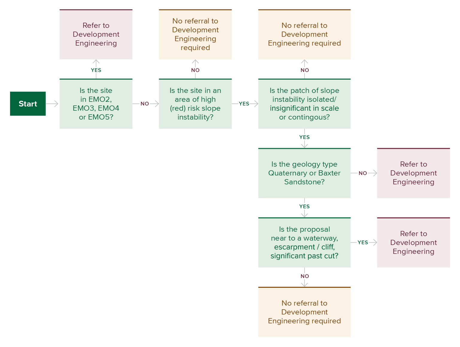
- At some point after receiving the 2012 Cardno report but prior to 2019, the Shire adopted a practice of imposing additional planning requirements on properties that were mapped by Cardno as falling within the high landslide susceptibility areas.52
- That practice was set out in Chapter 3 of this Report but should be repeated here. Those additional requirements were, and currently are, as follows:
- first, any planning permit applications for the development of land clearly in high landslide susceptibility (red) areas must be accompanied by a peer reviewed geotechnical report which complies with the AGS Guidelines 2007;53
- second, prior to the commencement of any works for the development, a Form B Structural/Civil/Geotechnical Engineering Declaration must be completed in compliance with the AGS Guidelines 2007 by both a registered structural or civil engineer (endorsed by the Victorian Business Licensing Authority) and a specialist geotechnical engineer or a specialist engineering geologist as defined by the AGS;54 and
- finally, upon completion of the works, but prior to occupation of the site, a Final Geotechnical Certificate must be completed by a specialist geotechnical engineer or a specialist engineering geologist as defined by the AGS.55
- Mr Simon accepted that this practice was not formally documented until March 2025 by the Shire’s Development Engineering team.56 Prior to this, the practice was said to be guided by a series of internal documents and on-the-job training.57
- The formally documented process essentially guides a statutory planner within the Shire as to when a planning permit application should be referred to the Development Engineering team. The formalised process applies to proposed developments that are to occur in or near areas subject to EMO2 to EMO5.58 A separate process is followed for developments in areas in or near EMO1, which was not explored in evidence.
- The Shire’s formalised process can be depicted as follows:
FIGURE 6.1: FLOWCHART DEPICTING THE SHIRE’S INFORMAL PROCESS FOR ASSESSING PLANNING PERMIT APPLICATIONS FOR LANDSLIDE RISK.
- If an application is referred to the Development Engineering team, the engineer assesses the proposal and provides recommendations as to site-specific conditions.60 Those conditions might include:
- before any works associated with the development start, a geotechnical investigation of the property is to be undertaken in accordance with the AGS Guidelines 2007 by a geotechnical consultant with expertise in slope stability, and a copy of the geotechnical report lodged with the Shire;
- before any works associated with the development start, a peer review of the slope stability investigation report must be undertaken by an independent geotechnical consultant with expertise in slope stability, and a copy of the peer review report lodged with the Shire;
- prior to occupation of the development, a Form F Geotechnical Declaration Final Structural / Civil Certificate, along with “as constructed” documents in accordance with the AGS Guidelines 2007 must be completed by a structural engineer registered as a Civil or Structural Endorsed Building Engineer with the Victorian Business Licensing Authority, and copies lodged with the Shire;
- all retaining walls must be designed by a qualified structural engineer in accordance with the recommendations of the geotechnical report; and
- all stormwater and subsoil drainage must be directed to a legal point of discharge in accordance with the recommendations of the geotechnical report and to the satisfaction of the Shire.61
- The Shire’s Statutory Planning team retains ultimate authority over the conditions to be imposed. However, according to Mr Simon, in the “vast majority of instances”, the Statutory Planning team follows a recommendation from the Development Engineering team to obtain a geotechnical report and have it peer reviewed before making any determination on the planning permit application.62
- Stepping back, the Shire’s process can be viewed as a proxy for having the EMO in place over areas of high landslide susceptibility. But is that proxy adequate?
Was the Shire’s response adequate?
- There are several reasons why the Shire’s process is not an adequate substitute for having an EMO in place:
- first, the Shire’s process for assessing landslide risk is triggered only when a planning permit application is submitted. The Shire’s process itself cannot compel a planning permit application in areas of high landslide susceptibility. Viewed in this way, the Shire’s process is reactive rather than proactive. By contrast, where an EMO applies, it requires a planning permit application to be made before any subdivision or other specified types of proposed developments are undertaken;
- second, adherence to the Shire’s process, unlike adherence to the requirements of EMO schedules, is not mandated by law. Mr Oz accepted that the additional requirements imposed by the Shire are not required by any legislation or regulation.63 Mr Simon accepted that EMO schedules, by contrast, are mandatory and have statutory force, and do not turn on the discretionary request of a statutory planner; 64
- third, and relatedly, without statutory force, the Shire’s process is vulnerable to being frustrated by applicants resisting requests for geotechnical reports or quantitative landslide risk assessments. Mr Simon accepted that such assessments lie at the higher end of the scale in terms of burden and cost, making resistance a more likely response.65 In the face of objections, and absent another source of authority to compel production,66 the Shire may be left without any landslide risk assessments at all; and
- fourth, the Shire’s process is not visible to the public at large. Until an application is lodged and assessed, there is no clear indication of which areas in the Mornington Peninsula are classified as having high landslide susceptibility, nor of what landslide risk assessments are required before proposed works can begin in those areas. Conversely, the scope and requirements of an EMO schedule are readily and openly available online – both to owners and to third parties with an interest in identifying landslide prone areas.
- Having regard to those limitations, the Shire could have updated or taken steps to update its EMO schedules after receiving the 2012 Cardno report. The informal process it adopted may have been adequate as a short-term solution, but it should not have been the solution.
- In oral evidence, Mr Simon suggested that the absence of an EMO schedule may be attenuated by the presence of another overlay which might trigger the need for a planning permit application for the proposed development. It was said that in considering that application, the planner might have regard to erosion risk and by extension landslide risk.67 That is an impoverished version of a control to prevent or mitigate landslides. It is no substitute for an EMO schedule. The Shire can do better.
At the time of the November 2022 landslides, more than a decade had passed since the 2012 Cardno report was issued. By any measure, it was unsatisfactory that the Shire had not even commenced updating its EMO schedules to incorporate areas identified as having high landslide susceptibility. Such areas included the McCrae escarpment on which the November 2022 landslides occurred.
Finding
The Shire could have, but did not, update the EMO schedules in the Mornington Peninsula Planning Scheme after receiving the 2012 Cardno report to incorporate areas identified as having high landslide susceptibility.
This was another missed opportunity to mitigate landslide risk.
The Shire could have, but did not, upgrade the stormwater drainage system on View Point Road prior to the November 2022 landslides
- It is uncontroversial that, prior to May 2023, the kerbs on View Point Road were in very poor condition due to stormwater drainage issues. Indeed, the Shire knew this for several years.
- In November 2017, DM Roads, a contractor of the Shire, surveyed the kerb and channel along the stretch of road from Prospect Hill Road to the end of View Point Road.68
- More than a year later, in 2019, the Shire used the survey data as the basis for a desktop condition assessment. The 2019 assessment identified the kerb and channel on View Point Road as needing renewal within the following five years.69
- David Smith, Director - Assets and Infrastructure of the Shire, gave evidence that the “condition of the kerb and channel [on View Point Road] was in very poor condition, which flagged that it needed to be renewed”.70
- In amplification, he explained:
During the 2019 assessment of the View Point Road kerb and channel, it was also identified that the existing drainage infrastructure in the area did not provide a continuous flow through a connected stormwater network. This was because the underground piped drainage systems from upstream terminated adjacent to 4 View Point Road, and stormwater was surcharged to the surface and directed to flow along the kerb and channel and into the next section of the underground drainage network adjacent to 22 View Point Road. It was observed that water was pooling in the kerb and channel along View Point Road, causing the growth of algae and accelerated deterioration of the kerb and channel.71
- The renewal of the kerb and channel was proposed for delivery in the 2020–2021 financial year. This did not occur. Mr Smith understood that the project was delayed as a result of adjusting scheduling to meet annual budgets and as a result of the effects of the COVID-19 pandemic. However, he acknowledged that he does not have a complete understanding of why the project was not completed in 2021 as he was not directly involved at the time.72
- In May 2023, approximately six months after the November 2022 landslides at 10–12 View Point Road, the renewal works on the kerb and channel on View Point Road commenced.73
- Counsel Assisting asked Mr Smith whether the lag between the identification of the need for renewal in 2019 and commencement of the works was typical. Mr Smith replied “Yes, I’d certainly say it’s not unusual”.74 He stated:
[W]e generally need to be able to adjust the program because we do try and align our kerb and channel renewal program with our resurfacing program, so when you resurface a road, because it’s very poor practice to go and resurface a road and then come back the next year and dig out all the edges and put [a] new kerb and channel down. So quite often we do have to sort of adjust and tweak the program as we go to really make sure we get the best value for [the] community and the outcome.75
- It is undeniable that the Shire must balance competing considerations when determining the timing of a renewal project. However, in circumstances where the kerb and channel were in “very poor condition” immediately adjacent to a steep escarpment – one that the Shire knew had high susceptibility to landslides – it is reasonable to query why the project was not approached with greater urgency.
- Mr Smith initially seemed not to understand the need for a quicker response. He said:
If the water’s not causing – like, it’s not actually – like, it’s only a small amount of water flowing down a kerb and channel it certainly is wearing down a kerb and channel quicker. It’s not great from an aesthetic and visual point of view.76
- Mr Smith, however, later accepted that the Shire’s system and maintenance program should account for the risk of water continually seeping through cracks in the kerb and channel, thereby saturating an area highly susceptible to landslides. He said: “I think that would make sense ... yes, if there’s evidence that something is a problem or a challenge or an issue we should absolutely be addressing it, yes”.77
The stormwater drainage issues on View Point Road cannot be swept aside as merely being “not great from an aesthetic and visual point of view”. Plainly, constant seepage of water through cracks in the kerb and channel into a steep escarpment carries risk – it can render the affected landscape more susceptible to landslides. That risk should have been addressed in a timely manner.
Finding
The Shire could have, but did not, upgrade the stormwater drainage system on View Point Road prior to the November 2022 landslides on 10–12 View Point Road.
This was another missed opportunity to mitigate landslide risk.
Inaction between the November 2022 landslides and the 5 January 2025 landslide
The Shire could have, but did not, update the EMO schedules in the Mornington Peninsula Planning Scheme following the November 2022 landslides
- Following the November 2022 landslides, the Shire did not consider extending EMO4 and EMO5 – whether on an interim or emergency basis – to the areas identified in the 2012 Cardno Report as having high landslide susceptibility. It likewise did not consider applying those EMO schedules to 10–12 View Point Road and neighbouring properties, nor did it seek the Minister for Planning’s authorisation to do so.78
- Mr Simon stated that the Shire did not consider taking such steps because:
the Shire considered its existing practice was adequate to guard against further landslide risk in that area. Further, the Shire was taking advice from experts and following that advice in relation to the steps to be taken in relation to the properties involved in the 15 November 2022 landslide.79
- Mr Simon also said that, since the November 2022 landslides were likely triggered by water, applying an EMO schedule to 10–12 View Point Road and neighbouring properties would have involved “applying the wrong tool to cure the wrong problem”.80 Relatedly, he said that, even if an EMO schedule had been in place over those areas, “then the chances are the landslide still would have happened”.81
- It may be accepted that the presence of an EMO may not have prevented the November 2022 landslides. However, it does not naturally follow that the Shire should not have applied an EMO schedule to 10–12 View Point Road and neighbouring properties following those landslides.
- The essential facts are simple:
- in 2012, Cardno characterised the escarpment at 10–12 View Point Road and neighboring properties as having high landslide susceptibility;
- about 10 years later, on 14 and 15 November 2022, landslides occurred at 10–12 View Point Road which caused damage to two properties at 2 Penny Lane and 3/613 Point Nepean Road;
- on 15 November 2022, the Shire issued Emergency Orders to prohibit occupation of those properties on the basis that there were “immediate safety concerns relating to landslip impact to building/s” and soil stabilisation measures were required;82 and
- on 28 November 2022, the Shire issued an Emergency Order on Mr and Mrs Borghesi to engage a geotechnical engineer to undertake an assessment of 10–12 View Point Road and provide recommendations to undertake make safe works to stabilise the land.83 Mr Flores, then a Senior Building Surveyor at the Shire, gave evidence that this direction was aimed at preventing a further landslide in the area of the November 2022 landslides.84
- Plainly, the Shire knew that the area in the vicinity of 10–12 View Point Road was susceptible to landslides. By its own admission, the EMO is the best planning tool the Shire has to prevent or mitigate landslides.85 It follows that the Shire should have, minimally, considered whether to apply the EMO to that area after the November 2022 landslides.
- The following year, in 2023, the Strategic Planning team at the Shire conducted a subsequent review of the Mornington Peninsula Planning Scheme.86 Amongst other items, the following was noted as a key area of work that remained outstanding from the 2018 Review: “Strengthening the mitigation of landslip risk through the review of susceptibility data and modelling and associated application of the Erosion Management Overlay”.87
The point was reiterated later in the review report:88
Issue Status Recommendation Landslip susceptibility and outdated Erosion Management Overlay mapping Strategic work is required to undertake a comprehensive review and update of the Shire’s inland landslip susceptibility data and modelling. Following this review, an update of the ordinance and mapping of the Environmental Management Overlays will likely be required. This work is yet to be funded, resourced and programmed. Complete the comprehensive review and update of the Shire’s landslip susceptibility data and modelling and update the ordinance and mapping of the Environmental Management Overlays. - Counsel Assisting asked Mr Simon whether the Strategic Planning team, as part of the 2023 Review, gave any consideration to the November 2022 landslides. He did not know. Mr Simon was also asked if the Strategic Planning team considered whether to seek an interim or emergency extension to the EMO to cover all the high landslide susceptibility area identified in the 2012 Cardno Report. He also did not know.89
- The 2023 Review identified that the implementation of Recommendations 210 and 211 of the 2018 Review had not yet started. It assigned Recommendation 211 a priority rating of “Medium”, notwithstanding that five years had elapsed since the recommendation was first made and that landslides had occurred just the year before.90
- Again, Mr Simon was unable to explain why Recommendation 211 was not implemented by the Shire following the 2023 Review. He was only able to point to the Shire’s limited resources and other competing priorities.91
- It may be accepted that the Shire operates within resource and budget constraints. It may also be accepted that imposing the EMO is a multi-phased process that takes considerable time and State Government approval. However, doing nothing to review and update landslide susceptibility data – despite being on notice for over a decade of the risk, and having direct knowledge of a destructive landslide impacting multiple residents – was unacceptable. This inaction fell well short of the Shire’s own current stated commitment “to the highest standards of performance, behaviour and service”.92
The Shire accepts, on reflection, that it could have fully implemented Recommendation 211 more expeditiously. The Board of Inquiry was informed by the Shire that it is presently actively procuring updated modelling and ordinance mapping in accordance with that recommendation.93 However, the Board of Inquiry was also recently informed by letter dated 2 September 2025 that the Shire has not yet engaged a geotechnical engineer to update the landslide susceptibility data and that it expects that the engineer may take almost two years to complete the assessment.94 No explanation was provided by the Shire for not yet having engaged a geotechnical engineer.
Finding
The Shire could have, but did not, make an application to the Minister for Planning to update the EMO schedules in the Mornington Peninsula Planning Scheme following the November 2022 landslides to incorporate areas identified as having high landslide susceptibility.
This was another missed opportunity to mitigate landslide risk.
Finding
The Shire is not utilising its “primary and most effective control to prevent or mitigate landslide and erosion” in areas of high landslide susceptibility being the EMO.
Recommendation 6: EMO The Board of Inquiry recommends the Shire progress the work that is currently underway to amend the existing EMO schedules, or add a new schedule, to the Mornington Peninsula Planning Scheme, which has the effect of applying an EMO to at least those areas of the Shire that are highly susceptible to landslides. The Shire should take advice from a geotechnical engineer as to the appropriate scope of the schedule(s).
The Shire could have, but did not, assess landslide risk in McCrae with a view to formulating a plan to mitigate the risk of further landslides following the November 2022 landslides
- It is natural to query what the Shire did following the November 2022 landslides to mitigate landslide risk in McCrae. Cardno’s assessment of the escarpment having high susceptibility to landslide had proven real. Properties had been damaged and multiple residents had been displaced.
- In view of this, did the Shire, for example, undertake or commission risk assessments to determine the likelihood and severity of further landslides in McCrae?
- The short answer to that question is “no”. As Mr Simon explained, while landslide risk assessments were obtained in respect of properties in the immediate vicinity of 10–12 View Point Road, the Shire did not obtain any wider risk assessments to determine the likelihood and severity of landslides in McCrae.95
- The Shire submitted to the Board of Inquiry that it was under no obligation to do so. It said that its actions after the November 2022 landslides were appropriate and reasonable in the context of the advice received from geotechnical experts relating to the cause of the landslides and magnitude of any further landslide and cohered with the Shire’s statutory responsibilities.96
- It bears repeating the actions the Shire, through the office of the Municipal Building Surveyor (MBS), took following the November 2022 landslides, namely it:
- sought geotechnical advice on the causes of those landslides;97
- issued Emergency Orders for the evacuation of affected properties;98
- liaised with the owners of 10–12 View Point Road, the Borghesis, to develop a plan for stabilisation works to be undertaken by them;99 and
- issued Emergency Orders and Building Orders directing the carrying out of stabilisation works at 10–12 View Point Road.100
- It can readily be observed that the first steps were not principally directed to understanding the risk of or preventing the occurrence of further landslides in McCrae. As Mr Flores properly accepted, the second step could not itself prevent the occurrence of a further landslide; it was a step he took in an attempt to protect the owners and occupiers of those properties.101
- The last two steps were directed to understanding the risk of or preventing the occurrence of a further landslide on the Borghesis’ property but, as it has recently been determined, the Shire did not have the jurisdiction to issue those orders.102
- The Shire further submitted that any responsibility to obtain risk assessments to determine the likelihood and severity of further landslides in McCrae must be worked out through the State Emergency Management Plan (SEMP). It emphasised that the VicSES – not the Shire – is the “control agency” for a landslide event under the SEMP, and it is the VicSES that maintains the State Landslide Hazard Plan.103
- True it is that the VicSES is the control agency for landslides in the “response” phase under the SEMP – that is, the agency “primarily responsible for managing the response to an emergency” and for “establishing the management arrangements for an integrated response to the emergency”.104 However, that says nothing about what the Shire can or cannot do to contribute to the mitigation of landslides.
- There was, and is, nothing in the SEMP that precluded the Shire from taking steps to gain a better understanding of landslide risk in McCrae with a view to mitigating such risk. Indeed, the SEMP states “[e]ven when not required by law, departments, agencies, businesses and the community are key actors to take actions to mitigate and reduce risk to emergency shocks and stresses”.105
- Following the November 2022 landslides, the Shire could have, for example, worked with the Mornington Peninsula Municipal Emergency Management Planning Committee to assess landslide risk in McCrae. As explained in greater detail in Chapter 8 of the Report, that committee is chaired by a representative of the Shire and comprises representatives from various agencies such as Victoria Police, the VicSES and the Department of Transport and Planning.106 The committee serves several functions, including to identify and evaluate risks that could impact the municipality and to implement measures to reduce the likelihood of them materialising.107
- It is noted that the ‘role statement’ for councils on the Emergency Management Victoria website expressly states that a council’s mitigation activities include working with the Municipal and/or Regional Emergency Management Planning Committee to: identify and assess hazards/risks; implement/coordinate specific risk treatments for identified risks; and provide community awareness and information.108
- Had the Shire engaged with the Mornington Peninsula Municipal Emergency Management Planning Committee following the November 2022 landslides, this may have led to the development of a mitigation plan that entailed:
- a review of the adequacy of the Shire’s informal practice of imposing additional planning requirements on properties falling within the high landslide susceptibility areas mapped by Cardno;
- a review of the Shire’s policies and procedures for maintaining stormwater infrastructure in those susceptible areas to account for landslide risk;
- implementing policies and procedures for responding to reports of water leaks or excess water in those susceptible areas; and
- informing relevant Shire staff, SEW and residents about the susceptible areas so they could take appropriate mitigation steps.
- The Shire appeared to defend the absence of such a mitigation plan in submissions to the Board of Inquiry on the basis that, even if one had been in place, it would not have prevented the 5 January 2025 landslide or the McCrae Landslide from occurring.109 Even if that is so, it cannot be said that such a plan would have been bereft of utility.
- In fact, today, the Shire is currently working towards improving its systems and processes, including by:
- planning a strategic assessment of landslide risk patterns across the full escarpment area, involving a systematic evaluation of geological conditions, historical landslide frequency, building characteristics, and the adequacy of Shire infrastructure in the vicinity of the escarpment;110
- amending the existing EMO schedules to apply to those areas of the Shire falling within the high landslide susceptibility areas mapped by Cardno;111
- reviewing its existing stormwater infrastructure to identify potential seepage points, as well as updating its Asset Management Strategy and Stormwater Asset Management Plan, and incorporating more specific information relating to landslide susceptibility and risk into those documents and the planning of the maintenance and renewal of stormwater assets in general;112
- planning improved data collection and notification processes so that the Shire can identify more readily when multiple customer requests/complaints are made to the Shire (or identified by its contractors) in the same or similar areas;113 and
- engaging in conversations with SEW about improved processes for the notification of water main bursts.114
- Further, the Shire acknowledges that the community and other statutory agencies/authorities could benefit from the sharing of information held by the Shire about landslide susceptibility across the municipality so that they can take steps to mitigate against the risk of landslide.115 The Board of Inquiry agrees.
- The symmetry between what the Board of Inquiry has identified as the mitigation steps that could have been taken following the November 2022 landslides and what the Shire is currently doing following the 5 January 2025 landslide and the McCrae Landslide is striking.
- There is nothing before the Board of Inquiry to justify why these initiatives could not have been prioritised and implemented before a landslide in the order of 300 cubic metres destroyed the Morans’ house.
As formally recommended later in this Chapter, the Shire should promptly progress these initiatives.
Finding
The Shire could have, but did not, assess landslide risk in McCrae with a view to formulating a plan to mitigate the risk of further landslides following the November 2022 landslides.
This was another missed opportunity to identify and mitigate landslide risk.
The Shire could have, but did not, prepare a comprehensive plan for responding to another landslide event following the November 2022 landslides
- Another question that arises is whether the Shire prepared a comprehensive plan for responding to another landslide event following the November 2022 landslides.116
- According to the Shire, it did have a plan. Namely, a municipal-level plan for various kinds of emergencies, being the Municipal Emergency Management Plan (MEMP). The MEMP was prepared and reviewed by the Municipal Emergency Management Planning Committee.117
- In simple terms, the MEMP contains provisions that provide for the mitigation of, response to, and recovery from emergencies in the Mornington Peninsula municipality.118
- The problem with the MEMP, however, is that it did not, and does not, identify landslide as a standalone risk. Instead, the MEMP assumes that a landslide is a secondary event that occurs following a significant weather event, such as intense rainfall or an earthquake.119 But as the McCrae Landslide has demonstrated, it is not invariably the case that a landslide is a secondary event.
- The MEMP by its own terms exposes that it is not a comprehensive plan for responding to another landslide event.
- The Shire implicitly recognised as much as, in late 2021, it developed a flow chart setting out the process it would follow upon being notified of a landslide. This flow chart was subsequently updated in 2023.120 In summary, the response process reflected in the flow chart involves notification procedures, safety assessments, stakeholder engagement, geotechnical investigation, and project management steps for remediation.121
- While the flow chart appears to be elaborate on its face, with multiple layers and processes, there are notable omissions. For example, the response process makes no provision for how the Shire should engage with water entities such as SEW where a landslide appears to be triggered by water. It also lacks protocols for the timely sharing of information in circumstances where the cause of a landslide is unclear and warrants immediate investigation. Most critically, the process makes no provision for urgent stabilisation or other mitigation works to be undertaken where there is a risk of a further landslide.
- This gap leaves the Shire without a structured means of responding to a landslide event decisively, thereby increasing the risk that a relatively minor landslide will escalate into a more destructive landslide.
- Had a dynamic and coordinated response process been in place, incorporating the features identified above, the Shire’s approach in the aftermath of the 5 January 2025 landslide could have been different – it could have been better. Adherence to such a process would likely have encouraged more effective co-ordination between the Shire and SEW. While it may not have prevented the McCrae Landslide, it could certainly have reduced inefficiencies, avoided unnecessary diversion of resources, and minimised information asymmetries.
- It bears repeating that the Board of Inquiry is acutely aware that the Shire is not designated as the relevant “control agency” for landslides in the “response” phase under the SEMP – that responsibility rests with the VicSES. Nothing in the foregoing analysis is intended to superimpose obligations on the Shire contrary to the SEMP. However, this does not diminish the need for the Shire to have its own response process. The absence of a formal obligation in the SEMP does not absolve the Shire from ensuring that it can respond in a timely, coordinated and informed manner when a landslide occurs. In fact, over the nine days that followed the 5 January 2025 landslide, the Shire’s MBS was looking for the source of the water and taking other steps to try to mitigate the risk of a further landslide. However, in the absence of the Shire having a proper process or plan, the response was ad hoc and limited.
Having regard to the history of landslides and ongoing landslide susceptibility in its municipality, the Shire needs a comprehensive and thoughtfully designed plan for responding to landslide events.
Finding
The Shire could have, but did not, prepare a comprehensive plan for responding to another landslide event following the November 2022 landslides.
This was another missed opportunity to mitigate landslide risk.
Recommendation 7: Process for responding to landslide incidents The Board of Inquiry recommends the Shire review and improve its processes for responding to landslide incidents with a view to including, amongst other things:
a. protocols for timely information sharing with relevant entities, agencies and individuals; and
b. mechanisms for urgent steps to be taken to mitigate the risk of a subsequent landslide, such as contacting the VicSES when there is a threat of a subsequent landslide, and using equipment on Shire or private land (with permission) to try to divert hazardous water flow.
The Shire could have, but did not, take effective measures to address the water that was surfacing on Charlesworth Street, Coburn Avenue and Waller Place
- Water upwelled on the streets uphill of Penny Lane from at least November 2024. As outlined in Chapter 3, the water bubbled up through the roads, damaged bitumen, created potholes and flowed down the streets.
- Residents of McCrae raised their concerns with the Shire. The complaints were numerous.
- The Shire attended in response to those complaints. It did so relatively quickly. But the actions taken by the Shire to address the water issues were neither effective nor optimal.
- The Shire disagrees. It maintains its response was “more than adequate, and very responsive”. It submits that it should not be blamed for the “colossal failure of SEW” and that its responsibilities begin and end at stormwater infrastructure (and even there, those responsibilities are only to a limited degree, with stormwater assets being managed by several different agencies other than the Shire, including VicRoads, Melbourne Water and private persons).122
- Obviously, no blame can be assigned to the Shire for the burst water main. However, it remains the case that the Shire’s responses to the water issues throughout November and December 2024 were not “more than adequate”.
- By way of illustration, on 20 December 2024, the Shire’s Roads Corridor and Drainage team attended Charlesworth Street and placed bollards and tape up around the area where water was “streaming out of the road”.123 Fulton Hogan also noted that a “make safe for [the] pothole with water ingress [had been] installed”.124 There is no evidence before the Board of Inquiry that suggests such make safe works involved more than erecting bollards and tape.
- On any view, those actions were not “more than adequate” – indeed far from it.
- A survey of the chronology in Chapter 3 shows that the water issues were addressed through largely superficial measures. Hazard signs were erected, bollards and tape were put up, and, on occasion, potholes were (temporarily) repaired. Nothing was done to address the subsurface flow of water, notwithstanding that water had been flowing out of the ground for weeks and it was evident to one local resident that a “massive washout” was imminent.125
- It was not until on or about 16 January 2025, after the McCrae Landslide, that the Shire instructed Fulton Hogan to undertake works at the intersection of Waller Place and Charlesworth Street. Mr Smith gave evidence that the works were “required due to saturation causing potholes on Charlesworth Street that were unable to be repaired from the surface ... it is my belief that the [works] involved excavating the road base and laying Agi pipes to collect water and drain the pavement into the adjacent drainage pit”.126
- Mr Cooper was present when those works were undertaken. The first thing he said to one of the Shire representatives was “[i]t took a house falling down the hill for you to address these water issues”.127 He told the Board of Inquiry that his comment was prompted by the following sentiment:
[I]t just felt like we had been walking around in circles for weeks and weeks, handballing whose fault and problem this was, and no one wanted to dig a hole in the ground and look or do anything until something bad had happened.
[The Shire and SEW] would talk amongst themselves about who’s owning the water now, and if it ... entered the stormwater pipe it was the council’s, if it was a spring, it’s like no one seemed to know.128
- Mr Cooper thought the unwillingness to take responsibility for the water issues was “the biggest stumbling block to the whole affair”.129
- The Board of Inquiry agrees.
- It appears that the Shire did not take any serious measures throughout November and December 2024 to address the water issues – such as trying to divert the water into the stormwater system – for a multitude of reasons, chief among them that it did not consider the surfacing water to be its responsibility. Added to that, the Shire did not fully appreciate how the water issues had a bearing on landslide risk.
- Had the Shire fully appreciated that risk, the approach to addressing the water issues would likely have been different. It is reasonable to expect that the Shire would have promptly shared with SEW that the water was surfacing in an area adjacent to a zone of high landslide susceptibility. Similarly, it is reasonable to expect that the Shire would have demanded that SEW treat the issues with urgency given the heightened risk of excess water in such an area. It is also reasonable to expect that the Shire itself would have treated the matter more seriously by, for example, diverting the subsurface water into the stormwater system much earlier.
It is difficult to imagine that the Shire, properly informed about landslide risk, would have been satisfied with the installation of bollards and tape as the predominant solution to the water issues. Such measures were inadequate at the time and they are inadequate moving forward. The Shire can do better and it should do better.
Finding
The Shire could have, but did not, take effective measures to address the water that was surfacing on Charlesworth Street, Coburn Avenue and Waller Place. It did not, for example, seek to divert the subsurface water flow into the stormwater system prior to the 5 January 2025 landslide.
This was another missed opportunity to mitigate landslide risk.
Recommendation 8: Process for responding to water incidents The Board of Inquiry recommends the Shire review and improve its processes for responding to incidents of water upwelling in and around areas highly susceptible to landslides.
Inaction between 5 and 14 January 2025
- The 5 January 2025 landslide occurred on a Sunday evening. The McCrae Landslide occurred nine days later, on a Wednesday morning. Those nine days were pivotal.
- During that period, unexplained water flowed out of the unstable headscarp of the site of the 5 January 2025 landslide. The water did not stop. It did not consistently abate. It signalled a further landslide.
- What was done by the Shire during that critical period?
- It is acknowledged that the Shire took multiple steps to respond to the 5 January 2025 landslide. Indeed, Shire representatives were on the scene approximately four hours after the landslide occurred to inspect the site.130 In the days that followed, the steps they took included:
- promptly seeking geotechnical advice from Mr Pope of PSM with a view to, amongst other things, controlling the water flowing under the Morans’ house;131
- inspecting the escarpment at 10–12 View Point Road daily during the working week;132
- examining the building works that had been carried out at 10–12 View Point Road, as well as considering building permits and historical subdivision documents issued for the property;133
- reviewing the Shire’s customer complaint system to identify any reports concerning water in the vicinity of Prospect Hill Road and View Point Road;134
- investigating the source of the water infiltrating the headscarp, including:
- conducting dye testing in the Shire’s stormwater assets from Prospect Hill Road to View Point Road to determine whether the water running out of the escarpment had originated from those assets;
- inspecting water meters of properties near 10–12 View Point Road;
- inspecting hydrant groundballs for leaks;
- undertaking water sampling and testing of surface water from the landslide site and uphill streets;135
- preparing an ‘Actions Items’ document to provide to the Morans, Borghesis and Willigenburgs, setting out steps for the former two families to, amongst other things, divert surface water away from the headscarp and 3 Penny Lane;136
- overseeing the installation of the water diversion plan at the Morans’ house, namely the installation of a pipe under the house to divert the water under the Morans’ deck to reduce the hydrostatic load;137 and
- liaising with the Morans’ insurer about whether ballasted shipping containers could be brought on-site and installed in the northern most section of the lawn, to act as a temporary debris barrier in the event of a further landslide.138
- In view of the above, the Shire was actively involved – specifically through the MBS, Mr Glover, and the Office of the MBS – in responding to the 5 January 2025 landslide. It is accepted that the response was, to use Mr Glover’s words, “both labour and time intensive”.139 However, due to an absence of executive leadership and emergency preparation, the Shire did not take the more critical steps.
- There are three key actions the Shire did not take in the period between 5 and 14 January 2025:
- it did not appropriately resource its response;
- it did not escalate or change its response to the developing emergency as water continued to infiltrate the unstable headscarp; and
- it did not take steps, together with SEW, to try to intercept the subsurface water flow upslope of the landslide site and to direct it away from the site.
- Each of those inactions will be considered in detail below.
- While it is not possible to know whether the taking of such steps would have prevented or reduced the magnitude of the McCrae Landslide, it is evident that such steps could have been taken and that they might have changed the ultimate outcome.
The Shire did not appropriately resource its response to the 5 January 2025 landslide
- For the avoidance of doubt, the term “response” in this section is again used in its ordinary sense. It is not intended to bear the particular meaning it has under the SEMP.
- The chronology of events following the 5 January 2025 landslide, outlined in Chapter 3, exposes two striking features of the Shire’s approach to resourcing its response to that landslide:
- first, the response was led principally by the MBS and the Office of the MBS – namely, Mr Glover, Mr Flores and Mr Jones – in consultation with Mr Pope; and
- second, and relatedly, the Shire’s executive leadership were not actively involved in managing the risks of a further landslide.
- The Shire’s approach was unduly limited. The response demanded more than reliance on the MBS, whose functions are circumscribed by the Building Act and the Building Regulations 2018 (Vic) (Building Regulations). The response required enhanced monitoring and active oversight by the Shire’s executive leaders, including the Acting CEO. The Mayor should have also requested regular detailed updates.
- To appreciate why the response required more than just the involvement of the Office of the MBS, it is necessary to address the following questions:
- What are the functions of the MBS and the Office of the MBS?
- Why did the Shire allow the Office of the MBS to effectively lead the response to the 5 January 2025 landslide?
- What steps did the Shire’s executive leadership take to respond to the risk of a further landslide following the 5 January 2025 landslide?
- The answers to those questions are set out in turn.
What are the functions of the MBS and the Office of the MBS?
- Shortly stated, the functions of the MBS and the Office of the MBS revolve around building compliance, including issuing building permits, inspecting building work, issuing occupancy permits, and enforcing safety and building standards.
- The MBS is a statutory position established under the Building Act and Building Regulations, which, together, regulate building works and standards in Victoria. Every local government must appoint an MBS to administer Parts 3, 4, 5, 7 and 8 of the Building Act and Building Regulations within its municipal district.
- Relevantly, between 5 and 14 January 2025, Mr Glover was the Shire’s MBS.140 His functions as MBS included:
- responding to building-related emergencies, dangerous buildings and dangerous land, including issuing emergency orders;
- investigating suspected non-compliance with the Building Act and Building Regulations, including exercising powers of entry, seizure and testing, and to request documents; and
- enforcing compliance with the Building Act and Building Regulations, including through issuing building notices and orders, and infringement notices.141
- The Office of the MBS is comprised of employees at the Shire who assist the MBS in carrying out their functions under the Building Act or Building Regulations.142 In broad terms, it is responsible for ensuring buildings and places of entertainment in the Shire are safe for people to use. In doing so, the Office of the MBS is particularly focused on compliance of building works, the safe conduct of public events, and responding to emergency events involving buildings, such as fires, floods or landslides.143
- The powers of the MBS and Office of the MBS to respond to landslides are, therefore, limited – and even more limited when it comes to preventing or mitigating landslides.
- Mr Glover explained the limitations as follows:
[T]he Office of the MBS and the MBS did not have powers to prevent or mitigate landslides unless a building or structure was impacted, and even then, the powers were limited to directing work to be carried out in respect of the damaged building or structure.144
- Mr Glover went on to say the MBS’s role is “only related to building/structural damage under the Building Act”. He also said that the Building Appeals Board decision in relation to 10–12 View Point Road dated 30 April 2025 “demonstrates the significant limits” of the MBS’s powers.145 In that decision, the Building Appeals Board decided, amongst other things, that the MBS can issue Building Notices and Emergency Orders to an owner of land in respect of land on which building work is being or is proposed to be carried out, but not in respect of land simpliciter.146
- Accepting the correctness of Mr Glover’s evidence, and the decision of the Building Appeals Board, it is a short step then to conclude that the Office of the MBS was ill-suited to serve as the Shire’s leading response body to the 5 January 2025 landslide.
- So, how was it that the Shire’s MBS (Mr Glover), Senior Building Surveyor (Mr Flores) and a Building Inspector (Mr Jones) came to be the Shire’s key actors in the response effort?
Why did the Shire allow the Office of the MBS to effectively lead the response to the 5 January 2025 landslide?
- The first matter to note is that, on 5 January 2025, the VicSES, as the control agency under the SEMP, was primarily responsible for managing the response to the landslide.147
- Mr Simon gave evidence that the Shire’s Emergency Management team was not activated in response to the landslide. He pointed to two factors. First, the VicSES did not, on 5 January 2025 or subsequently, ask the Shire to supply physical equipment and assets needed to undertake emergency management activities. Second, there were no displaced residents requiring temporary accommodation at that time.148
- Mr Brick, Team Leader of the Shire’s Emergency Management team, corroborated Mr Simon’s evidence. He said that, for the reasons given by Mr Simon, the Shire’s recovery responsibility was limited to the tasks of the MBS.149
- On 5 January 2025, the Shire acted on the instruction of the VicSES and deployed the MBS – namely Mr Glover and Mr Jones – to the landslide site.150 Mr Glover said that the Office of the MBS was there that night to “provide a response and professional support to VicSES under the Building Act … for building safety”.151
- The second matter to note is that, on 6 January 2025, the VicSES determined that it was no longer needed to lead and manage the response to the landslide and it deactivated its services as Incident Controller.152
- Mr Glover recounted that on 6 January 2025, he met with the VicSES officers on-site who told him that there was nothing else the VicSES needed to do and that the site now fell under the Building Act.153
- Thereafter, the Shire did not decide that Mr Glover was the appropriate person to have responsibility for the site. Rather, Mr Glover’s functions as the Shire’s MBS were activated by the incident because the Morans’ house was impacted by the landslide and an assessment and determination regarding the occupancy of that damaged residential building was required of him.154
- No other person within the Shire, other than the MBS or a delegate of the MBS, had (or has) the power under the Building Act (or other statute) to conduct that assessment. However, as the chronology outlined in Chapter 3 makes clear, Mr Glover and his team assumed responsibilities well beyond conducting that assessment in the days following the landslide. In effect, those individuals became the drivers of the response, taking on tasks that included investigating the source of the unexplained water.
- Ultimately, the MBS and the Office of the MBS, assumed the lead in responding to the 5 January 2025 landslide not by deliberate choice, but through circumstance and the inaction of the Shire’s other divisions.
What steps did the Shire’s executive leadership take to respond to the risks following the 5 January 2025 landslide?
- Having identified the MBS and the Office of the MBS as the Shire’s key personnel involved in responding to the 5 January 2025 landslide, the next question is: to what extent was the Shire’s executive leadership involved in the response?
- The answer is short: very little.
- The extent to which the Shire’s executive leadership was involved in the response can be summarised as follows. Some of it was outlined in Chapter 3 but should be repeated here.
- On 6 January 2025, Mr Glover first reported the landslide to two senior individuals to whom he reported within the Shire’s organisational structure: Mr MacDonald, Manager – Development Services, and, Ms Littlejohn, Director - Planning and Environment.155
- On 7 January 2025, he told Ms Littlejohn and Mr MacDonald, amongst other things, that the VicSES had handed over the site to the MBS, water was flowing from the headscarp at a rate of around 200 millilitres per second (equivalent to 12 litres per minute) and Mr Pope was going to provide a preliminary report regarding the possibility of the Morans’ house collapsing and affecting property along Point Nepean Road. He also told them that the Office of the MBS was conducting ongoing investigations in connection with the unexplained water at the landslide site, including undertaking water tracing.156
- Ms Littlejohn sent a brief update email to the Mayor and the Shire’s Acting CEO, Mr Oz:
This is a FYI regarding a landslide for 3 Penny Lane McCrae.
The team, led by our MBS, have been dealing with this situation after the SES handed the site over yesterday.
The affected premises has sustained structural damage to the rear and appropriate action is currently being taken to manage the site.
I will keep you in the loop as things evolve.157
- On the same day, after being forwarded Mr Pope’s preliminary risk assessment by Mr Glover, Ms Littlejohn confirmed that she had put the landslide on the Mayor’s “radar” and would follow up with him “in case it gets out there and political”.158
- On 8 January 2025, Mr Glover provided another update to Ms Littlejohn and Mr MacDonald. He assessed Mr Pope’s recommended action items for the Borghesis and Morans as “reasonable to protect the life and safety of the surrounding property”. He reported that the trace dye exercise indicated that the water at the landslide site was not coming from the Shire’s drainage assets. He left it to Ms Littlejohn to brief the Mayor and the Shire’s leadership about the situation and proposed actions.159
- Shortly after, both the Mayor and Acting CEO briefly responded to the email Ms Littlejohn had sent the previous day. The Mayor stated:
I know there was a legal matter on a similar issue (landslip damage to property in McCrae).
Do we know of any potential legal implications/liability here?160
- Mr Oz copied in Mr Rotter, Manager - Infrastructure Projects at the Shire, to ask whether he had “any ideas on implications for us?”. Mr Rotter replied, stating that his team, Infrastructure Projects, had not been involved in this “new landslip”. He understood that the situation was being managed by the Office of the MBS. He deferred to Ms Littlejohn to provide further information.161
- On 9 January 2025, Mr Rotter drove past the landslide site. He sent an email to Mr Oz, Ms Littlejohn, Mr MacDonald and others stating that there was a significant volume of water flowing, indicating that the “land has a significant high-risk of slipping again”.162
- Notwithstanding this alarming information, Mr Oz simply asked if Mr Rotter and Ms Littlejohn could take care of the situation or suggest an “alternative approach”. Ms Littlejohn replied that Mr Glover’s team was monitoring the situation “carefully so we can take advice from him as the need arises”.163
- Later in the day, Mr Glover sent another update email to Ms Littlejohn and Mr MacDonald advising that work was commencing on-site to reduce the hydrostatic loads on the Morans’ property, which would involve “water being pumped via the surface along Penny Lane until the water source is known”. He explained that the investigations to date, including dye trace testing and water sampling, provided no evidence of the cause of the water discharging at 10–12 View Point Road.164
- On 13 January 2025, the day before the McCrae Landslide, Mr Glover copied Ms Littlejohn and Mr MacDonald into an email update, noting that water was still discharging at around 15 litres per minute from the escarpment.165
- Beyond this brief email correspondence, it does not appear that the Shire’s executive leadership took any substantive role in responding to the landslide. There is no evidence of them doing anything to manage the risk of a further landslide. They deferred to Mr Glover and his team.
- The Shire’s leaders, including the Mayor and Acting CEO, appear to have trusted that enough was being done through the MBS and Office of the MBS to manage the situation. No other resources from the Shire were deployed despite Mr Rotter warning that there was a “significant high-risk” of a further landslide.166 The Shire’s executive leadership adopted a passive approach, leaving the Shire’s response to the landslide inadequately resourced. That was unsatisfactory. The situation needed to be carefully and actively managed by a team of people with different experience and skills, including experience in emergency management. The impacted residents needed the Shire’s executive leadership to be engaged and committed “to the highest standards of performance, behaviour and service”.167
Five days after Mr Rotter’s prescient warning, the McCrae Landslide occurred.
Finding
Following the 5 January 2025 landslide, the Shire did not appropriately resource its response to the landslide. The response was principally led by the MBS and Office of the MBS, in consultation with Dane Pope of PSM. Given the seriousness of the situation, the Shire’s executive leadership should have exercised oversight and provided guidance. The Mayor should also, at the very least, have required regular, detailed updates.
The Shire did not appropriately escalate its response to the developing emergency as water continued to infiltrate the unstable headscarp
- It is difficult to reconcile the Shire’s response to the 5 January 2025 landslide with the evidence that water was continuously infiltrating the headscarp of the landslide and destabilising it.
- The unexplained water started flowing out of the escarpment as soon as the landslide occurred. Mrs Moran and her daughter watched it pool inside their house,168 and for nine days it did not stop:
- Day 1 (the day after the landslide): water continued flowing with no sign of easing.169
- Day 2: water was observed flowing from the headscarp at about 12 litres per minute,170 causing concern to Mr Flores.171
- Day 3: the flow increased to about 15 litres per minute, as observed by Mr Borghesi, who reported this to Mr Flores.172
- Day 4: water was seen running from the Morans’ property and down Penny Lane.173
- Day 5: the water had carved a defined pathway down the escarpment.174
- Day 6: despite the installation of a diversion system under the Morans’ deck the previous day, the water breached their front retaining wall.175
- Day 7: water was flowing constantly along the west side of the Morans’ property, down Penny Lane and towards the spoon drain on Point Nepean Road.176
- Day 8: the volume of water increased further, likely exacerbated by weekend rainfall.177
- Day 9: the flow persisted, and the McCrae Landslide occurred.
- It should have been very clear to the Shire as the days marched on, and water continued to flow out of the escarpment, that another emergency was unfolding. Indeed, several people identified the threat of another landslide.
- On 7 January 2025, it was clear to the assessor who was appointed by RACV to inspect the Morans’ property. He reported that the house was “extremely unsafe and unstable” and that “there is a chance that further movement could occur, and more damage to the property would be immediate”.178
- On 9 January 2025, it was certainly clear to Mr Rotter who thought there was a significant risk of a further landslide after seeing the volume of water flowing from the Morans’ property.
- It was equally clear to the Borghesis, who had the clearest vantage point of the headscarp, and who were “absolutely, categorically” concerned that there might be a further landslide.179
- On 9 January 2025, Mr Borghesi told Mr Glover that the flow of water had increased, a small landslip had occurred at the head of the scarp and cracks were appearing south of a gum tree.180 He also sent Mr Flores a text stating, “Claude, a small amount of soil (0.5m3) collapse from near the gum tree, the tree is at risk”.181
- Over the weekend of 11 and 12 January 2025, Mr Borghesi contacted the Shire again to convey his concerns about the further degradation of the headscarp.182
- On 13 January 2025, the day before the McCrae Landslide, Mr Glover exchanged text messages, including photos, with Mr Pope about the condition of the headscarp. He said that things were “[n]ot good”. Mr Pope acknowledged that the wedge in front was “slowly failing”.183
- Faced with the threat of a further landslide, the Shire did not seek to re-engage with the VicSES to activate an emergency response.
- Mr Brick stated that, to the extent the SEMP applied, the MBS undertook his responsibilities in accordance with Table 17 of the SEMP. Specifically, Mr Glover conducted a survey and made a determination regarding the occupancy of damaged residential buildings (when safe to do so).184 That may be accepted.
- There was, however, nothing in the SEMP to prevent the Shire from contacting the VicSES to seek an emergency response to the imminent occurrence of a landslide, which threatened to endanger the safety of residents and to destroy or damage property. That is the very definition of an emergency.185 But the Shire did not act.
- The Shire should have escalated – or at the very least considered escalating – the developing threat of a further landslide to the VicSES before 14 January 2025, but it did not. Again, while it is not possible to know whether such action would have prevented the McCrae Landslide, there is at least a possibility it would have done so or would have lessened the consequences of the McCrae Landslide. The VicSES may have, for example, sought to urgently remove soil from the headscarp using a long arm excavator, sought to intercept the continued water flow to the headscarp and/or placed barriers at the bottom of the escarpment to stop debris flow from impacting properties.186
The reason the Shire did not consider seeking assistance from the VicSES seems to stem from the inadequate resourcing of the Shire’s response to the landslide, with no one knowledgeable and experienced in emergency management involved. Mr Glover was following the advice received from geotechnical engineer Mr Pope on 7 January 2025 that “some of the Property owners should take steps to mitigate the risk of further landslide activity while cause/repairs are investigated further, and insurers respond”.187 He gave the owners action items provided by Mr Pope, but, in the absence of any appropriate leadership from the Shire, he did not consider whether more could and should have be done urgently.
Finding
Following the 5 January 2025 landslide, the Shire did not appropriately escalate its response to the developing emergency as water continued to infiltrate the unstable headscarp. It did not, for example, re-engage with the VicSES to seek an emergency response to the threat of a further landslide.
The Shire could have, but did not, take steps, together with SEW, to try to intercept the subsurface water flow upslope of the site and to direct it away from the landslide site
- During those critical eight full days between the 5 January 2025 landslide and the McCrae Landslide, no one uncovered the source of the water infiltrating the headscarp.
- Multiple theories were posited. Mr Glover initially thought the water was coming from a natural spring,188 and later thought it may have been caused by a potential failure in the Shire’s drainage system.189 The Morans’ insurer thought the water was coming out of a pipe.190 SEW thought the water may have been leaking from its assets in the vicinity of the landslide and accordingly surveyed the area.191
- In the face of this uncertainty, Mr Glover and his team were, therefore, keenly focused on locating the source of the water. They inspected various infrastructure, namely surrounding water meters, hydrant groundballs, road kerb collectors and stormwater pits. They conducted dye trace testing in stormwater lines from Prospect Hill Road and View Point Road. They tested water that had surfaced at the landslide site and neighbouring streets. Despite their best efforts, their investigations did not lead them to the source of the water.192
- During those eight days between the 5 January 2025 landslide and the day of the McCrae Landslide, both the Shire and SEW were preoccupied with locating the water’s source. But was that the best use of their time and resources?
- Mr Borghesi resoundingly answered “no”. In Mr and Mrs Borghesi’s view, the source of the water was “completely irrelevant”. What was relevant was that water was flowing subsurface and coming out of the headscarp. It needed to be intercepted before it triggered another landslide.193
- Mr Borghesi explained:
[O]ur point was, ‘Don’t worry about where it’s coming from. What you need to do is intercept it before it emanates from the scarp because once gravity gets a hold of it … it will just continue to erode the scarp.’
[W]e felt it was imperative that [the Shire] or South East Water undertake some urgent works to dig a trench or put spears in View Point Road to seek to intercept the water and, even if that were unsuccessful, it was critical that they do that rather than identify the source of the water.194
- Similarly, in Mr Paul’s expert opinion, there were measures that could have been implemented quickly after the 5 January 2025 landslide to reduce, or prevent a further increase in, pore water pressure at the site. These included:
- drilling boreholes or auger holes on View Point Road and between View Point Road and the escarpment, and inserting sump pumps to extract water;
- inserting dewatering spears (steel rods) to intersect subsurface water and pump it out of the ground; or
- excavating a trench – on View Point Road, for example – to intercept groundwater and enable its removal by pumping.195
- None of those measures were taken by the Shire and SEW, individually or collectively, to intercept the subsurface water flow, presumably because they did not know who was responsible for causing it. Not knowing was not a reason not to act.
- In circumstances where neither the Shire nor SEW could be sure that the water flowing out of the escarpment was not from their assets, they could have worked together to try to intercept the subsurface water flow upslope of the site on View Point Road, and to direct it away from the landslide site.
- While stopping the water at its source may have been seen as the ideal solution, the pursuit of that ideal should not have come at the expense of trying to prevent an imminent landslide. The water infiltrating the headscarp was plainly an acute problem, and it needed to be addressed as a priority and above ascertaining fault.
- Mr Borghesi repeatedly told the Shire this.196 The Shire should have listened and actively considered taking such a step. Had the Shire implemented a planned response to the 5 January 2025 landslide and assembled an appropriate team, then they may have done so.
- The Shire did attempt to divert the water running under the Morans’ house.197 However, redirecting the surface water onto the driveway and down Penny Lane was not aimed at addressing the infiltration at the headscarp by subsurface water, nor at preventing that water from destabilising the soil above the Morans’ property and causing it to slide downhill.
The Shire should have grasped the enormity of the threat posed by the subsurface water continually infiltrating the headscarp day after day. The warning signs were unmistakable.
Finding
In the period between the 5 January 2025 landslide and the McCrae Landslide, the Shire and SEW could have, but did not, take steps to try to intercept the subsurface water flow upslope of the site and to direct it away from the landslide site.
This was another missed opportunity to mitigate landslide risk.
Finding
In all the circumstances, the Shire did not fully comprehend the risk of landslides in McCrae which impacted the Shire’s approach to managing the risk and preparing for landslide events.
Recommendation 9: Landslide risk assessment and mitigation project The Board of Inquiry recommends the Shire progress the work that is planned or currently underway to assess and mitigate landslide risk in McCrae, including undertaking a strategic assessment of landslide risk patterns across the full escarpment area and updating its asset management strategies and processes to account for landslide risk.
To the extent not already incorporated, the project should include:
a. obtaining external expert advice about any necessary modifications to the Shire’s stormwater system in McCrae;
b. obtaining external expert advice about the presence and management of excess water around 6 and 10–12 View Point Road and Penny Lane, McCrae; and
c. consideration of the additional mitigation matters identified in section 9.3 of the PSM Landslide Risk Assessment dated 28 May 2025.
6.3 South East Water
- SEW’s engagement with the Board of Inquiry was, at times, troubling.
- On the first day of public hearings, the Board of Inquiry clearly set its expectations:
This inquiry is not an opportunity for grandstanding. It is not a place for litigation type strategy. It is a place for finding answers in the public interest.198
- As the work of the Board of Inquiry progressed, however, there were indications that SEW may have been preoccupied with protecting itself rather than discovering the answers. SEW formed a preliminary view in January 2025 that the McCrae Landslide was caused by no fault of its own. SEW appeared to adhere to that view unwaveringly. Put another way, SEW did not appear to approach the Board of Inquiry with a desire to understand whether the burst water main might have triggered the McCrae Landslide.
- It is unnecessary to identify each of the matters that led to the Board of Inquiry feeling troubled. The minutes of the McCrae Strategy Group – a group of senior staff assembled to respond to the McCrae Landslide – were the most concerning. The minutes of a meeting on 28 February 2025 record this remark or discussion: “How do we maintain the confidence of government? – that goes towards no admissions”.199 Those minutes also record this comment: “Be careful of info provided to customers, because then B of I [Board of Inquiry] might question us under oath”.200 The minutes of a meeting on 27 March 2025 record a discussion about the approach to the Board of Inquiry: “We need to decide on our strategic position of how we respond to the inquiry”.201 The minutes of a meeting on 7 April 2025 record that, in the context of a discussion about responding to a Notice to Produce issued by the Board of Inquiry, one executive leader said “should we be cleaning up our internal notes etc before next notice to produce”.202
- The Board of Inquiry has considered SEW’s written response to the Board of Inquiry’s concerns. While concerns subsist, no adverse finding is made against SEW in circumstances where the Board of Inquiry does not have written or oral evidence from each of the relevant representatives explaining the relevant parts of the meeting minutes and the other conduct.
This does not mean that these concerns should go unexamined within SEW. They should be fully explored by SEW’s new Managing Director. Lack of insight and accountability in any organisation can lead to delayed and poor outcomes. The residents of McCrae need quick and responsible action.
Recommendation 10: SEW's McCrae Strategy Group The Board of Inquiry recommends the new Managing Director of SEW review and improve the approach that has been and is being taken by SEW's McCrae Strategy Group, with the assistance of a suitably experienced external independent consultant. - Turning now to SEW’s operational environment, before SEW can determine what could and should be done differently, it is necessary to look back, to see where it fell short in the lead up to the McCrae Landslide.
Limitations prior to the 5 January 2025 landslide
SEW was limited in its ability to detect the burst water main near the corner of Bayview Road and Outlook Road expeditiously
- The burst water main was not located by SEW expeditiously.
- It was located on 30 December 2024.203 That is, nearly five months after it first started leaking,204 two months after residents first noticed water rushing along and surfacing on streets uphill of Penny Lane,205 and six days before the 5 January 2025 landslide.
- It is acknowledged that SEW – primarily through its contractor, Service Stream – attended Waller Place, Charlesworth Street and Coburn Avenue multiple times in response to complaints of water upwelling on those streets throughout November and December 2024. Various leak detection activities were undertaken, but to no avail.
- It is also acknowledged that the burst was not an ordinary one, not least because of its size and location in obscured bushland.
- There was, as SEW submitted, a confluence of factors that complicated the detection of the burst. Key factors included the burst occurring during warmer months of higher water usage in a suburb known for natural springs, in a PVC pipe less suited to acoustic leak detection, and a significant distance from the locations at which water noticeably surfaced.206
- Mr Lloyd, General Manager for Service Delivery of SEW, said:
It’s probably fair to say that leaks of this complexity are rare: they’re not unique, but they are rare. I suspect the majority of people ... in their career or short career may only see one or two that are this complex.207
- Still, the delay in locating the burst water main was, in all the circumstances, as unsatisfactory as it was damaging. The delay resulted in approximately 40.3 million litres of water – the equivalent of about 16 Olympic sized swimming pools – escaping from the burst water main.208 The delay may have contributed to a highly destructive landslide.
Counsel Assisting squarely asked Ms Lara Olsen, then Managing Director of SEW, whether she thought it was unacceptable that it took SEW up to eight weeks to identify the source of the leak after residents had reported the water issues uphill of Penny Lane. She was asked this question several times. She eventually conceded the point:
- Her first answer was: “It’s certainly not what we would want to happen, so that’s why we’re relooking at [our standard practice for leak detection]”.209
- Her second answer was: “It was our practice at the time and we’re relooking at it, and, yes, I am sorry that it took us so long”.210
- Her third answer was: “I certainly wish it was better”.211
- In her final answer she accepted the obvious: “It was our practice at the time, but, no, I don’t think it’s okay that it took so long” (emphasis added) to identify and stop the leak.212
Finding
SEW did not locate the burst water main near the corner of Bayview Road and Outlook Road expeditiously.
- Ms Olsen was asked why she thought it took so long to locate the burst water main. She replied:
I think partly because we were using our standard practices that had worked previously. When I read through the [Montage] records about what’s happened you can see that there’s a conclusion made using those practices or through discussions where our team members conclude that it’s not our asset, that it’s groundwater or something else.213
- She also pointed to other factors that prevented the burst water main from being detected earlier. Namely, it was located at an asset on the edge of densely vegetated bushland between Bayview Road and the Mornington Peninsula Freeway and restricted from public access by a chain mesh fence.214
- The most telling point that emerged from Ms Olsen’s evidence was her frank acknowledgement that SEW’s standard practices were inadequate at the time, such that SEW “absolutely missed the Bayview Road Leak”.215 She told the Board of Inquiry:
[Our practices] were adequate within the sense that we’d used them previously to [identify] leaks … but they weren’t in terms of this type of situation where the leak itself is a distance from where any water is surfacing and where ... it’s hard to find.216
- Ms Olsen ultimately said:
I wish we were faster. I accept that it’s a lot of water. I accept that we would have liked to have found it earlier. And so I accept it took too long for us to find it. But we did our standard practices at the time.217 (emphasis added)
- The question that naturally presents itself is: why were SEW’s standard leak detection practices at the time inadequate to detect the burst water main in a timely manner?
- There are four notable features of SEW’s practices that potentially delayed it in locating the burst water main:
- first, it did not have systems and processes capable of promptly detecting the large volume of water that was escaping from the burst water main;
- second, its reactive processes and procedures for detecting leaks were ill-defined, inadequately documented and not adapted for areas susceptible to landslides;
- third, its on-site electrical conductivity testing did not account for the possibility that mains water may have travelled through the ground and undergone changes in its chemical composition; and
- fourth, it did not have systems and processes capable of identifying the potential relationship between clusters of customer complaints.
- Each of those features will be considered in detail below.
SEW did not have systems and processes capable of detecting, in a timely manner, the large volume of water that was being lost as a result of the burst water main
- It might be expected that SEW, as a water corporation, would possess two important capabilities. The first is that it would know – or at least be able to readily determine – the volume of water flowing through its water mains at any given location. The second, and closely related, is that it would know – or be able to readily determine – when abnormally high volumes were flowing, suggesting the existence of a burst or leak in a water main. Yet, surprisingly, it did not have the latter capability.
- The extent of SEW’s detection and monitoring systems requires closer examination.
- SEW did, and continues to, operate a system of various alarms that may be triggered based on pre-set thresholds, signalling a change in the performance of its water network. The changes may relate to a multitude of metrics, including water pressure, water flow, chlorine levels, turbidity and reservoir levels.218 Such alarms were, and are, monitored by SEW’s centralised control centre known as the Network Operational Control Centre.219 When an alarm is triggered, a response may be generated if, in the judgement of the responding operator, one is deemed necessary.220
- Counsel Assisting asked Mr Forster-Knight, General Manager - Digital and Transformation of SEW, which alarms could be particularly useful in the context of leak detection. He explained:
So in leak detection, [alarms in relation to] flow can be useful. I’ll say “can”, because it depends on the configuration of the zone and how complex it is, and it’s not a – none of it is a silver bullet. Unless you understand the complexity of that zone, other things could be happening, and because we don’t have digital meters to balance against a network flowmeter, we can’t absolutely say there’s a leak. But, yes, they can be - it can be useful for inferring something is happening potentially abnormally[.]221 (emphasis added)
- Mr Forster-Knight accepted that an alarm may trigger a body of work to investigate or follow up on whether there might be a leak in SEW’s network. However, an alarm alone was, in his words, “far from” being able to pinpoint the exact location of a potential leak or burst.222
- In December 2024, two relevant alarms were triggered in McCrae, one on 11 December 2024 and the other on 16 December 2024.223 SEW submitted that those “fleeting” flow alarms triggered on one flow meter were consistent with increased water consumption during the summer months in McCrae. It further submitted that the flow rate of the burst water main on 11 December 2024 was in the order of half of the peak flow rate on 31 December 2024 so was relatively unremarkable.224 That peak flow rate was approximately 1.4 million litres per day.225
- Even if SEW’s submission is accepted at its highest – that the two alarms justifiably did not trigger any follow up by SEW – it remains unexplained why no further alarms were triggered, nor attendant inquiries made, as the leakage flow rate escalated to 1.4 million litres per day. The point need not be laboured, save to say that SEW is reviewing the calibration of alarms and will set sufficiently sensitive thresholds to drive leakage investigations particularly in areas of landslide risk.226
- As SEW properly admitted, SEW’s alarm system was not, at the relevant time, capable of detecting with precision and in real-time the potential existence of a leak or burst by reference to abnormally high water flow, not even in Ms Olsen’s assessment “one of [SEW’s] biggest bursts”.227
- The Board of Inquiry is otherwise not aware of any other system or process used by SEW that could have detected, in a timely manner, the large volume of water that was being lost as a result of the burst water main.
- Indeed, determining the volume of water lost has proven to be complex.
- During the first public hearing, four months after the McCrae Landslide, Counsel Assisting asked Ms Olsen whether SEW could readily arrive at a view about the volume of water lost from the burst water main. The answer was no. She explained:
[SEW has] been trying to estimate what that volume of that burst is because we can’t say for certain what that volume is.228
- Ms Olsen further explained:
So we don’t have telemetry [i.e. remote measuring devices] that would tell us exactly what the [volume] is. So it’s trying to look at the water in versus water out, and then looking over a number of years to take out other seasonal factors, et cetera, and then a range [of water loss] is come up with. That’s partly because we also don’t and can’t know the exact date that [the leak] started.229
- The water lost from the burst water main – about 40.3 million litres – was ultimately estimated through a series of multifaceted calculations, which involved assumptions concerning, amongst other things, the size of the initial split length on the burst water main, mass balance of flow meters in the area and adjustments to compensate for typical water consumption patterns.230
- These complexities only underscored the limitations of SEW’s monitoring and detection capabilities for leaks or bursts by reference to volumes of water flow. SEW itself acknowledged that the flow balancing algorithms required to do real-time flow balancing to detect leaks is something which it, and other water corporations, is aspiring to build.231
Overall, had SEW’s systems and processes been more technologically advanced and sensitive to the large volume of water loss from the burst water main, there is a real possibility that the burst could have been detected earlier. The Board of Inquiry expresses no stronger conclusion.
Finding
At the relevant time, SEW did not have systems and processes capable of detecting, in a timely manner, the large volume of water that was being lost as a result of the burst water main.
Recommendation 11: Calibration of SEW alarms The Board of Inquiry recommends SEW progress its work on calibrating its alarms in areas susceptible to landslides to drive effective and timely leak investigations. Recommendation 12: Real-time flow balancing The Board of Inquiry recommends SEW progress its work on developing flow balancing algorithms required for real-time flow balancing, with the objective of enhancing its ability to detect potential water leaks in a timely manner, especially in areas susceptible to landslides.
SEW’s reactive processes and procedures for detecting leaks were ill-defined, inadequately documented and not adapted for areas susceptible to landslides
- In its submissions, SEW emphasised that “[t]he failure to detect [the] leak was not from want of trying”.232 That may be so. But that does not cure the fact that SEW’s reactive processes for detecting leaks were ill-defined, inadequately documented and insufficiently adapted for areas susceptible to landslides. To appreciate why that is the case, it is necessary to begin by setting out SEW’s leak detection practices.
- SEW used, and still uses, three methods for detecting leaks across its network:
- reactive leak detection, which is triggered when potential leaks or other potential asset failures are reported by customers, or members of the public, or identified by SEW’s field staff;233
- proactive leak detection, which involves scheduled inspections of SEW’s water network to identify leaks which cannot be identified by network monitoring and are generally not visible to the public (and, therefore, typically unreported);234 and
- remote network monitoring techniques, which involves the use of telemetry and digital meter sensors. Telemetry refers to the remote collection and transmission of data from sensors and monitoring devices located throughout SEW’s water network to and from SEW’s Network Operational Control Centre.235 Digital meters measure the volume of water used by customers on domestic properties and can help identify a private property leak.236
- To locate the burst water main, SEW relied on the first of the three methods described above: reactive leak detection. The following analysis is therefore focused on that method.
- Broadly speaking, SEW’s reactive leak detection practices can be categorised into two distinct phases:
- basic leak detection, which is exclusively conducted by SEW’s maintenance contractors, namely Service Stream and Downer, as the first step in investigating the source of a leak;237 and
- specialised leak detection, which is conducted by Detection Services or specialist leak detection technicians from SEW, in the event that the maintenance contractor is unable to determine the source of the leak.238
- Mr Lloyd explained those approaches to leak detection.
- As to basic leak detection, he said that it:
involves examining the surrounding area, tracking the source of any visible water, checking valves and other fittings and examining domestic meters, lifting pit lids of other utilities and attempting to follow any water sources to their origin. The maintenance contractors also use basic acoustic detection equipment (probes and ‘listening sticks’) to test fittings for sounds indicating the possible presence of a leak.
[The maintenance contractors] test the [visible] water using an electrical conductivity or total dissolved solids pen (an electronic device with a probe / sensor at the end) and, where available, chlorine reagent test kits.239
- Electrical conductivity testing of water warrants some explanation. Simply stated, electrical conductivity measures how well water (or any other material) can conduct an electrical current. The higher the concentration of salts (or dissolved ions) in the water, the greater the electrical conductivity of the water.240 Drinking (or potable) water should contain low levels of salts and exhibit relatively low electrical conductivity.241 The electrical conductivity of SEW’s mains water is 83 MicroSiemens per centimetre on average,242 and ranges between 50 MicroSiemens per centimetre and 200 MicroSiemens per centimetre.243 As is evident from the chronology outlined in Chapter 3, electrical conductivity readings outside that range are typically interpreted as indicating that the water has not originated from SEW’s water mains. This is flawed reasoning, to which this Report will return.
- Next, as to specialised leak detection, Mr Lloyd explained that it involves more advanced equipment. He explained:
Specialised leak detection technicians walk the alignment of the water main and service pipes and use a range of more sophisticated equipment ... to test all available fittings along the alignment to locate noise. Technicians might also use [a correlator device] to pin-point the leak or, if required, ‘lift and shift’ acoustic devices such as the Enigma or Von-Roll Sensor, which can be used in sequence and for longer duration i.e. overnight when there is less background noise.244
- Neither basic leak detection nor specialised leak detection processes were clearly or comprehensively documented by SEW. As Mr Lloyd acknowledged:
SEW previously did not have a formal document that outlined the range of field and laboratory testing for the chemical composition of water and how those results could be interpreted.245
- SEW relied on two matters to justify that state of affairs. First, SEW explained that each step of the basic leak detection process that SEW expected its maintenance contractors to follow were not set out in its contracts with them because it had engaged them on the basis of their experience.246 Second, SEW’s specialised leak detection technicians receive on-the-job training under the supervision of a more experienced colleague for a six-month period, including in relation to acoustic leak detection and electrical conductivity testing.247
- As to the latter, Mr Marsh – a retired leak detection technician at SEW who, it will be recalled, was involved in leak detection activities both in the lead up to and aftermath of the 5 January 2025 landslide – gave evidence that he had not been trained in accordance with any standard leak detection manual or guideline published by SEW.248 He insisted that it is “very hard to write up a procedure”,249 and said:
Leak detection is not a science. Rather, there may be a bunch of clues you have to interpret. So leak detection is not easily taught.250
- That may be so but it is not a reason for not clearly and comprehensively documenting processes.
- A process that relies on experience or the interpretation of multiple “clues” does not cease to be a process. The fact that judgement, pattern recognition, deductive reasoning, or intuition based on experience is involved in reactive leak detection does not mean that the process cannot, or should not, be well-defined and documented. Documentation serves important functions, including to provide structure to the process and to reduce errors and variability in performance.
- SEW submitted that had its processes and procedures been further documented, it would have made no difference – what SEW’s maintenance contractors and employees did on the ground at the relevant time in McCrae would have remained unchanged.251 That might be true, but that does not deny the benefits of documentation including ensuring transparency, repeatability and reliability of the process.
- Indeed, Mr Lloyd told the Board of Inquiry:
One of the key learnings from the McCrae Landslide has been the need to ensure that leak detection procedures are clearly documented for the benefit of SEW’s staff and contractors, including the procedure for undertaking [electrical conductivity] tests. To date the reactive leak detection tasks have primarily been undertaken on the basis of ‘on the job’ training.
[SEW] is in the process of drafting a procedure for investigating unknown sources of water and an accompanying work instruction to outline steps for leak detection for the benefit of both SEW employees and SEW’s maintenance contractors. This willbecome a minimum standard / expectation for our future leakage detection and maintenance contracts.252
Mr Lloyd was right to identify that key learning and it is proper that SEW has taken steps in view of it.
Finding
At the relevant time, SEW’s reactive processes and procedures for detecting leaks were illdefined and inadequately documented.
Recommendation 13: Documentation of leak detection processes and procedures The Board of Inquiry recommends SEW clearly document its leak detection processes and procedures to:
a. outline training requirements to ensure employees and contractors apply procedures consistently;
b. set out the systematic steps that employees and contractors must take when investigating unknown sources of water;
c. provide guidance on the interpretation of field test results;
d. require employees and contractors, in more complex cases, to assess whether the unknown water may be originating from a SEW asset located uphill or at a more distant location;
e. set out roles, responsibilities, and escalation pathways for decision-making; and
f. include provisions for periodic review and updating of the processes and procedures to account for any lessons learnt, new technology, or changes in risk profile.
- It remains to say something about SEW’s reactive leak detection practices not being adapted for landslide prone areas.
- The short point is that they were not specifically tailored to address the particular risks associated with landslide prone areas.
- Counsel Assisting asked Mr Lloyd whether he was aware of SEW’s Faults and Emergency team, which assigns priority ratings to reported issues potentially involving SEW’s assets, having regard to whether the location of the report lies within an area that is historically susceptible to landslides or subject to an EMO. He replied, “No, that wouldn’t be part of the decision-making process”.253 Mr Lloyd was also asked whether the team gave any consideration to whether the reported issue was in the vicinity of an escarpment or a hill. He replied, “No, I don’t believe they do”.254
- This goes some way to explaining why SEW consistently assigned a priority rating of 5 – a rating assigned to non-urgent faults – to the water issues reported throughout November and December 2024 on Waller Place, Charlesworth Street and Coburn Avenue, even as they multiplied (as outlined in Chapter 3).
- Mr Lloyd acknowledged that SEW, together with a range of other organisations, is still in the process of coming to terms with landslide risks. He explained:
[T]he water industry bases a lot of its risk assessment and planning on the water sector resilience plans, and we also do work with the community emergency risk assessment process, which is a process between ourselves, other agencies, Mornington Peninsula Shire and the SES. To date, none of those consider landslide as a potential risk.
... landslide is probably - is something that many of our organisations that collaborate on these things are really starting to learn more about.255
- SEW submitted that, prior to 5 January 2025, it had no knowledge that McCrae was an area of high landslide susceptibility.
- SEW highlighted that no EMO was in place and landslides were not identified in the State or Regional plans or the MEMP as a significant risk nor identified on Emergency Management Victoria’s list of top threats.256 That is true. However, the factors on which SEW relies do not change the fact that its leak detection practices did not have regard to landslide risk.
- SEW submitted that had it known at the relevant time what it now knows, it would have taken a different approach.257 Indeed, since the McCrae Landslide, it has taken a different approach.
- Christopher Smith, Network Performance Integrated Planning Manager of SEW, gave evidence that SEW has improved its approach to managing landslide risk through a range of initiatives. Two developments are of particular significance.
- First, prior to 2025, SEW’s asset management framework did not expressly address landslide susceptibility. That position has since changed. From April 2025, SEW’s Strategic Asset Management Plan expressly recognises landslides both as a factor in assessing whether SEW’s assets could exacerbate landslide risk, and in determining whether those assets may themselves be rendered vulnerable by a landslide.258
- Second, SEW is in the process of incorporating all relevant EMO schedules within its service area into its GIS to enable the mapping of areas potentially susceptible to landslides. This information will guide SEW’s approach to asset management and risk control measures, including decisions regarding asset renewal in those areas.259 It should not, however, be the only information that SEW relies upon to identify areas susceptible to landslide because, as is the case on the Mornington Peninsula, EMO schedules do not always capture all such areas.
- Again, while it is not possible to know whether such practices that are more attune to landslide risk would have prevented the McCrae Landslide, there is at least a real possibility that SEW would have treated the reported water issues in November and December 2024 with greater urgency. This may have expedited the discovery of the burst water main.
SEW’s recent initiatives are pleasing. They represent a necessary and important step toward giving proper regard to the risks posed by excess water in areas susceptible to landslides.
Finding
At the relevant time, SEW’s reactive leak detection practices were not specifically tailored to address the particular risks associated with landslide prone areas.
Recommendation 14: Adapting leak detection practices and processes The Board of Inquiry recommends SEW review its leak detection practices and processes to ensure they are appropriately adapted to address the heightened risk of excess water accumulating or surfacing in areas susceptible to landslides.
SEW’s on-site electrical conductivity testing did not account for the possibility that mains water may have travelled through the ground and undergone changes in its chemical composition
- As has already been said, SEW’s contractors, Service Stream, and its employees attended Waller Place, Charlesworth Street and Coburn Avenue on multiple occasions to respond to complaints of water upwelling on those streets, including through potholes, throughout November and December 2024. On each of those occasions, the water was dismissed as not originating from one of SEW’s assets. Why?
- SEW submitted that this was not a product of overreliance on electrical conductivity testing of water to determine whether or not water surfacing on Waller Place, Charlesworth Street and Coburn Avenue was from its assets. It further submitted that electrical conductivity testing formed part of a “package of tools including visual observation, acoustic leak detection, and information from residents”.260
- In a similar vein, Mr Lloyd said:
To be clear, water testing alone is not a deciding factor as to whether the source is or is not from a SEW asset. There would generally be other clues to suggest whether the water was from SEW assets, for example, sounds on fittings, or perhaps other evidence like poor pressure. It is a combination of things that build up a picture.261
- A survey of SEW’s Montage records reveals that SEW’s contractors and employees did use a range of tools to try to identify the source of the surfacing water. However, the survey also reveals that the interpretation of electrical conductivity testing results was flawed. The overwhelming practice was that any reading outside the range of 50 MicroSiemens per centimetre to 200 MicroSiemens per centimetre was treated as strongly or conclusively indicating that the water had not originated from SEW’s water mains. That was wrong.
- SEW itself now recognises:
[i]f water has travelled through soil before it surfaces, it may absorb any salts present on its journey. Consideration of this must be taken in reaching a conclusion that a leak is not from the water network or private plumbing when looking only at EC levels.262
- But such consideration was not demonstrated in the leak detection activities undertaken throughout November and December 2024.
- A few examples make the point sufficiently:
- on 28 November 2024, a contractor recorded “I tested the water a few times & got readings of over 1350 which is well out of mains range. I sounded nearby services & picked up no sounds & the water main is in the n/strip. Looks to be a drainage issue";263
- on 1 December 2024, a contractor recorded “I tested the water a few times [at Waller Place] & the reading is over 3700. This is a council issue”;264
- on 16 December 2024, a contractor recorded “water sitting [in front yard ] tested at 225 ... raining on-site no indication of sew asset leak storm water” (errors in original);265 and
- on 17 December 2024, a contractor recorded “on-site [at Waller Place] tested water in gutter 352 storm water”.266
- Nowhere in those examples is there any evidence that the contractor considered the possibility that the elevated electrical conductivity reading was caused by SEW’s mains water travelling through the ground from a different location. Instead, once a reading beyond 200 MicroSiemens per centimetre was obtained, the contractor appears to have invariably concluded that the source of the water was stormwater.
- Counsel Assisting asked Ms Olsen whether an electrical conductivity reading of 225 MicroSiemens per centimetre obtained on 16 December 2024 would at least be a cause of concern given its proximity to the upper bound of the electrical conductivity of SEW’s mains water. She replied “Yes, I agree so; yes”.267 She was right to make that acknowledgement.
- In its submissions, SEW said that the laboratory results from the potholes showed that the samples were not within the typical range of drinking water, a finding reinforced by the on-site electrical conductivity tests.268 Of course that was the case. It is no revelation. The photographs of the potholes alone – showing murky water in the potholes – made it clear that the water bore no resemblance to drinking water.
- SEW’s submission ultimately misses the point.
- Even though SEW’s contractors and employees used information obtained through visual observations, acoustic testing and discussions with local residents, in addition to the electrical conductivity testing, it is still the case that no one appeared to seriously entertain the possibility that the electrical conductivity reading was misleading and did not in fact establish that the water was stormwater.
- As it has turned out, Mr Bolton, a hydrogeologist of SMEC (engaged by SEW), accepted that water from the burst water main had made its way to Waller Place, along Charlesworth Street and to the intersection of Charlesworth Street and Coburn Avenue.269 And that was so even though the electrical conductivity reading of the upwelled water within the pothole at the corner of Waller Place and Charlesworth Street was 670 MicroSiemens per centimetre, well above SEW’s mains range of 50 MicroSiemens per centimetre to 200 MicroSiemens per centimetre.270
Had the interpretation of the electrical conductivity testing been more nuanced at the relevant time – that is, in November and December 2024 – SEW might not have so readily and repeatedly dismissed the possibility that the water had originated from one of its assets. It might have moved swiftly to trace the source of the water across the Mornington Peninsula Freeway. SEW’s failure to recognise the unreliability of the electrical conductivity testing may have contributed to the delay in the detection of the burst water main.
Finding
SEW’s on-site electrical conductivity testing did not account for the possibility that mains water may have travelled through the ground and undergone changes in its chemical composition.
Recommendation 15: Interpreting on-site electrical conductivity readings The Board of Inquiry recommends SEW ensure that on-site electrical conductivity readings outside mains water range are not taken as conclusive evidence that leaking water has not originated from its assets. Appropriate processes and procedures should be developed to account for the possibility that the water may have travelled through the ground and changed in its chemical composition.
SEW did not have systems and processes capable of identifying the potential relationship between clusters of customer complaints throughout November and December 2024
- The multiple complaints of water surfacing on Waller Place, Charlesworth Street and Coburn Avenue throughout November and December 2024 have been laid bare in Chapter 3.
- A question arises as to whether SEW had systems and processes in place to escalate the leak detection investigation in such circumstances. The answer is: no.
- Counsel Assisting asked Mr Lloyd whether he thought the frequency of reports in an area should bear on the priority to be assigned to a reported issue. He replied:
At the moment, it’s not … [I]t’s certainly one of the things that we are looking to do, is to try and identify if we have a cluster of calls.
... leaks tend to get reported in over a series of days. So being able to – our current systems don’t draw that correlation. I know one of my colleagues is looking at developing a mechanism to be able to analyse a particular geography and a series of calls to determine if – to create a – you know, if there is a pattern to understand if there’s a pattern.271
- Relatedly, Mr Lloyd was asked whether, in circumstances where there had been a number of issues within relatively close proximity, SEW would likely revise the priority rating assigned to reported issues. He said he did not know.272
- Mr Forster-Knight is the colleague to whom Mr Lloyd referred. Consistent with Mr Lloyd’s evidence, Mr Forster-Knight said that SEW’s systems are “built in isolation” so are unable to recognise clusters of complaints or recognise correlations between multiple complaints. He also accepted that SEW’s contractors and employees do not have an easy means of determining potential interrelationships between multiple customer complaints.273
- Mr Forster-Knight explained that SEW was in the process of developing software that would extract data from various systems to facilitate cluster detection. He was unable to say when the software would go live but hoped it would occur in the coming months.274
- Notwithstanding this clear evidence, in its submissions, SEW resisted the proposition that it does not have systems and processes capable of identifying the potential relationship between clusters of customer complaints. It submitted:
[T]he water events in adjacent streets in McCrae were captured in SEW’s Montage system. For example, the task story of Montage record 1298016... specifically mentions Montage record 1295094[,] which demonstrates that there was no lack of awareness of the various customer complaints at the time. As a result, leak detection activities were being undertaken in the ‘cluster’ of Prospect Hill Road, Coburn Av, Charlesworth St, View Point Road and surrounds.275
- Leaving aside that SEW’s submission conflicts with the evidence of its own employees, there are at least two difficulties with its submission.
- First, the example given does no more than demonstrate that, on 29 December 2024, one of SEW’s customer contact representatives recognised that there were also reported water issues at 4 Waller Place. This does not demonstrate that SEW had a system or process to identify potential links between complaints, such as recognising that multiple water issues might stem from a single major burst.
- Second, the fact that leak detection activities were undertaken in streets in close proximity says nothing about whether SEW was able to identify potential links between a cluster of complaints.
- SEW further submitted that having the ability to identify the potential relationship between clusters of customer complaints in McCrae does not necessarily mean the leak would have been easier to identify given the “rare confluence of factors” that complicated its detection.276
- That is open to doubt.
- Counsel Assisting put to Mr Lloyd that it would have been useful if SEW’s systems were able to ascertain the fact that there had been a number of unresolved callouts in a particular area so that someone within SEW could look at the whole suite of information to determine whether or not there was a potential underlying problem. Mr Lloyd accepted the utility of that capability, saying: “And I think this is why we’re actually looking at this particular opportunity now to identify when there has been a cluster of those complaints. That is directly one of the reasons why we’re looking at it”.277
- Mr Lloyd also accepted that the Montage system is currently limited to being a record of things that have occurred. Consequently, SEW is trying to harness that information to “come up with a means to identify when we get a series of those clusters together”.278
- Significantly, when asked whether he thought the burst water main ought to have been detected sooner, Mr Lloyd replied:
[W]ithout a doubt, we would have wanted it to have been found far quicker, without a shadow of a doubt. Nobody wants to have a leak that runs that long.
But I can put myself in [the position of those who undertook leak detection activities], and based on the tools they’ve got, the information they’ve got, I can see how it led to those conclusions. It’s only when you eventually piece together that wider source of information that it draws out to you what was actually happening on the other side of the freeway.279 (emphasis added)
- There are evident advantages, as Mr Lloyd rightly recognised, in identifying clusters of customer complaints within close proximity. One important advantage is that it facilitates the early detection of systemic or recurring issues that may not be evident when complaints are considered in isolation.
- Where multiple customers report similar concerns in close proximity, this may signify that the complaints share a common cause. That was certainly the case in McCrae.
In the absence of systems and processes capable of identifying the potential relationship between the cluster of customer complaints throughout November and December 2024, SEW was unable to identify expeditiously the possibility that the issues may have stemmed from the same underlying cause. This too may have contributed to the delay in detecting the burst water main.
Finding
SEW did not have systems and processes capable of identifying the potential relationship between clusters of customer complaints throughout November and December 2024.
Recommendation 16: Identifying clusters of complaints The Board of Inquiry recommends SEW progress its work to develop systems and processes capable of identifying the potential relationship between clusters of complaints in relation to potential water leaks, particularly in areas that are susceptible to landslides.
Inaction between 5 and 14 January 2025
- The burst water main was discovered on 30 December 2024. It was repaired in the early hours of New Year’s Day. Four days later, the 5 January 2025 landslide occurred.
- What was done by SEW following that landslide?
- In the period between 5 January 2025 and the McCrae Landslide, it is acknowledged that SEW took multiple steps which included:
- attending the site within hours of the landslide to conduct an inspection, and informing the VicSES that there was potentially “a burst water main up top” but they were unsure where it was located;280
- inspecting the landslide site and taking a water sample from “the embankment” for laboratory testing after observing, on 6 January 2025, that water was “running down the washed away embankment” and that the Borghesis were “having issues with retaining walls leaning, etc”;281
- instructing Detection Services, its specialist leak detection provider, to survey the area for leaks;282
- conducting leak detection activities at and around 10–12 View Point Road, including electrical conductivity testing and sounding nearby fittings with acoustic leak detection devices;283
- liaising with the VicSES about its leak detection investigations on 6 January 2025;284 and
- sending Mr Swain (Water Maintenance Manager) and Mr Marsh (Leak Detection Technician) to survey streets uphill of the landslide site for potential sources of water, including Prospect Hill Road, Waller Place and Bayview Road.285
- SEW’s leak detection investigations in the days following the 5 January 2025 landslide covered significant territory, as demonstrated in the schematic prepared by Mr Swain:
FIGURE 6.2: SCHEMATIC OF THE WATER NETWORK IN THE MCCRAE AREA ANNOTATED BY MR SWAIN.286
FIGURE 6.2
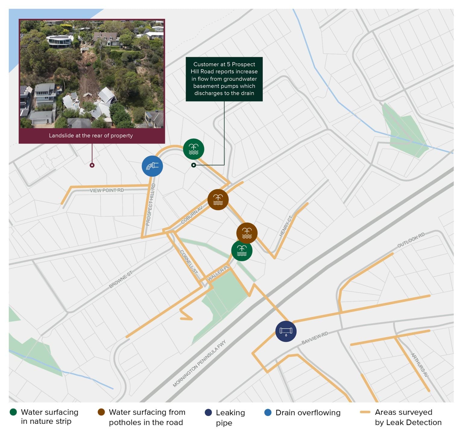
- It is obvious that in the period between 5 and 14 January 2025, SEW was actively looking for the source of water that was seen emanating from the headscarp. No criticism can be levelled against SEW for trying in that respect. But should they have done more?
- With the benefit of hindsight, reasonable minds could differ as to what approach SEW could or should have taken after the 5 January 2025 landslide. It would not be possible to interrogate all the courses of action available to SEW during those critical eight days between the landslides. However, three questions present themselves as deserving further consideration:
- Should SEW have conducted further tests and investigations to determine whether the water flowing out of the 5 January 2025 landslide site may have originated from the burst water main?
- Should SEW have informed the Shire’s MBS, and/or other appropriate representatives of the Shire, in the days between the 5 January 2025 landslide and the McCrae Landslide, about the burst water main?
- Should SEW have taken steps, together with the Shire, to try to intercept the subsurface water flow upslope of the site and to direct it away from the landslide site?
- The third question can be addressed in relatively short order. It will be dealt with first.
- SEW submitted that it could not have been expected to take steps, together with the Shire, to intercept the subsurface water flow upslope of the site. It relied on two matters. First, it submitted that, in the period between 5 and 14 January 2025, it held the reasonable view that the water had not originated from a water main given that the electrical conductivity of the water sample taken at the headscarp on 6 January 2025 was 1600 MicroSiemens per centimetre, the area was well-known for natural springs, and the burst water main was located 465 metres uphill from the headscarp. Second, it submitted that there is a ‘regulatory gap’ as no organisation is tasked with the responsibility for managing the negative consequences of groundwater, including diverting it.287
- SEW’s submission seems to begin with the premise that SEW categorically knew that the water flowing out of the escarpment was not mains water but groundwater. Such an absolute position is difficult to reconcile with the ongoing investigations conducted by SEW to locate the source of the water, even in the aftermath of the McCrae Landslide.
- The following email sent by Mr Swain to Mr Lloyd on 14 January 2025 demonstrates that final conclusions about the source and nature of the water had not yet been reached:
Over the last 10 days [that is, since the 5 January 2025 landslide] we have been working with the customers and Morn Pen Council to investigate the source of water coming out of the ground at multiple locations that has caused a land slip at 10 Viewpoint Rd, McCrae. This included leak detection of the whole area, review of pressure and flow data from trends at the zone pump station and water quality sampling of 3 of the points where water has been surfacing. We have yet to conclude these investigations, as further leak detection is currently being undertaken further north, however at this stage our investigations are concluding that the water is not from the SEW Water Network.
We did identify 2 leaks across the highway which have now been repaired but these were overflowing into the stormwater drain and not going into the ground. Once our investigations have been concluded I will be preparing a summary report of our activities and findings.288 (emphasis added)
- Again, as explained above, in circumstances where neither SEW nor the Shire could be sure that the water flowing out of the escarpment was not from their assets, they could have worked together between 5 and 14 January 2025 to try to intercept the subsurface water flow upslope of the site on View Point Road, and to direct it away from the landslide site.
- Suffice to say that had the Shire developed and implemented a comprehensive landslide response plan, it is reasonable to expect that there would have been some engagement with SEW about such an option in order to mitigate the risk of a further landslide in circumstances where neither SEW nor the Shire could be sure that the water was not coming from their assets.
- Turning now to the first and second questions. The answers to those questions depend on the state of SEW’s knowledge concerning the burst water main in the period between 5 and 14 January 2025.
- SEW submitted that during that period it did not draw a clear connection between the water flowing out of the headscarp and the burst water main which had been repaired on New Year’s Day. At that stage, SEW had no knowledge of the volume and duration of the leak.289
- What does the evidence suggest?
- It is uncontroversial that by 5 January 2025, SEW knew three things: large volumes of water had been surfacing on the streets of McCrae since November 2024; a burst water main had been located and repaired in the lead up to and on New Year’s Day; and water was flowing from the headscarp of the landslide at 10–12 View Point Road.
- Recognising each of those facts individually is one thing, but fully appreciating their interrelationship is quite another.
- Mr Marsh gave evidence that, on 6 January 2025, he did not consider that there was a link between the burst water main, the water surfacing around Waller Place and the 5 January 2025 landslide. However, he recognised that the sequence of factors did not “look good”, such that there might be a “misconception” that the landslide had been triggered by the burst water main.290
- Mr Lloyd gave evidence that, on the day of the McCrae Landslide, he had not drawn a potential link between the burst water main and the McCrae Landslide. He explained that the burst water main was “too far” away from the landslide site, both geographically and temporally. He recounted his state of mind on 14 January 2025 as follows:
The fact water was still surfacing weeks after the Burst Water Main was fixed caused me to believe the two issues [the burst water main and the cause of the McCrae Landslide] were unrelated and the focus for me and my team was on the ongoing water surfacing at various locations near the McCrae Landslide site.291
- Mr Lloyd also said:
I’m not correlating the two together at this point ... my focus was on the here and now and the fact that there was water emerging at that time.292
- He emphasised that his “genuine concern” was whether SEW had an issue in one of its pipes in the vicinity of the landslide site.293
- The contemporaneous documentary evidence does not contradict that oral evidence.
- The state of the evidence, therefore, supports a finding that, in the intervening period between the landslides, SEW did not know or strongly suspect that the burst water main was the source of the water emanating from the headscarp.
- In view of that state of knowledge, and in the absence of a Shire-led plan to respond to landslides, it is understandable why SEW did not, in the days between the 5 January 2025 landslide and the McCrae Landslide, take the following steps:
- conduct further tests and investigations to determine whether water flowing out of the 5 January 2025 landslide site may have originated from the burst water main; and
- inform the Shire’s MBS, who was leading the Shire’s response to the 5 January 2025 landslide, about the burst water main.With the benefit of hindsight, and especially with the benefit of the expert evidence, it would be easy enough to say that SEW should have taken such steps. But that would be to ignore the reality that SEW, at the relevant time, did not fully grasp the significance of the burst water main. Nor was SEW privy to the concerns of Mr Glover, Mr Rotter and Mr Pope that there was a growing risk of another landslide over the days that followed the 5 January 2025 landslide.
- Had the Shire developed and implemented a comprehensive landslide response plan, it is reasonable to expect that the level of co-ordination and information sharing between SEW and the Shire, as well as the VicSES, during those critical eight days between the landslides would have been markedly improved. While it cannot be said with certainty that such measures would have prevented the McCrae Landslide, there was a missed opportunity to lessen the likelihood of it occurring.
Chapter 6 Endnotes
- 1 Mornington Peninsula Shire Council, ‘Our Organisational Values’, About Our Organisation (Web Page) https://www.mornpen.vic.gov.au/About-Us/About-Our-Organisation/Our-Organisational-Values.
- 2 Exhibit CA-13, Second Witness Statement of David Simon, 17 April 2025, Exhibit CA-13(110) [MSC.5012.0001.4440 at .4452].
- 3 Exhibit CA-13, Second Witness Statement of David Simon, 17 April 2025, Exhibit CA-13(110) [MSC.5012.0001.4440 at .4452].
- 4 Exhibit CA-13, Second Witness Statement of David Simon, 17 April 2025, Exhibit CA-13(110) [MSC.5012.0001.4440 at .4454].
- 5 Exhibit CA-13, Second Witness Statement of David Simon, 17 April 2025, Exhibit CA-13(110) [MSC.5012.0001.4440 at .4452].
- 6 Exhibit CA-13, Second Witness Statement of David Simon, 17 April 2025, Exhibit CA-13(110) [MSC.5012.0001.4440 at .4453].
- 7 Mornington Peninsula C52 (PSA) [2003] PPV 115 at Section 4.2.
- 8 Mornington Peninsula C52 (PSA) [2003] PPV 115 at Section 4.1.
- 9 Mornington Peninsula C52 (PSA) [2003] PPV 115 at Section 4.1.
- 10 Mornington Peninsula C52 (PSA) [2003] PPV 115 at Section 4.2.
- 11 Mornington Peninsula C52 (PSA) [2003] PPV 115 at Section 2.3.
- 12 Mornington Peninsula C52 (PSA) [2003] PPV 115 at Section 4.2.
- 13 Exhibit CA-12, First Witness Statement of David Simon, 11 April 2025, Exhibit CA-12(8) [MSC.5014.0001.1302].
- 14 Exhibit CA-21, Witness Statement of Paul Willigenburg, 14 May 2025, Exhibit PW-3 [RES.0010.0001.0003].
- 15 Exhibit CA-12, First Witness Statement of David Simon, 11 April 2025, Exhibit CA-12(81) [MSC.5003.0001.0030 at .0034].
- 16 Exhibit CA-13, Second Witness Statement of David Simon, 17 April 2025, 50–51 [138].
- 17 Exhibit CA-13, Second Witness Statement of David Simon, 17 April 2025, 51 [140].
- 18 Exhibit CA-77, Revised McCrae Landslide Risk Assessment for Evacuation Area prepared by PSM, 28 May 2025, [MSC.5056.0001.0003].
- 19 Mornington Peninsula C52 (PSA) [2003] PPV 115 at Section 4.2.
- 20 Public Submission of Dr Joseph Radcliffe, 8 May 2025, [SUB.0036.0001.0001].
- 21 Exhibit CA-13, Second Witness Statement of David Simon, 17 April 2025, Exhibit CA-13(117) [MSC.5012.0001.0123 at .0140].
- 22 Exhibit CA-13, Second Witness Statement of David Simon, 17 April 2025, Exhibit CA-13(117) [MSC.5012.0001.0123 at .0127].
- 23 Email from Chloe Patching to Infrastructure Asset Notification at Mornington Peninsula Shire Council about completion of The Eyrie Gully Stabilisation Project, 10 November 2014, [MSC.5092.0001.0001].
- 24 Exhibit CA-11, Witness Statement of Bulent Oz, 11 April 2025, Exhibit CA-11(3) [MSC.5014.0001.0010], Exhibit CA-11(4) [MSC.5014.0001.0068].
- 25 Exhibit CA-13, Second Witness Statement of David Simon, 17 April 2025, Exhibit CA-13(110) [MSC.5012.0001.4440 at .4514].
- 26 Exhibit CA-11, Witness Statement of Bulent Oz, 11 April 2025, 6–7 [29]; Public Hearing Transcript, Bulent Oz, 8 May 2025, 188–189.
- 27 Department of Transport and Planning, Using Victoria’s Planning System (Guide, March 2024) https://www.planning.vic.gov.au/__data/assets/pdf_file/0033/629349/Using-Victorias-Planning-System-March-2024.pdf.
- 28 Exhibit CA-1(2), Mornington Peninsula Planning Scheme (in force prior to 5 January 2025), [INQ.0003.0001.0001 at _0755].
- 29 Exhibit CA-1(2), Mornington Peninsula Planning Scheme (in force prior to 5 January 2025), [INQ.0003.0001.0001 at _0755–_0769, _1210]; Exhibit CA-11, Witness Statement of Bulent Oz, 11 April 2025, 6–7 [29].
- 30 Exhibit CA-1(2), Mornington Peninsula Planning Scheme (in force prior to 5 January 2025), [INQ.0003.0001.0001 at _0755–_0769].
- 31 Public Hearing Transcript, David Simon, 9 May 2025, 229.
- 32 Exhibit CA-12, First Witness Statement of David Simon, 11 April 2025, 19 [47].
- 33 Exhibit CA-12, First Witness Statement of David Simon, 11 April 2025, 18–19 [44].
- 34 Exhibit CA-1(2), Mornington Peninsula Planning Scheme (in force prior to 5 January 2025), [INQ.0003.0001.0001 at _0764, _0767].
- 35 Exhibit CA-1(2), Mornington Peninsula Planning Scheme (in force prior to 5 January 2025), [INQ.0003.0001.0001 at _0764].
- 36 Exhibit CA-1(2), Mornington Peninsula Planning Scheme (in force prior to 5 January 2025), [INQ.0003.0001.0001 at _0755, _0764, _0767].
- 37 Exhibit CA-1(2), Mornington Peninsula Planning Scheme (in force prior to 5 January 2025), [INQ.0003.0001.0001 at _0764, _0767].
- 38 Exhibit CA-1(2), Mornington Peninsula Planning Scheme (in force prior to 5 January 2025), [INQ.0003.0001.0001 at _0764–_0765, _0767–_0768].
- 39 Yarra Ranges Council, ‘Erosion Management Overlay Mapping Review (Planning Scheme Amendment C225)’, Amendment C225 Erosion Management Overlay Mapping Review (Fact Sheet, August 2025) <https://www.yarraranges.vic.gov.au/Our-services/Planning-building-and-development/Planning/Amendments-to-the-planning-scheme/Amendment-C225-Erosion-Management-Overlay-Mapping-Review>.
- 40 Exhibit CA-11, Witness Statement of Bulent Oz, 11 April 2025, 6–7 [29]; Public Hearing Transcript, Bulent Oz, 8 May 2025, 188–189.
- 41 Public Hearing Transcript, Bulent Oz, 8 May 2025, 201.
- 42 Public Hearing Transcript, Katanya Barlow, 20 June 2025, 791.
- 43 Public Hearing Transcript, David Simon, 9 May 2025, 232.
- 44 Exhibit CA-12, First Witness Statement of David Simon, 11 April 2025, Exhibit CA-12(65) [MSC.5014.0001.0182 at .0386].
- 45 Exhibit CA-12, First Witness Statement of David Simon, 11 April 2025, Exhibit CA-12(65) [MSC.5014.0001.0182 at .0205].
- 46 Exhibit CA-12, First Witness Statement of David Simon, 11 April 2025 19 [48]–[49]; Exhibit CA-12, First Witness Statement of David Simon, 11 April 2025, Exhibit CA-12(65) [MSC.5014.0001.0182 at .0387].
- 47 Exhibit CA-13, Second Witness Statement of David Simon, 17 April 2025, 37 [76].
- 48 Exhibit CA-13, Second Witness Statement of David Simon, 17 April 2025, Exhibit CA-13(110) [MSC.5012.0001.4440 at .4531–.4532].
- 49 Exhibit CA-13, Second Witness Statement of David Simon, 17 April 2025, Exhibit CA-13(110) [MSC.5012.0001.4440 at .4532].
- 50 Public Hearing Transcript, David Simon, 9 May 2025, 237.
- 51 Exhibit CA-13, Second Witness Statement of David Simon, 17 April 2025, 37 [77].
- 52 Exhibit CA-11, Witness Statement of Bulent Oz, 11 April 2025, 9 [43]; Exhibit CA-13, Second Witness Statement of David Simon, 17 April 2025, 35 [63].
- 53 Exhibit CA-11, Witness Statement of Bulent Oz, 11 April 2025, 9 [44].
- 54 Exhibit CA-11, Witness Statement of Bulent Oz, 11 April 2025, 9 [45].
- 55 Exhibit CA-11, Witness Statement of Bulent Oz, 11 April 2025, 9 [46].
- 56 Public Hearing Transcript, David Simon, 9 May 2025, 244.
- 57 Public Hearing Transcript, David Simon, 9 May 2025, 243.
- 58 Exhibit CA-13, Second Witness Statement of David Simon, 17 April 2025, Exhibit CA-13(111) [MSC.5005.0044.5961].
- 59 Adapted from Exhibit CA-13, Second Witness Statement of David Simon, 17 April 2025, Exhibit CA-13(66), [MSC.5005.0044.5961 at .5964].
- 60 Exhibit CA-13, Second Witness Statement of David Simon, 17 April 2025, Exhibit CA-13(111) [MSC.5005.0044.5961 at .5963].
- 61 Exhibit CA-13, Second Witness Statement of David Simon, 17 April 2025, Exhibit CA-13(111) [MSC.5005.0044.5961 at .5965].
- 62 Exhibit CA-13, Second Witness Statement of David Simon, 17 April 2025, 35–36 [67].
- 63 Exhibit CA-11, Witness Statement of Bulent Oz, 11 April 2025, 9 [44].
- 64 Public Hearing Transcript, David Simon, 9 May 2025, 253.
- 65 Public Hearing Transcript, David Simon, 9 May 2025, 229.
- 66 Public Hearing Transcript, David Simon, 9 May 2025, 224–226.
- 67 Public Hearing Transcript, David Simon, 9 May 2025, 225–226.
- 68 Exhibit CA-31, Third Witness Statement of David Smith, 11 June 2025, 9 [39].
- 69 Exhibit CA-31, Third Witness Statement of David Smith, 11 June 2025, 9 [39].
- 70 Public Hearing Transcript, David Smith, 20 June 2025, 704.
- 71 Exhibit CA-31, Third Witness Statement of David Smith, 11 June 2025, 10 [40].
- 72 Exhibit CA-31, Third Witness Statement of David Smith, 11 June 2025, 10 [42].
- 73 Exhibit CA-31, Third Witness Statement of David Smith, 11 June 2025, 10 [43].
- 74 Public Hearing Transcript, David Smith, 20 June 2025, 719.
- 75 Public Hearing Transcript, David Smith, 20 June 2025, 719–720.
- 76 Public Hearing Transcript, David Smith, 20 June 2025, 721.
- 77 Public Hearing Transcript, David Smith, 20 June 2025, 722.
- 78 Exhibit CA-80, Fifth Witness Statement of David Simon, 11 June 2025, 2–3 [1]–[2].
- 79 Exhibit CA-79, Fourth Witness Statement of David Simon, 11 June 2025, 4 [11].
- 80 Public Hearing Transcript, David Simon, 9 May 2025, 255.
- 81 Public Hearing Transcript, David Simon, 9 May 2025, 255.
- 82 Exhibit CA-12, First Witness Statement of David Simon, 11 April 2025, Exhibit CA-12(96) [MSC.5007.0003.0088], Exhibit CA-12(92) [MSC.5007.0003.0815].
- 83 Exhibit CA-32, Witness Statement of Claudio Flores, 22 May 2025, Exhibit CA-32(6) [MSC.5007.0003.0804].
- 84 Exhibit CA-32, Witness Statement of Claudio Flores, 22 May 2025, 5 [21].
- 85 Exhibit CA-11, Witness Statement of Bulent Oz, 11 April 2025, 6 [29].
- 86 Exhibit CA-12, First Witness Statement of David Simon, 11 April 2025, 19 [51]; Exhibit CA-12, First Witness Statement of David Simon, 11 April 2025, Exhibit CA-12(66) [MSC.5014.0001.0532 at .0545].
- 87 Exhibit CA-12, First Witness Statement of David Simon, 11 April 2025, Exhibit CA-12(66) [MSC.5014.0001.0532 at .0541].
- 88 Exhibit CA-12, First Witness Statement of David Simon, 11 April 2025, Exhibit CA-12(66) [MSC.5014.0001.0532 at .0627].
- 89 Public Hearing Transcript, David Simon, 9 May 2025, 240–241.
- 90 Exhibit CA-12, First Witness Statement of David Simon, 11 April 2025, Exhibit CA-12(66) [MSC.5014.0001.0532 at .0664].
- 91 Exhibit CA-13, Second Witness Statement of David Simon, 17 April 2025, 38 [79].
- 92 Mornington Peninsula Shire, ‘Our Organisational Values’, About Our Organisation (Web Page) https://www.mornpen.vic.gov.au/About-Us/About-Our-Organisation/Our-Organisational-Values.
- 93 Mornington Peninsula Shire Council, Response to first set of potential adverse findings, 21 August 2025, [MSC.5094.0001.0020].
- 94 Letter from Mornington Peninsula Shire Council's solicitors to Solicitors Assisting the Board of Inquiry about requests for further information from July 2025, 2 September 2025, [INQ.0014.0001.0001 at _0002].
- 95 Exhibit CA-13, Second Witness Statement of David Simon, 17 April 2025, 44 [114]–[117].
- 96 Mornington Peninsula Shire Council, Response to second set of potential adverse findings, 25 August 2025, [MSC.5094.0001.0029].
- 97 Public Hearing Transcript, Claudio Flores, 20 June 2025, 752–756, 758.
- 98 Exhibit CA-32, Witness Statement of Claudio Flores, 22 May 2025, 3 [7(a)].
- 99 Exhibit CA-32, Witness Statement of Claudio Flores, 22 May 2025, 3 [7(b)].
- 100 Exhibit CA-32, Witness Statement of Claudio Flores, 22 May 2025, 3 [7(c)].
- 101 Exhibit CA-32, Witness Statement of Claudio Flores, 22 May 2025, 3 [7(a)].
- 102 Borghesi v Municipal Building Surveyor for the Shire of Mornington Peninsula [2025] VBAB 60.
- 103 Mornington Peninsula Shire Council, Response to second set of potential adverse findings, 25 August 2025, [MSC.5094.0001.0029].
- 104 Exhibit CA-11, Witness Statement of Bulent Oz, 11 April 2025, Exhibit CA-11(9) [MSC.5007.0001.1278 at _1328].
- 105 Exhibit CA-11, Witness Statement of Bulent Oz, 11 April 2025, Exhibit CA-11(9) [MSC.5007.0001.1278 at _1291].
- 106 Exhibit CA-11, Witness Statement of Bulent Oz, 11 April 2025, 10 [49], [51].
- 107 Exhibit CA-11, Witness Statement of Bulent Oz, 11 April 2025, Exhibit CA-11(6) [MSC.5006.0001.1021 at .1027].
- 108 Emergency Management Victoria, ‘Role statement – Councils’, Councils (Web Page, 29 November 2024) <https://www.emv.vic.gov.au/responsibilities/state-emergency-management-plan-semp/roles-and-responsibilities/role-statements/role-statement-councils>.
- 109 Mornington Peninsula Shire Council, Response to second set of potential adverse findings, 25 August 2025, [MSC.5094.0001.0029].
- 110 Exhibit CA-55, Witness Statement of Mark Stoermer, 13 June 2025, 5 [11]–[12].
- 111 Public Hearing Transcript, Katanya Barlow, 20 June 2025, 792–798; Exhibit CA-55, Witness Statement of Mark Stoermer, 13 June 2025, 8–9 [19(b)].
- 112 Public Hearing Transcript, David Smith, 20 June 2025, 701–702, 711, 713–715.
- 113 Public Hearing Transcript, David Smith, 20 June 2025, 734–736.
- 114 Public Hearing Transcript, David Smith, 20 June 2025, 729–730.
- 115 Mornington Peninsula Shire Council, Response to second set of potential adverse findings, 25 August 2025, [MSC.5094.0001.0029].
- 116 For the avoidance of doubt, the term “response” in this section is used in its ordinary sense. It is not intended to bear the particular meaning it has under the SEMP, unless otherwise indicated.
- 117 Mornington Peninsula Shire Council, Response to second set of potential adverse findings, 25 August 2025, [MSC.5094.0001.0029].
- 118 Exhibit CA-11, Witness Statement of Bulent Oz, 11 April 2025, 10 [52].
- 119 Exhibit CA-11, Witness Statement of Bulent Oz, 11 April 2025, 11 [58].
- 120 Exhibit CA-11, Witness Statement of Bulent Oz, 11 April 2025, 15–16 [82]–[87].
- 121 Exhibit CA-11, Witness Statement of Bulent Oz, 11 April 2025, Exhibit CA-11(14) [MSC.5004.0001.0059].
- 122 Mornington Peninsula Shire Council, Response to second set of potential adverse findings, 25 August 2025, [MSC.5094.0001.0029] referring to Exhibit CA-31, Second Witness Statement of David Smith, 30 April 2025, 2–3 [4]–[7].
- 123 Exhibit CA-31, First Witness Statement of David Smith, 17 April 2025, 9.
- 124 Exhibit CA-31, First Witness Statement of David Smith, 17 April 2025, Exhibit CA-31(13) [MSC.5018.0001.0021 at .0022].
- 125 Exhibit SEW-2, South East Water Montage Records, 1 November 2024–31 January 2025, [SEW.0001.0001.0085]; Screenshot of Facebook Post on McCrae Village Community Group page, 21 December 2024, [MSC.5035.0001.0025].
- 126 Exhibit CA-31, Second Witness Statement of David Smith, 30 April 2025, 13 [44].
- 127 Exhibit CA-17, Witness Statement of Brett Phillip Cooper, 12 May 2025, 8 [29(b)].
- 128 Public Hearing Transcript, Brett Phillip Cooper, 12 May 2025, 347.
- 129 Public Hearing Transcript, Brett Phillip Cooper, 12 May 2025, 347.
- 130 Exhibit CA-61, First Witness Statement of Mathew Hopwood-Glover, 27 June 2025, 3 [6].
- 131 Exhibit CA-61, First Witness Statement of Mathew Hopwood-Glover, 27 June 2025, 3 [8].
- 132 Exhibit CA-22, Witness Statement of Gerrard Raymond Borghesi, 14 May 2025, Exhibit GB-1 [RES.0001.0003.0001 at _0032–_0036]; Public Hearing Transcript, Claudio Flores, 20 June 2025, 773–774; Exhibit CA-64, Third Witness Statement of Mathew Hopwood-Glover, 23 July 2025, Exhibit CA-64(3) [MSC.5005.0042.2288 at .2288].
- 133 Exhibit CA-64, Third Witness Statement of Mathew Hopwood-Glover, 23 July 2025, 8–9 [27].
- 134 Exhibit CA-61, First Witness Statement of Mathew Hopwood-Glover, 27 June 2025, 3 [10].
- 135 Public Hearing Transcript, Claudio Flores, 20 June 2025, 773–774; Email from Claudio Flores to Dane Pope and Mathew Hopwood-Glover about use of plumber’s dye in stormwater pits near 10–12 View Point Road, 7 January 2025, [MSC.5001.0001.1553]; Exhibit CA-61, First Witness Statement of Mathew Hopwood-Glover, 27 June 2025, 6–7 [23].
- 136 Exhibit CA-64, Third Witness Statement of Mathew Hopwood-Glover, 23 July 2025, 12–13 [42]; Exhibit CA-15, First Witness Statement of Kellie Anne Moran, 12 May 2025, Exhibit KM-3 [RES.0009.0001.0005].
- 137 Exhibit CA-61, First Witness Statement of Mathew Hopwood-Glover, 27 June 2025, 5 [18]; Exhibit CA-16, First Witness Statement of Nicholas James Moran, 12 May 2025, 12 [59].
- 138 RACV file notes relating to claim of Nicholas Moran at 3 Penny Lane, 5 January 2025–4 March 2025, [IMA.0001.0001.0188 at _0013].
- 139 Exhibit CA-64, Third Witness Statement of Mathew Hopwood-Glover, 23 July 2025, 14 [52].
- 140 Exhibit CA-64, Third Witness Statement of Mathew Hopwood-Glover, 23 July 2025, 2 [5].
- 141 Exhibit CA-64, Third Witness Statement of Mathew Hopwood-Glover, 23 July 2025, 3 [6].
- 142 Exhibit CA-54, Witness Statement of David Kotsiakos, 13 June 2025, 5 [12].
- 143 Exhibit CA-54, Witness Statement of David Kotsiakos, 13 June 2025, 5 [13].
- 144 Exhibit CA-64, Third Witness Statement of Mathew Hopwood-Glover, 23 July 2025, 14 [51].
- 145 Exhibit CA-64, Third Witness Statement of Mathew Hopwood-Glover, 23 July 2025, 15 [55(h)].
- 146 Borghesi v Municipal Building Surveyor for the Shire of Mornington Peninsula [2025] VBAB 60.
- 147 Exhibit CA-14, Third Witness Statement of David Simon, 7 May 2025, 3 [7].
- 148 Exhibit CA-14, Third Witness Statement of David Simon, 7 May 2025, 3 [7].
- 149 Exhibit CA-62, Witness Statement of Andrew Brick, 16 July 2025, 6 [22].
- 150 Exhibit CA-14, Third Witness Statement of David Simon, 7 May 2025, 4 [8].
- 151 Exhibit CA-63, Second Witness Statement of Mathew Hopwood-Glover, 17 July 2025, 2 [5].
- 152 Exhibit CA-63, Second Witness Statement of Mathew Hopwood-Glover, 17 July 2025, 2–3 [5]; Exhibit CA11, Witness Statement of Bulent Oz, 11 April 2025, Exhibit CA-11(9) [MSC.5007.0001.1278 at .1338].
- 153 Exhibit CA-63, Second Witness Statement of Mathew Hopwood-Glover, 17 July 2025, 3 [6(b)].
- 154 Exhibit CA-63, Second Witness Statement of Mathew Hopwood-Glover, 17 July 2025, 3–4 [7].
- 155 Email from Mathew Hopwood-Glover to Renae Littlejohn and Rory MacDonald about landslip impact at 10–12 View Point Road, 6 January 2025, [MSC.5005.0042.0892].
- 156 Exhibit CA-13, Second Witness Statement of David Simon, 17 April 2025, Exhibit CA-13(121) [MSC.5003.0001.7156].
- 157 Exhibit CA-64, Third Witness Statement of Mathew Hopwood-Glover, 23 July 2025, Exhibit CA-64(3) [MSC.5005.0042.2288 at .2291–.2292].
- 158 Exhibit CA-13, Second Witness Statement of David Simon, 17 April 2025, Exhibit CA-13(1) [MSC.5005.0042.1513].
- 159 Email from Mathew Hopwood-Glover to Renae Littlejohn, Rory MacDonald and Claudio Flores et al about mitigating the risk of further landslide activity, 8 January 2025, [MSC.5003.0001.7185].
- 160 Exhibit CA-64, Third Witness Statement of Mathew Hopwood-Glover, 23 July 2025, Exhibit CA-64(3) [MSC.5005.0042.2288 at .2291].
- 161 Exhibit CA-64, Third Witness Statement of Mathew Hopwood-Glover, 23 July 2025, Exhibit CA-64(3) [MSC.5005.0042.2288 at .2291].
- 162 Exhibit CA-64, Third Witness Statement of Mathew Hopwood-Glover, 23 July 2025, Exhibit CA-64(3) [MSC.5005.0042.2288 at .2289].
- 163 Exhibit CA-64, Third Witness Statement of Mathew Hopwood-Glover, 23 July 2025, Exhibit CA-64(3) [MSC.5005.0042.2288 at .2288–.2290].
- 164 Exhibit CA-64, Third Witness Statement of Mathew Hopwood-Glover, 23 July 2025, Exhibit CA-64(3) [MSC.5005.0042.2288 at .2288].
- 165 Email from Mathew Hopwood-Glover to David Smith, Tom Haines-Sutherland, Renae Littlejohn and Rory MacDonald about OMBS preliminary assessment of leak, 13 January 2025, [MSC.5005.0042.2737].
- 166 Exhibit CA-64, Third Witness Statement of Mathew Hopwood-Glover, 23 July 2025, Exhibit CA-64(3) [MSC.5005.0042.2288 at .2289].
- 167 Mornington Peninsula Shire, ‘Our Organisational Values’, About Our Organisation (Web Page) https://www.mornpen.vic.gov.au/About-Us/About-Our-Organisation/Our-Organisational-Values.
- 168 Public Hearing Transcript, Kellie Anne Moran, 12 May 2025, 269.
- 169 Exhibit CA-16, First Witness Statement of Nicholas James Moran, 12 May 2025, 8 [38].
- 170 Exhibit CA-13, Second Witness Statement of David Simon, 17 April 2025, Exhibit CA-13(121) [MSC.5003.0001.7156].
- 171 Public Hearing Transcript, Claudio Flores, 20 June 2025, 774.
- 172 Exhibit CA-22, Witness Statement of Gerrard Raymond Borghesi, 14 May 2025, Exhibit GB-1 [RES.0001.0003.0001 at _0040].
- 173 Exhibit CA-64, Third Witness Statement of Mathew Hopwood-Glover, 23 July 2025, Exhibit CA-64(3) [MSC.5005.0042.2288 at .2289-.2290].
- 174 Email from Mathew Hopwood-Glover to Dane Pope attaching photos taken at 10–12 View Point Road, 10 January 2025, [MSC.5005.0042.2452 at .2463].
- 175 Exhibit CA-16, First Witness Statement of Nicholas James Moran, 12 May 2025, 12 [63].
- 176 Exhibit CA-19, Witness Statement of John Nicholas Bolch, 14 May 2025, 4 [17].
- 177 Midcity, Summary of works completed by Midcity at 3 Penny Lane, 5–14 January 2025, [IMA.0001.0001.0078 at _0001].
- 178 Mark Finningham, Midcity, Expert Report about damage incurred at 3 Penny Lane, 7 January 2025, [IMA.0001.0001.0320 at _0001].
- 179 Public Hearing Transcript, Gerrard Raymond Borghesi, 15 May 2025, 529.
- 180 Exhibit CA-22, Witness Statement of Gerrard Raymond Borghesi, 14 May 2025, Exhibit GB-1 [RES.0001.0003.0001 at _0035].
- 181 Exhibit CA-22, Witness Statement of Gerrard Raymond Borghesi, 14 May 2025, Exhibit GB-1 [RES.0001.0003.0001 at _0040].
- 182 Public Hearing Transcript, Gerrard Raymond Borghesi, 15 May 2025, 529.
- 183 Text message chain between Mathew Hopwood-Glover and Dane Pope regarding site visit conducted at 10–12 View Point Road, 6–13 January 2025, [MSC.5031.0001.6040].
- 184 Exhibit CA-62, Witness Statement of Andrew Brick, 16 July 2025, 4–5 [14].
- 185 Emergency Management Act 2013 (Vic) s 3; Victoria State Emergency Service, State Landslide Hazard Plan (Version 1, September 2018) 10.
- 186 Exhibit CA-67, McCrae Landslide Causation Report prepared by WSP, 21 July 2025, [DPA.0004.0001.0001 at _0108–_0112.
- 187 Exhibit CA-61, First Witness Statement of Mathew Hopwood-Glover, 27 June 2025, 3-4 [12]; Exhibit CA-61, First Witness Statement of Mathew Hopwood Glover, 27 June 2025, Exhibit CA-61(1) [MSC.5003.0001.7180].
- 188 Exhibit CA-16, First Witness Statement of Nicholas James Moran, 12 May 2025, 8 [39].
- 189 Exhibit CA-61, First Witness Statement of Mathew Hopwood-Glover, 27 June 2025, 7–8 [27].
- 190 Public Hearing Transcript, Nicholas James Moran, 12 May 2025, 321.
- 191 Exhibit CA-38, Email from Jason Marsh to Charles Swain about inspection of landslide site and sampling, 6 January 2025, [SEW.0001.0001.0454].
- 192 Exhibit CA-61, First Witness Statement of Mathew Hopwood-Glover, 27 June 2025, 6–7 [23], 7–8 [27].
- 193 Public Hearing Transcript, Gerrard Raymond Borghesi, 15 May 2025, 536.
- 194 Public Hearing Transcript, Gerrard Raymond Borghesi, 15 May 2025, 536.
- 195 Exhibit CA-67, McCrae Landslide Causation Report prepared by WSP, 21 July 2025, [DPA.0004.0001.0001 at _0111–_0112].
- 196 Public Hearing Transcript, Gerrard Raymond Borghesi, 15 May 2025, 536.
- 197 Exhibit CA-61, First Witness Statement of Mathew Hopwood-Glover, 27 June 2025, 2 [4]–[5].
- 198 Public Hearing Transcript, Chairperson, 7 May 2025, 4.
- 199 Minutes of McCrae Strategy Group, 28 February 2025, [SEW.0001.0001.2493].
- 200 Minutes of McCrae Strategy Group, 28 February 2025, [SEW.0001.0001.2493].
- 201 Minutes of McCrae Strategy Group, 27 March 2025 [SEW.0001.0001.2503 at _0002].
- 202 Minutes of McCrae Strategy Group, 7 April 2025, [SEW.0001.0001.2577].
- 203 Exhibit CA-28, Email chain between Charles Swain, Declan McCreesh and Gary Loudon et al about burst in Bayview Road, 3 February 2025, [SEW.0001.0001.0036 at _0002].
- 204 Exhibit CA-76, Report about Flow Rate from a Longitudinal Split in PVC Pipe prepared by Dr Jakobus E van Zyl and Dr Andrew Brown, 17 July 2025, [SEW.0001.0002.4191 at _0011–_0012].
- 205 Public Submission of McCrae Resident, 4 May 2025, [SUB.0032.0001.0001]; Exhibit CA-17, Witness Statement of Brett Phillips Cooper, 12 May 2025, 1 [4]–[5]; Public Hearing Transcript, Brett Phillips Cooper, 12 May 2025, 328–329.
- 206 South East Water, Response to first set of potential adverse findings, 21 August 2025, [SEW.0001.0002.4203].
- 207 Public Hearing Transcript, Tim Lloyd, 23 June 2025, 849.
- 208 Exhibit CA-76, Report about Flow Rate from a Longitudinal Split in PVC Pipe prepared by Dr Jakobus E van Zyl and Dr Andrew Brown, 17 July 2025, [SEW.0001.0002.4191 at _0012].
- 209 Public Hearing Transcript, Lara Olsen, 16 May 2025, 588.
- 210 Public Hearing Transcript, Lara Olsen, 16 May 2025, 589.
- 211 Public Hearing Transcript, Lara Olsen, 16 May 2025, 589.
- 212 Public Hearing Transcript, Lara Olsen, 16 May 2025, 589–590.
- 213 Public Hearing Transcript, Lara Olsen, 16 May 2025, 590.
- 214 Exhibit CA-25, Witness Statement of Lara Olsen, 16 May 2025, 8 [41].
- 215 Public Hearing Transcript, Lara Olsen, 16 May 2025, 593.
- 216 Public Hearing Transcript, Lara Olsen, 16 May 2025, 596.
- 217 Public Hearing Transcript, Lara Olsen, 16 May 2025, 670.
- 218 Public Hearing Transcript, Andrew Forster-Knight, 24 June 2025, 1033.
- 219 Exhibit CA-25, Witness Statement of Lara Olsen, 16 May 2025, 3 [15]; Exhibit CA-35, Second Witness Statement of Tim Lloyd, 10 June 2025, 8 [46].
- 220 Public Hearing Transcript, Andrew Forster-Knight, 24 June 2025, 1013.
- 221 Public Hearing Transcript, Andrew Forster-Knight, 24 June 2025, 1033.
- 222 Public Hearing Transcript, Andrew Forster-Knight, 24 June 2025, 1033.
- 223 Public Hearing Transcript, Lara Olsen, 16 May 2025, 592.
- 224 South East Water, Response to first set of potential adverse findings, 21 August 2025, [SEW.0001.0002.4203].
- 225 Exhibit CA-76, Report about Flow Rate from a Longitudinal Split in PVC Pipe prepared by Dr Jakobus E van Zyl and Dr Andrew Brown, 17 July 2025, [SEW.0001.0002.4191 at _0032].
- 226 Exhibit CA-42, Witness Statement of Andrew Forster-Knight, 24 June 2025, 8 [42].
- 227 Public Hearing Transcript, Lara Olsen, 16 May 2025, 626.
- 228 Public Hearing Transcript, Lara Olsen, 16 May 2025, 569.
- 229 Public Hearing Transcript, Lara Olsen, 16 May 2025, 616.
- 230 Exhibit CA-76, Report about Flow Rate from a Longitudinal Split in PVC Pipe prepared by Dr Jakobus E van Zyl and Dr Andrew Brown, 17 July 2025, [SEW.0001.0002.4191].
- 231 South East Water, Response to first set of potential adverse findings, 21 August 2025, [SEW.0001.0002.4203].
- 232 South East Water, Response to first set of potential adverse findings, 21 August 2025, [SEW.0001.0002.4203].
- 233 Exhibit CA-35, Second Witness Statement of Tim Lloyd, 10 June 2025, 2 [6]–[7].
- 234 Exhibit CA-35, Second Witness Statement of Tim Lloyd, 10 June 2025, 6 [36].
- 235 Exhibit CA-35, Second Witness Statement of Tim Lloyd, 10 June 2025, 8 [46].
- 236 Exhibit CA-35, Second Witness Statement of Tim Lloyd, 10 June 2025, 8–9 [52]–[54].
- 237 Exhibit CA-35, Second Witness Statement of Tim Lloyd, 10 June 2025, 3 [13]–[15].
- 238 Exhibit CA-35, Second Witness Statement of Tim Lloyd, 10 June 2025, 4 [18]–[19].
- 239 Exhibit CA-35, Second Witness Statement of Tim Lloyd, 10 June 2025, 4–5 [23]–[24].
- 240 Public Hearing Transcript, Darren Paul, 7 May 2025, 94.
- 241 Exhibit CA-35, First Witness Statement of Tim Lloyd, 4 June 2025, Exhibit 2, [SEW.0001.0001.4896].
- 242 Public Hearing Transcript, Lara Olsen, 15 May 2025, 580.
- 243 Exhibit CA-9, South East Water Submission to the Board of Inquiry into the McCrae Landslide, April 2025, [SEW.0001.0001.0111 at _0006].
- 244 Exhibit CA-35, Second Witness Statement of Tim Lloyd, 10 June 2025, 5 [27].
- 245 Exhibit CA-35, First Witness Statement of Tim Lloyd, 4 June 2025, 4 [19].
- 246 Exhibit CA-35, Second Witness Statement of Tim Lloyd, 10 June 2025, 4 [22].
- 247 Exhibit CA-35, Second Witness Statement of Tim Lloyd, 10 June 2025, 6 [30].
- 248 Public Hearing Transcript, Jason Marsh, 23 June 2025, 909.
- 249 Public Hearing Transcript, Jason Marsh, 23 June 2025, 909.
- 250 Exhibit CA-37, Witness Statement of Jason Marsh, 4 June 2025, 2 [5].
- 251 South East Water, Response to first set of potential adverse findings, 21 August 2025, [SEW.0001.0002.4203].
- 252 Exhibit CA-35, Second Witness Statement of Tim Lloyd, 10 June 2025, 7 [44].
- 253 Public Hearing Transcript, Tim Lloyd, 23 June 2025, 813.
- 254 Public Hearing Transcript, Tim Lloyd, 23 June 2025, 823.
- 255 Public Hearing Transcript, Tim Lloyd, 23 June 2025, 826.
- 256 South East Water, Response to first set of potential adverse findings, 21 August 2025, [SEW.0001.0002.4203].
- 257 South East Water, Response to first set of potential adverse findings, 21 August 2025, [SEW.0001.0002.4203].
- 258 Exhibit CA-51, Witness Statement of Christopher Smith, 6 June 2025, 3 [13].
- 259 Exhibit CA-51, Witness Statement of Christopher Smith, 6 June 2025, 3–4 [18]–[20].
- 260 South East Water, Response to first set of potential adverse findings, 21 August 2025, [SEW.0001.0002.4203].
- 261 Exhibit CA-35, Second Witness Statement of Tim Lloyd, 10 June 2025, 3 [16].
- 262 Exhibit CA-35, Second Witness Statement of Tim Lloyd, 10 June 2025, Exhibit 2 [SEW.0001.0001.4896 at _0002].
- 263 Exhibit SEW-2, South East Water Montage Records, 1 November 2024–31 January 2025, [SEW.0001.0001.0085].
- 264 Exhibit SEW-2, South East Water Montage Records, 1 November 2024–31 January 2025, [SEW.0001.0001.0085 at _0013].
- 265 Exhibit SEW-2, South East Water Montage Records, 1 November 2024–31 January 2025, [SEW.0001.0001.0076].
- 266 Exhibit SEW-2, South East Water Montage Records, 1 November 2024–31 January 2025, [SEW.0001.0001.0076 at _0010].
- 267 Public Hearing Transcript, Lara Olsen, 16 May 2025, 593.
- 268 South East Water, Response to first set of potential adverse findings, 21 August 2025, [SEW.0001.0002.4203].
- 269 Exhibit CA-69, Revised Multidisciplinary Expert Supplementary Report about McCrae Landslide prepared by SMEC, 30 July 2025, [SME.0001.0001.0501 at _0297].
- 270 Exhibit CA-27, Multidisciplinary Expert Report about McCrae Landslide Project prepared by SMEC, 5 May 2025, [SEW.0001.0001.0142 at _0075].
- 271 Public Hearing Transcript, Tim Lloyd, 23 June 2025, 846–867.
- 272 Public Hearing Transcript, Tim Lloyd, 23 June 2025, 813.
- 273 Public Hearing Transcript, Andrew Forster-Knight, 24 June 2025, 1037.
- 274 Public Hearing Transcript, Andrew Forster-Knight, 24 June 2025, 1038.
- 275 South East Water, Response to first set of potential adverse findings, 21 August 2025, [SEW.0001.0002.4203].
- 276 South East Water, Response to first set of potential adverse findings, 21 August 2025, [SEW.0001.0002.4203].
- 277 Public Hearing Transcript, Tim Lloyd, 23 June 2025, 851.
- 278 Public Hearing Transcript, Tim Lloyd, 23 June 2025, 851.
- 279 Public Hearing Transcript, Tim Lloyd, 23 June 2025, 851–852.
- 280 State Emergency Service, Emergency call log in relation to 3 Penny Lane, 5–6 January 2025, [SES.0001.0002.0009 at _0011]; South East Water, Task Summary of Planned Maintenance Repair at 3 Penny Lane, 5 January 2025, [SEW.0001.0001.0127].
- 281 Exhibit CA-38, Email from Jason Marsh to Charles Swain about inspection of landslide site and sampling, 6 January 2025, [SEW.0001.0001.0454].
- 282 Exhibit CA-38, Email from Jason Marsh to Charles Swain about inspection of landslide site and sampling, 6 January 2025, [SEW.0001.0001.0454].
- 283 South East Water, Task Summary of Planned Maintenance Repair at 3 Penny Lane, 5 January 2025, [SEW.0001.0001.0127].
- 284 South East Water, Task Summary of Planned Maintenance Repair at 3 Penny Lane, 5 January 2025, [SEW.0001.0001.0127].
- 285 Comments from Charles Swain of South East Water about site visit to 10–12 View Point Road, 7 January 2025, [SEW.0001.0001.0731]; Email from Jason Marsh to Charles Swain et al about monitoring of storm drains and sounding services around Waller Place and Bayview Road, 9 January 2025, [SEW.0001.0001.0438].
- 286 Exhibit CA-36, Schematic of the water network in the McCrae area annotated by Charles Swain, 14 January 2025, [SEW.0001.0001.0027].
- 287 South East Water, Response to first set of potential adverse findings, 21 August 2025, [SEW.0001.0002.4203].
- 288 Exhibit CA-35, First Witness Statement of Tim Lloyd, 4 June 2025, Exhibit 4 [SEW.0001.0001.4907].
- 289 South East Water, Response to first set of potential adverse findings, 21 August 2025, [SEW.0001.0002.4203].
- 290 Public Hearing Transcript, Jason Marsh, 23 June 2025, 936.
- 291 Exhibit CA-35, First Witness Statement of Tim Lloyd, 4 June 2025, 6 [26].
- 292 Public Hearing Transcript, Tim Lloyd, 23 June 2025, 866.
- 293 Public Hearing Transcript, Tim Lloyd, 23 June 2025, 866.
Updated