

5.1 Introduction
- Having identified the cause of the McCrae Landslide, it is now time to consider the measures required to mitigate the risk of similar landslide events occurring along the escarpment at 6 and 10–12 View Point Road, and more broadly across McCrae.
- The Board of Inquiry has been assisted in relation to the first aspect by expert witnesses, Mr Paul and Mr Pope. They independently provided design concepts to the process of the Board of Inquiry at mitigation and/or remediation. The Board of Inquiry also had the benefit of a report from CivilTest, provided by Mr and Mrs Borghesi, and a report from AS James, provided by Mr and Mrs Willigenburg, in relation to the November 2022 landslides.
- In addition to considering steps that could be taken along the escarpment to mitigate further landslides, Mr Paul also considered infrastructure changes that could be implemented in McCrae more broadly to reduce the risk of landslides.
5.2 The escarpment at 6 and 10–12 View Point Road
The location of the landslides and the state of the escarpment
- It is convenient only to begin by briefly identifying the location of the landslides in 2022 and 2025. The November 2022 landslides occurred in the west gully of 10–12 View Point Road, while the 5 January 2025 landslide and the McCrae Landslide occurred in the east gully overlapping 6 and 10–12 View Point Road.
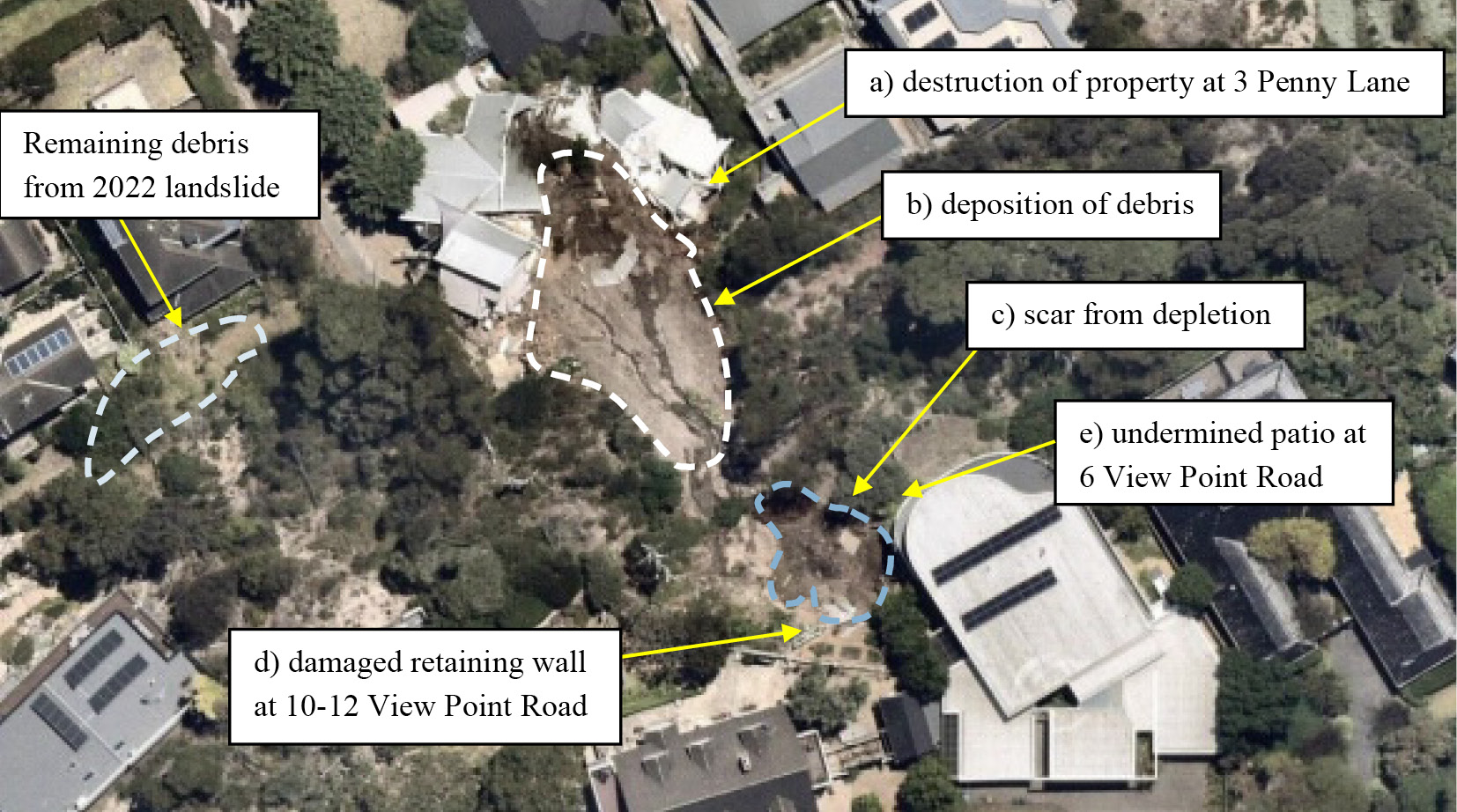
- This aerial photograph usefully depicts the location of the landslides:
FIGURE 5.1: IMAGE DEPICTING THE IMPACT OF THE LANDSLIDES AT 10–12 VIEW POINT ROAD.1
FIGURE 5.1

- The remaining debris from the November 2022 landslides can be observed to the rear of Mr and Mrs Willigenburg’s home at the toe of the escarpment. The debris flow from those landslides as depicted in the photograph, was confined to the west gully, and it ran across what was formerly the continuation of Penny Lane.
- The extent and location of the January 2025 landslides, as well as their impact on Mr and Mrs Moran’s home at 3 Penny Lane, are readily apparent in the photograph. Debris from the landslide is scattered throughout the building rubble. Approximately 300 cubic metres of soil was evacuated downhill.2 The home was propelled downward to the rear of 607-609 Point Nepean Road.
- Mr Paul and Mr Pope have considered the current condition of the landside site and separately developed design concepts to mitigate the risk of further landslides. A common element in both designs is the initial step of clearing debris from 3 Penny Lane before any work proceeds.3 Where the two concepts differ is in their approach to remediation. Mr Paul’s design is more sophisticated, as it seeks not only to mitigate the risk of future landslides but also to repair the damage to the escarpment caused by the landslides.
- The difference between mitigation and remediation should be briefly explained.
Mitigation and remediation
- Mr Paul and Mr Pope agree that mitigation works are aimed at placing the slope in a condition where the prospect of a further landslide is reduced to an acceptable level.4 The risk of another landslide can never be eliminated altogether, but mitigation works aim to make the prospect of such an event less likely. For example, Mr Paul and Mr Pope consider that their proposed designs, if implemented, would mean that a rainfall event of the kind that occurred in November 2022 would not result in either another landslide (Mr Pope) or the same level of destruction as was caused by the November 2022 landslide (Mr Paul).5
- Mr Paul explained that remediation works return the slope, as close as possible, to its pre-landslide condition.6 He explained that, unlike mitigation – which is entirely outcome driven – remediation takes into account the aesthetic character of the area and seeks to restore the landslide affected area to something approximating its prior condition.7
- While Mr Paul’s proposed concept was predominantly designed to mitigate future risk, he also incorporated remediation into the design.8 He explained in his evidence that had his design been concerned solely with mitigation, he would still have utilised the same primary element in the design: engineered rockfill.9
- In contrast, Mr Pope’s proposed concept is concerned solely with mitigation, while keeping the slope as close as possible to his view of its original landform.10 In this context, ‘original’ does not mean its condition before the landslides, but rather its natural geological formation before human intervention,11 in particular, before the placement of fill.12
- Turning now to the two proposed concept designs.
Mr Paul’s proposal
The design concept
- Mr Paul began his analysis by identifying a range of measures which, in some combination, could be implemented to reinstate the slope to its pre–McCrae Landslide form, and mitigate future risk to life and property from landslides. They comprised:
- the use of soil nails, potentially with shotcrete facing, to support the headscarp;13
- reinstatement of the material that detached from the landslide using “engineered fill”, namely rockfill;14
- reinstatement of the slope using a gabion wall or similar system like a crib wall;15
- the retroactive implementation of planning controls that would likely have been in place had an EMO been applied to the area;16
- the installation of debris flow barriers along the Penny Lane road reserve;17
- installation of groundwater extraction wells to facilitate ‘dewatering’ should that become necessary in the future;18
- the upgrading of aging vitreous clay sewer pipes and asbestos cement water mains in the McCrae area to prevent and reduce the likelihood of future leaks;19 and
- the use of impermeable backfill or trench stops to force water flowing along trench lines to the surface.20
- Mr Paul then prepared a design concept which sought to remediate the land and mitigate the risk of further landslides. He explained that the remediation objectives addressed in his design concept are:
a. reinstatement of the zone of depletion arising from the January 2025 landslides and the return of the landform as far as practical back to the state it was in prior to the landslides;
b. reinstatement of the zone of depletion with materials less susceptible to landslide and debris flow compared to those that detached in the January 2025 landslides;
c. provision for groundwater to drain freely from the landslide scarp and be directed to the municipal stormwater system; and
d. achievement of a similar level of risk to life and property to that prior to the January 2025 landslides.21
- He also explained that the two mitigation objectives addressed in the design concept are:
a. the reduction of the likelihood of further landslides to a level that is as low as reasonably practical; and
b. the reduction of the consequences from further landslides to a level that is as low as reasonably practical.22
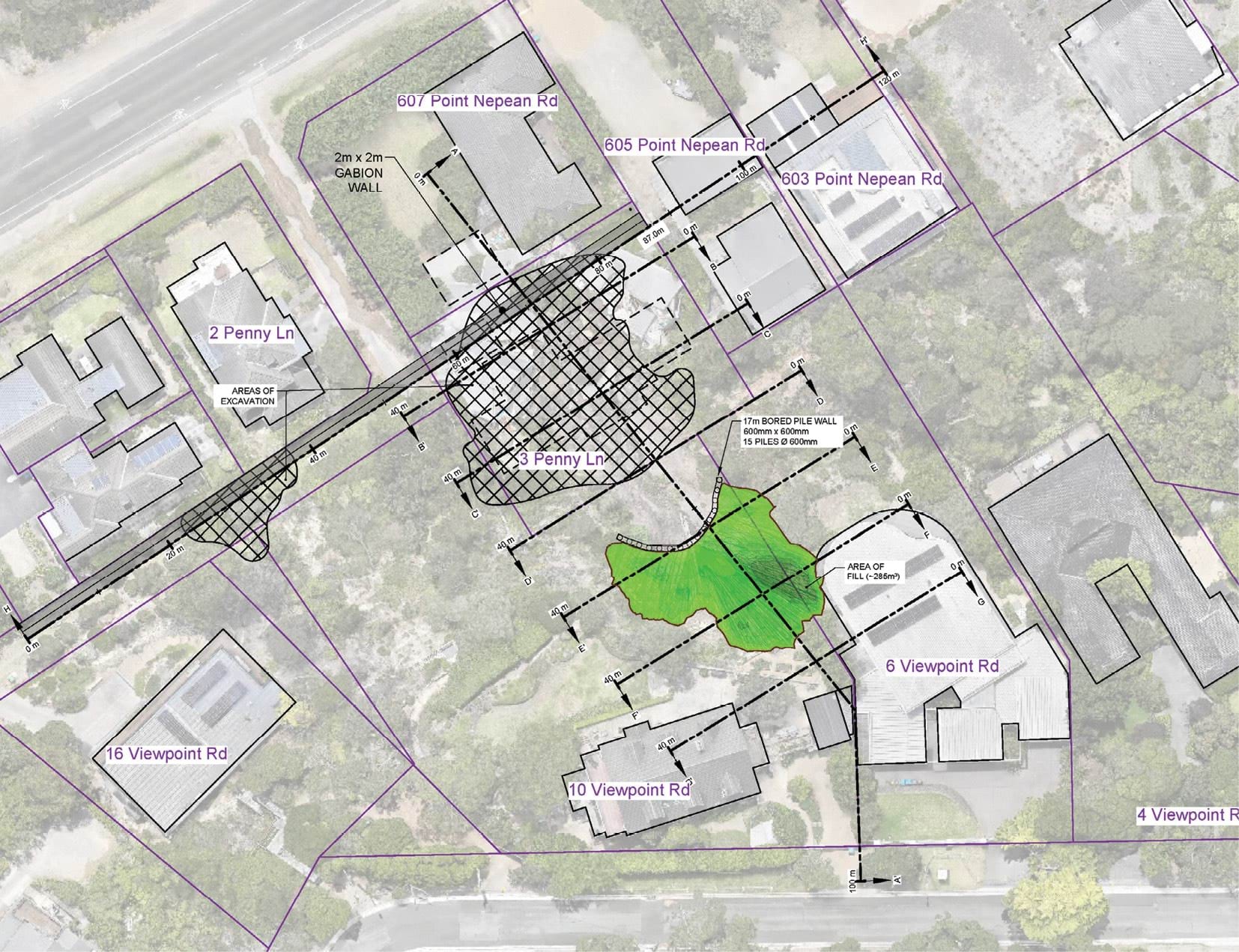
- Mr Paul’s design concept is shown below:
FIGURE 5.2: WSP REMEDIATION DESIGN SHOWING ROCKFILL, PILED GROUND BEAM, AND GABION WALL.23
FIGURE 5.2

- This design concept includes several key features.
- With respect to the eastern gully (the location of the 2025 landslides), Mr Paul proposes:
- The use of engineered rockfill to in-fill the depleted parts of the slope to create a rockfill buttress. This appears in light green in the design image. The rockfill buttress would be comprised of angular, interlocking, high strength crushed quarried rock through which water can permeate.24 The rockfill could be reinforced using geogrid,25 a geosynthetic material used to reinforce soils and other granular materials. Mr Paul suggested the use of Dromana granite to match the appearance of the underlying natural rock.26 He said that, over time, vegetation would grow over the rockfill,27 and that, subject to appropriate engineering and design, provision could be made for the planting of trees.28 The engineered rockfill is intended to be installed from the bottom upwards until the light green area identified in the design image is covered.
- The installation of a piled ground beam at the base of the engineered rockfill.29 This is depicted at the base of the light green area in the design image. The piled ground beam is effectively a short retaining wall, of around 600 millimetres in height, that would be installed at the base of the rockfill to restrain the mass and prevent it from sliding down the slope.30
- As to the western gully (the location of the 2022 landslides), we understand that Mr Paul does not consider that any engineering work is presently necessary in respect of the hillside itself, because the area is returning to a more heavily vegetated state. Vegetation is a natural mitigation measure.31
- However, the design concept also includes the erection of a gabion wall in Penny Lane, which is intended to be a mitigation measure in respect of both the western and eastern gullies. As marked on the design image above, the gabion wall, a wall comprising cages or baskets made from steel wire and filled with stones rocks,32 would run across the southern edge of Penny Lane parallel to Point Nepean Road.33 The purpose of the gabion wall is to act as a barrier to absorb the impact of any further landslide that might occur.34
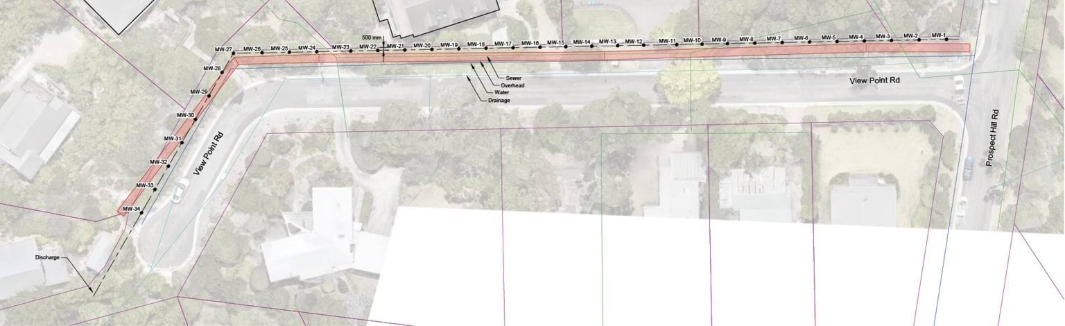
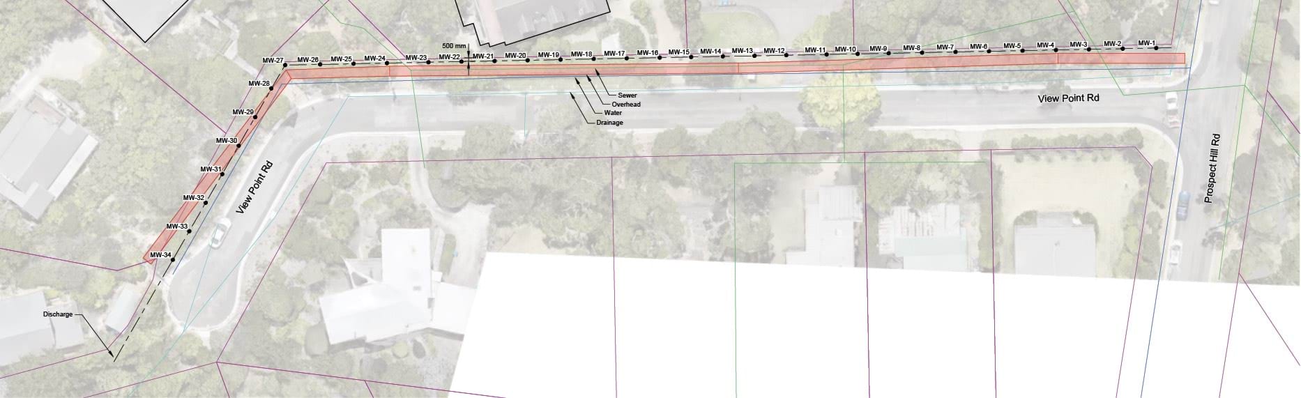
- As for View Point Road, Mr Paul’s concept provides for the installation of 34 groundwater wells down the length of the road.35 The wells would allow for the monitoring of groundwater levels behind the slope, and provide access to dewater the slope (by the insertion of pumps) in the event that groundwater levels were elevated.36
- The groundwater wells are numbered MW-1 to MW-34 in Mr Paul’s image below:
FIGURE 5.3: WSP GROUNDWATER EXTRACTION MONITORING WELLS.37
FIGURE 5.3
- As shown, the groundwater wells run from the intersection of Prospect Hill Road and View Point Road down the length of View Point Road on the northern side. The design does not provide for permanent pumps, but it does incorporate water monitoring devices and, therefore, power to the area would be required.38
Cost and timing
- As to the cost of Mr Paul’s design, Tim Whelan, Director of Major Projects and Engineering at Whelans Group, a firm specialising in the construction of civil infrastructure, was asked to estimate the overall construction cost, assuming full implementation of the design.
- Mr Whelan provided an estimate of $11.5 million exclusive of GST.39 This includes direct costs of approximately $745,000 for the construction of the gabion wall and direct costs of $1.2 million for the installation of the rockfill and construction of the associated pile wall.40
- Mr Paul has estimated the cost of the installation of the 34 groundwater wells down View Point Road to be $200,000 exclusive of GST.41
- These costings are necessarily indicative, only given the design is at a concept stage. Mr Paul considered it possible that the total cost would be less.42
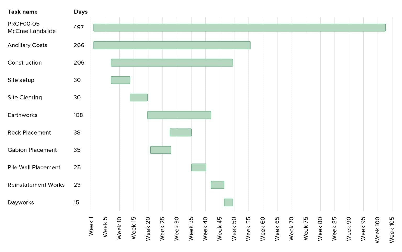
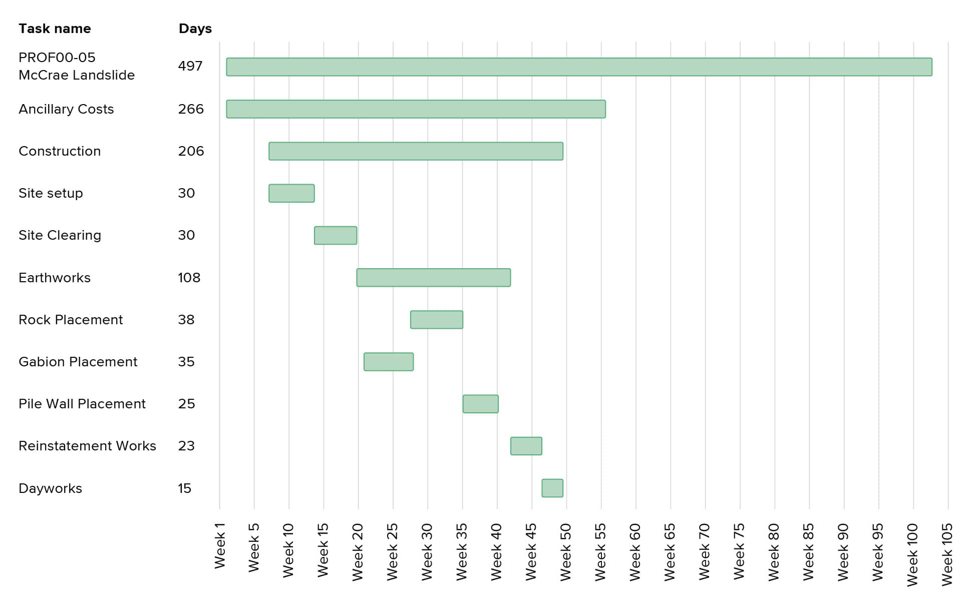
- Mr Whelan also, helpfully, provided a construction program for the works, estimating the approximate time for each stage of construction.43 The estimated timeline is as follows:
- Removal of debris at 3 Penny Lane and two trees at 607–609 Point Nepean Road to allow access to the site – 30 days.44
- Once the site is accessible, construction of the gabion wall at the toe of the escarpment along Penny Lane – 25 days.45
- During the construction of the gabion wall, earthworks would begin in the area of the McCrae Landslide, to remove debris and to build a temporary access road. The access road would allow both the debris further uphill to be removed and enable the rockfill and geofabric separator to be installed. The piled wall and ground beam at the toe would also be constructed. This part of the project is estimated to take 108 days.46
- Works to remove left over debris and equipment, and the placement of hydromulch over the rockfill to allow for landscaping and revegetation – 23 days.47
- Mr Paul explained in his oral evidence to the Board of Inquiry that the overall construction schedule put together by Whelans “nominated a nine-month construction period”, but that, once procurement and the time to design were factored in, an additional three months would be added to the overall timeframe of the project.48 The effect of his evidence was that the works would take about 12 months from procurement.
Landslide Report Infographics
- After the hearing, Mr Paul, thoughtfully, wrote to the Board of Inquiry to explain that he considered that affected residents would be able to return to their homes before the completion of all works.49 His view is that:
- Based on the proposed program, the gabion wall would be completed about 21 weeks (four to five months) after the commencement of the project, and that once the gabion wall is in place, the houses at the toe of the slope could be re-occupied while the remaining works are undertaken.
- The houses at the top of the slope, 6 and 10 –12 View Point Road, could be re-occupied about seven weeks later once the rockfill has been installed.
- Mr Paul’s view in relation to the two houses at the top of the slope is now relevant only to 6 View Point Road as the Shire’s MBS has since removed the Emergency Order which restricted occupation of 10 –12 View Point Road.50 Mr and Mrs Borghesi have now returned to their home.
- Mr Paul also noted in his correspondence to the Board of Inquiry that the program proposed by Mr Whelan commenced with the removal of debris from 3 Penny Lane and Penny Lane more generally. Mr Paul stated that this work could commence earlier, pursuant to a separate contract, while design documentation is finalised for the works on the east and west gullies.51
- Such an approach would enable residents to return home sooner.
Mr Pope’s proposal
The design concept
- Turning now to Mr Pope’s proposed design, a key feature of his proposal is maintaining the west and east gullies in their post-landslide state, being a state that he considers to be more consistent with their landform pre-subdivision.52
- Mr Pope’s design for the west gully is, in substance, unchanged from his prior proposal examined by the Board of Inquiry in the first hearing block. That proposal, being the use of soil nails with netting, was prepared by Mr Pope following the 2022 landslides in the context of negotiations between the Shire and Mr and Mrs Borghesi about works required in response to those landslides.53
- Mr Pope also now proposes the use of soil nails and netting for the east gully. He proposes either a micro piled wall and capping beam (referred to as option 1),54 or a wall made of soil nails and shotcrete (referred to as option 2),55 at the boundary of 6 and 10–12 View Point Road. Mr Pope prefers option 2 because he considers that it is likely to be more constructable, less costly, safer to build, and that there are at least two contractors in the market available to undertake the work.56
- With respect to drainage at the site, Mr Pope’s concept provides for the installation of horizontal drains in the colluvium, in a bid to control groundwater and pore pressure.57
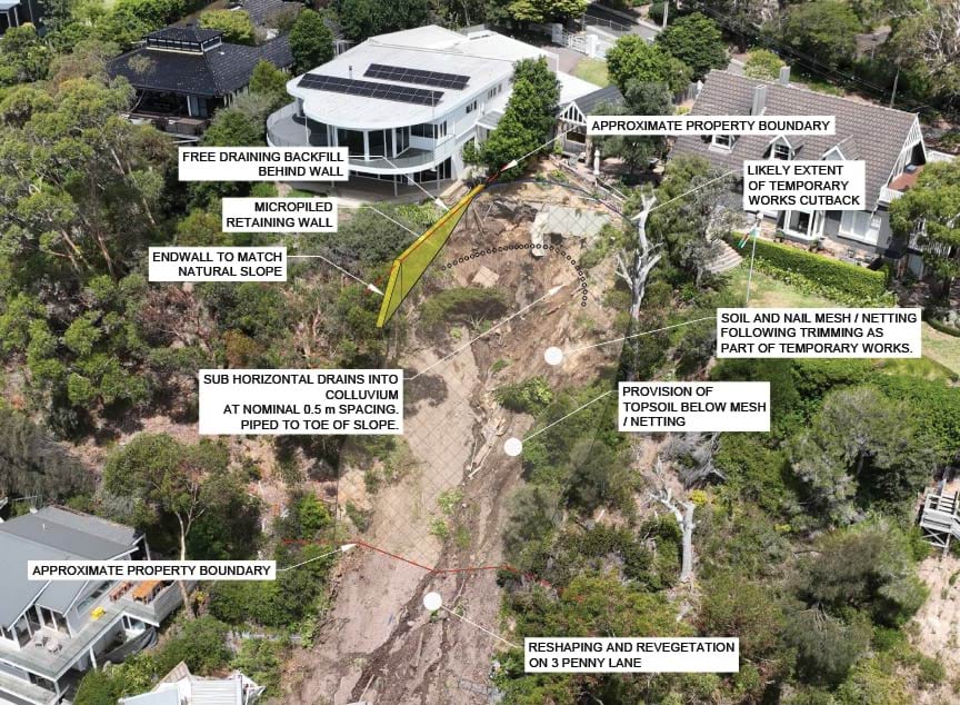
- Mr Pope’s design concepts are shown below. The image on the left side incorporates option 1 at the boundary of 6 and 10–12 View Point Road and the image to the right incorporates option 2 at the boundary.
FIGURE 5.4: COMPARE OF OPTION 1 AND OPTION 2 FOR THE EAST GULLY OF 6 AND 10–12 VIEW POINT ROAD.58
FIGURE 5.4
FIGURE 5.4

- More will be said about the features of Mr Pope’s preferred design concept shortly. It is important to first set out matters that informed his design and the preparatory works required before the soil nails, netting and the boundary wall can be installed.
- As to the matters that informed the design, Mr Pope had regard to development objectives that he considered typically apply to hillside work at residential properties, including the design objectives of the Shire and a design life of 50 years.59 It is important to note that he did not have regard to the design objectives of the land owners on whose land the works are to be undertaken.
- The design was also informed by a number of assumptions, specifically that:
- the design ought to allow for the construction of a new dwelling at 3 Penny Lane;
- the landform pre the McCrae Landslide was not to be reinstated;
- at a minimum, the design had to result in a Factor of Safety rating of 1.5;
- the design would be consistent with the most onerous of the Australian Standards and good first principles of engineering; and
- the works were to be owned and maintained by the property owners.60
- As to the preparatory works required before the soil nails and netting and the boundary wall can be installed, Mr Pope has identified three stages of works.61 Those stages are as follows:
- Landslide head initial works: this involves works at the top of the escarpment to remove materials which may become hazardous, such as parts of the existing retaining wall and plantar boxes located directly above the site of the McCrae Landslide. It also involves work to flatten and trim the headscarp to achieve a target angle of 35 degrees. Mr Pope explains that the rainwater tank at 6 View Point Road may need to be removed as part of the flattening of the area.62 The Board of Inquiry understands that the owners are exploring the removal of those tanks in any event, due to recent deterioration.
- Slope toe works: this involves demolition of the building debris on 3 Penny Lane and repair work at 607–609 Point Nepean Road.
- Mid-slope works: this last stage involves the removal of loose debris deposited down slope from the McCrae Landslide.63
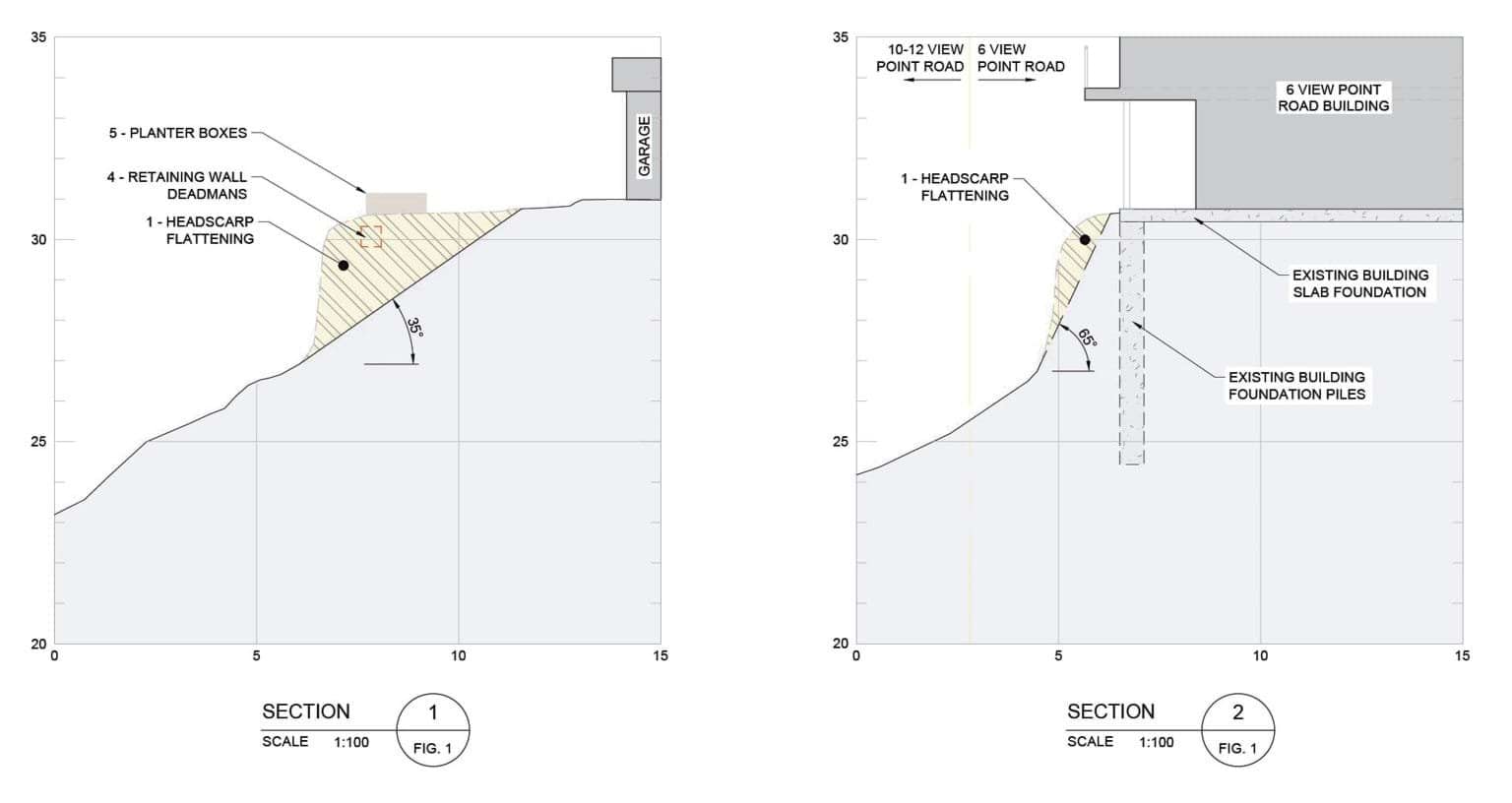
- The second and third stages are self-explanatory. The first stage, the flattening of the headscarp, is best visualised in the following section drawings:
FIGURE 5.5: PSM LANDSLIDE INITIAL WORKS SECTION DRAWINGS.64
FIGURE 5.5
- As can be seen, the east gully is to be flattened, to the extent possible, to reduce the slope angle to 35 degrees. Mr Pope considers that the eastern edge of the east gully cannot be flattened to the same extent, as doing so would undermine the house foundations at 6 View Point Road.65 He proposes flattening that area to 65 degrees. The result of these flattening works would be to reduce the size of the level garden areas at both 6 and 10–12 View Point Road. It would also require the installation of a handrail along the boundary of 6 View Point Road to account for the steep slope along the top of the shotcrete retaining wall.66
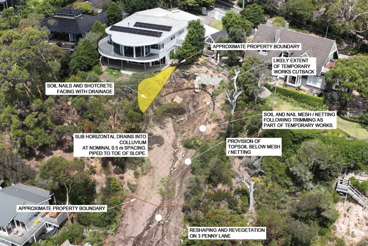
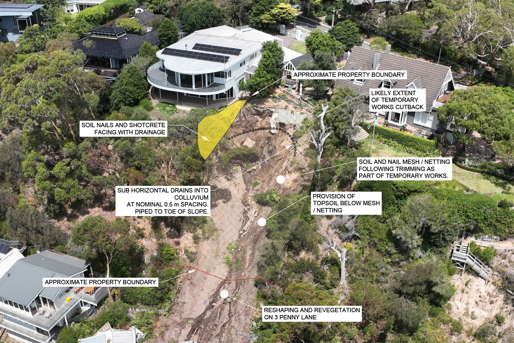
- To assist the discussion that now follows about the features of design concept option 2, the image of the design is shown again below.
FIGURE 5.6: PSM DESIGN OPTION 2 FOR THE EAST GULLY OF 10–12 VIEW POINT ROAD.67
FIGURE 5.6

- The image shows the three distinct proposed engineered structures discussed earlier:
- The yellow area in the image represents the wall constructed of soil nails and shotcrete at the boundary of 6 and 10–12 View Point Road. Mr Pope explained that the soil nails would be nominally spaced every 1.5 square metres and they would be six metres long. The shotcrete is proposed to be 150 millimetres thick. This design does not permit trees to be planted near the wall, as they may adversely affect the structure.68
- The crescent of small black circles in the image represents the horizontal drains proposed to be installed along the base of the colluvium, 0.5 metres apart. The drains are to assist in draining water that travels to the east gully through the shallow aquifer. They are to be piped to the base of the slope to direct the water into a legal point of discharge.69
- The hatching in the image represents the stainless steel mesh held in place with fiberglass soil nails.70 This is to be placed across the face of the east gully, with soil nails of four to six metres in length spaced every two or three square metres.71 Low shrubs and other vegetation, though not trees, could be grown over the area.72
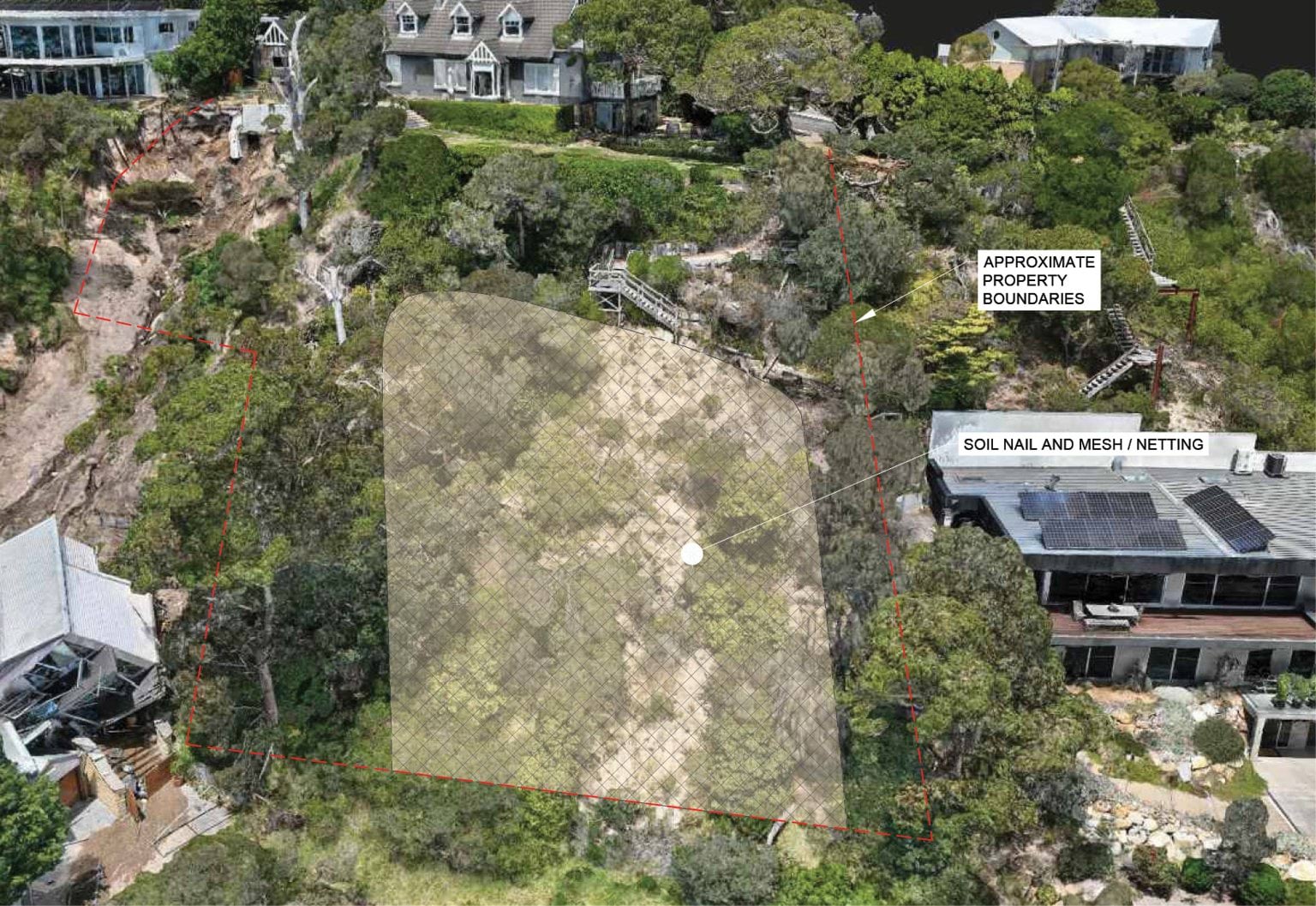
- The same type of concept is proposed for the west gully. It is shown below.
FIGURE 5.7: OBLIQUE VIEW OF SOIL NET DESIGN FOR WEST GULLY OF 10–12 VIEW POINT ROAD.73
FIGURE 5.7
- The effect of Mr Pope’s concept is that a large part of the escarpment at 10–12 View Point Road would be covered with stainless steel mesh.
- It reflects a design approach commonly adopted for public road embankments.74
- A photograph of the soil nails and mesh design used on the Hamilton Highway is produced below:
FIGURE 5.8: COMPLETED SLOPE MITIGATION WORKS ALONG THE HAMILTON HIGHWAY USING SOIL NAILS AND MESH.75
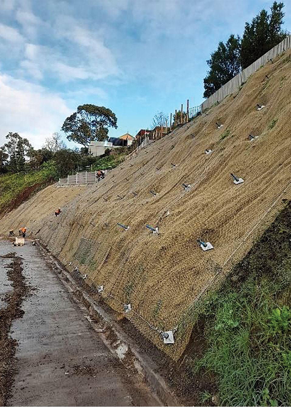
- This design approach requires ongoing maintenance. It would be necessary to clear materials that have built up behind the mesh about every five years, in addition to cleaning the slope drains.76 Any trees that start to grow would also need to be removed.77
Cost and timing
- While Mr Pope’s design will involve ongoing costs associated with the required maintenance, it is likely to be much less costly at the outset than Mr Paul’s proposal.
- Mr Pope’s concept has not been costed by a contractor. However, he gave an estimate of the total cost of the stainless-steel mesh and soil nails to be installed across the west and east gullies. His estimate was based on a rate of $1,300 per square metre,78 with a total area of approximately 1,000 square meters to be covered.79 He estimated a total cost of $1.3 million.80
- The installation of the stainless-steel mesh and soil nails is, of course, only one part of the project. There are also the costs of the three stages of preparatory work, the installation of the wall at the boundary and the installation of the horizontal drains.81
- The overall cost of Mr Pope’s concept will likely be considerably more than $1.3 million.
- As to the installation process, Mr Pope proposes that the works initially be undertaken by small-scale excavation using hand tools, with access to the slope obtained via abseiling.82 He recommended that the slope be monitored during the works,83 by, for example, a grid of tilt sensors.84
- Unlike Mr Paul’s proposal, the work is to be undertaken, at least initially, from the top of the slope downward. Mr Pope considered that method to be safer.85 Mr Paul considers that working from the base of the slope to the top can be performed with safety measures in place.86
Both designs adequately mitigate risk at the site of the landslides
- Having described both Mr Paul and Mr Pope’s concept designs, the next and most important matter to address is whether those concepts would adequately mitigate the risks in relation to further landslides at the site of the 2022 and 2025 landslide events.
Given the evidence of Mr Paul and Mr Pope, this matter can be dealt with very briefly. Their evidence was that both designs would adequately do so.87
Finding
The concept designs provided by geotechnical engineering experts, Darren Paul and Dane Pope, would adequately mitigate the risks in relation to further landslides at the site of the 2022 and 2025 events.
- Mr Paul explained that there are many considerations relevant to the selection of an appropriate concept.88 Both experts agreed that there is no one single correct answer as to what mitigation works should be undertaken.89
- Advice will also need to be sought as to whether any additional mitigation works are required on other parts of the escarpment at 6 and 10–12 View Point Road because Mr Paul and Mr Pope have focussed only on the locations of the 2022 and 2025 landslides.
- The ultimate selection of the concept is a matter to be resolved between the affected residents and those who are to be responsible for the cost of the works. The concept will, of course, require the consent of each affected landowner.90 Aesthetics, cost, future maintenance and timing are all matters that will need to be considered.
- The owners of 6 and 10–12 View Point Road have made it clear to the Board of Inquiry that they strongly prefer Mr Paul’s concept design over Mr Pope’s suggested mesh design.
- Following a public hearing at which the two concepts were examined, a written submission was made on behalf of the owner of 6 View Point Road. The submission explained that Mr Paul’s concept was preferred because it was a permanent, self-sustained remedy, that, once implemented, would require minimal to no future maintenance by the Shire or any other party. The submission also expressed concern that Mr Pope’s proposal of removing soil from the headscarp may undermine the foundations of the house.91
- Mr and Mrs Borghesi, the owners of 10–12 View Point Road, made a submission in which they:
- rejected Mr Pope’s design for the west gully;
- considered the escarpment should be returned as close as possible to its pre-landslide condition;
- supported Mr Paul’s proposal for the east gully, if trees which were present on the boundary between his property and 6 View Point Road are restored; and
- supported the construction of a gabion wall as proposed by Mr Paul.92
- While the selection of a design concept is ultimately a matter for others, some brief observations are made below about the competing concepts.
- First, while Mr Pope’s mesh and soil nail design is more cost effective, it is not in keeping with the surrounding area. The design will restrict the growth of trees and larger plants in an area surrounded by coastal vegetation. 93 Mr Paul’s design uses natural products and allows for the regrowth of vegetation.94
- Second, the use of soil nails could restrict the future use of properties around the escarpment, as future building works could require footings that intersect with the soil nails.95
- Third, Mr Pope’s design requires ongoing maintenance, entailing inspection of the nails and meshing, and tensioning, within two to five years of installation, in addition to further inspections every five years and the flushing of drains.96 Vegetation will also need to be maintained and trimmed where required.97 An agreement will need to be reached as to who will bear responsibility for the ongoing maintenance and associated costs.98
- Fourth, Mr Paul’s concept can be implemented from the bottom of the escarpment (with appropriate safety measures in place), reducing disruption to the owners of 6 and 10–12 View Point Road.99
- Fifth, while Mr Pope’s concept is aimed at restraining the slope, Mr Paul’s concept is aimed at reducing the risk of further landslides and preventing damage to houses at the toe of the escarpment. The gabion wall is to protect the houses at the toe of the slope. It would require the use of space within Penny Lane and may have visual impacts, particularly at the ground level. However, the structure is straightforward to construct and would involve only minimal ongoing maintenance.100 One complication is that the consent of the owners of 3 Penny Lane will be required if the wall is to be built into their boundary.
- Lastly, there are the different approaches to water management. Both proposals - horizontal drains in the east gully (Mr Pope) and groundwater wells along View Point Road (Mr Paul) – would require ongoing maintenance. Both proposals raise questions as to who would be responsible for the maintenance. SEW submitted to the Board of Inquiry that the primary water likely to be captured by groundwater wells is groundwater,101 which is itself, neither the responsibility of the Shire nor SEW.102
In light of the causation findings set out in Chapter 4, the complexity of the matters to be resolved in relation to the mitigation and remediation works, the number of parties with an interest in those matters, and the imperative of advancing the works with sufficient urgency to enable the return of displaced residents, the Board of Inquiry has given consideration to the establishment of an appropriate mechanism to facilitate the resolution of these issues. It makes the following recommendation.
Recommendation 1: Appointment of a mediator The Board of Inquiry recommends a Victorian Government Minister appoint an experienced mediator to engage in a structured process with the Shire, SEW, affected landowners and any other necessary parties, with a view to reaching agreement in relation to appropriate landslide mitigation and remediation works at and around the site of the McCrae Landslide. Recommendation 2: Participation in the mediation process The Board of Inquiry recommends the Shire and SEW appoint or engage a suitably experienced individual to lead and oversee their participation in the mediation process (Recommendation 1), with a view to bringing a fresh and pragmatic perspective to the issues.
5.3 Broader mitigation measures in McCrae
- The final matter for consideration concerns specific mitigation measures in McCrae.
- Little further needs to be said, as many of the recommendations set out in Chapter 8 already address this issue.
- Smart water meters are one mitigation measure now, pleasingly, being used in McCrae. By the time of the first hearing block, SEW had committed to replacing analogue meters in the McCrae area with smart (or “digital”) water meters.103 The roll out started in April 2025 and was scheduled to be completed in June 2025.104 The benefit of smart meters is that they enable household water usage to be monitored on a daily basis.105 They also provide an alert when usage is outside of the ordinary range, enabling SEW to make further inquiries to determine whether there is a water leak,106 and allowing for the quicker identification of bursts to mains in some situations.107
- The implementation of smart meters in landslide-prone areas such as McCrae is a prudent and practical measure. To the extent that the rollout in the McCrae area has not yet been completed, it should be completed as a matter of priority.
- Trench stops are another measure that may be useful in the McCrae area. They were raised by Mr Paul for consideration.108
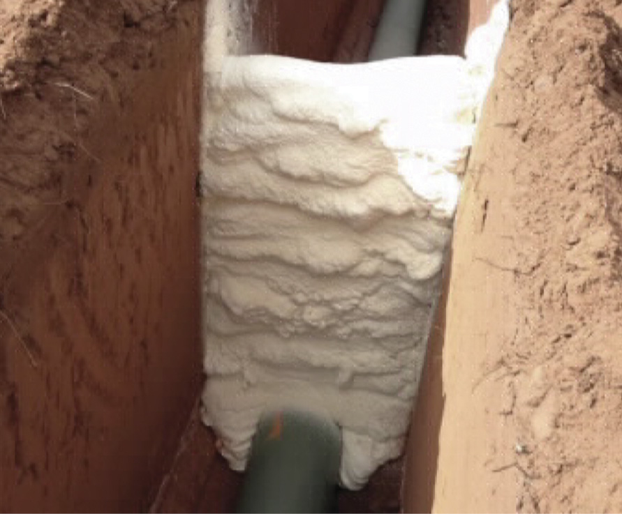
- Trench stops are hydraulicly impervious barriers installed in trenches to prevent them becoming long conduits for water. They operate by creating an impervious barrier that forces water to accumulate in the trench, so that it either migrates through the walls of the trench (more slowly than it would through the bedding material), or it is pushed to the surface, where it is detected or diverted to stormwater via a kerb or stormwater pit.109 Examples of trench stops are shown below.
FIGURE 5.9: EXAMPLES OF TRENCH STOPS.110
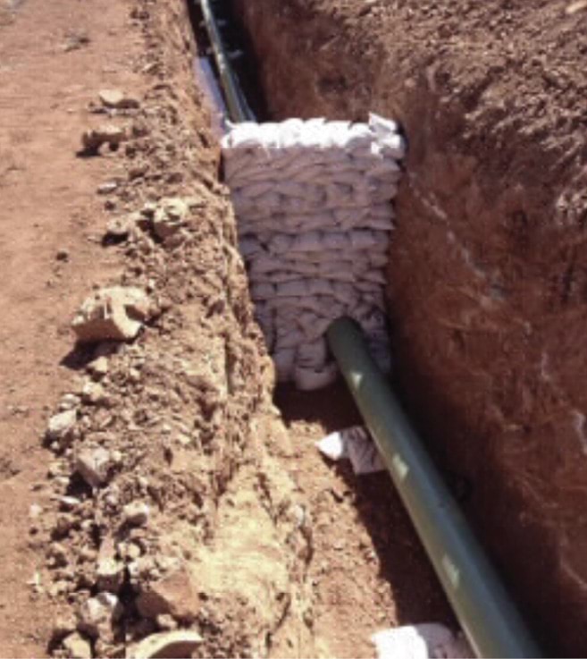
- SEW submitted to the Board of Inquiry that trench stops are unnecessary because “burst water generally flows to the surface in any event”.111 No supporting source was provided. Counsel for SEW questioned Mr Paul about the utility of trench stops. He was asked about the potential for trench stops to be “a nuisance to residents, [as the water diverted to the surface can cause] damage to roads, to gardens, soggy soil”.112 In response, Mr Paul stated:
Groundwater coming to the surface, damage to pavement and wet areas, yeah, that can mean inconvenience, but I’d say not as inconvenient as a landslide.113
- Mr Paul also explained that trench stops can be positioned so that any surface water runs into the stormwater system and not towards an area prone to landslides.114
- Mr Paul also raised for consideration the use of carrier pipes.
Carrier pipes are a sleeve that is placed around the water main such that, in the event of a rupture, water is captured by the carrier pipe and is then diverted through the carrier pipe to a pit.115 They also assist to protect the water main as they make the main more resistant to ground movements which are absorbed by the carrier pipe.116
Recommendation 3: Trench stops and carrier pipes The Board of Inquiry recommends the Shire and SEW obtain expert advice about the use of trench stops and carrier pipes in parts of McCrae to mitigate the risk of landslides, including the use of such measures in more remote locations where water leaks may be less readily detected. - Next, Mr Paul suggested that consideration be given to the replacement of aged vitreous clay sewer pipes and asbestos cement water mains.117
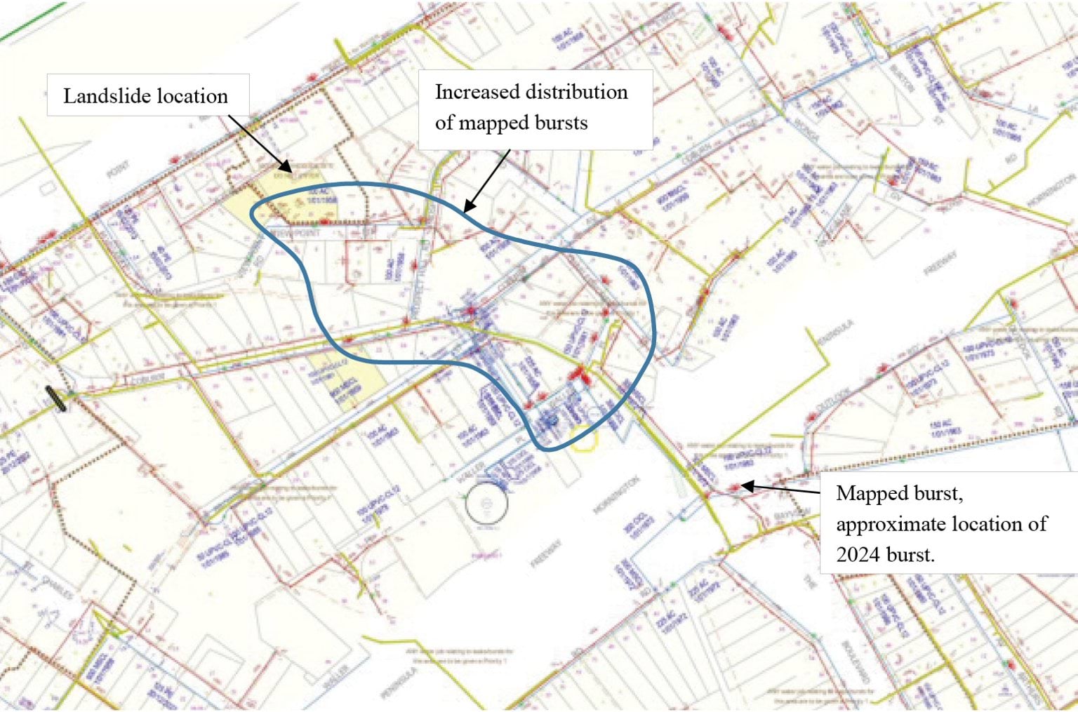
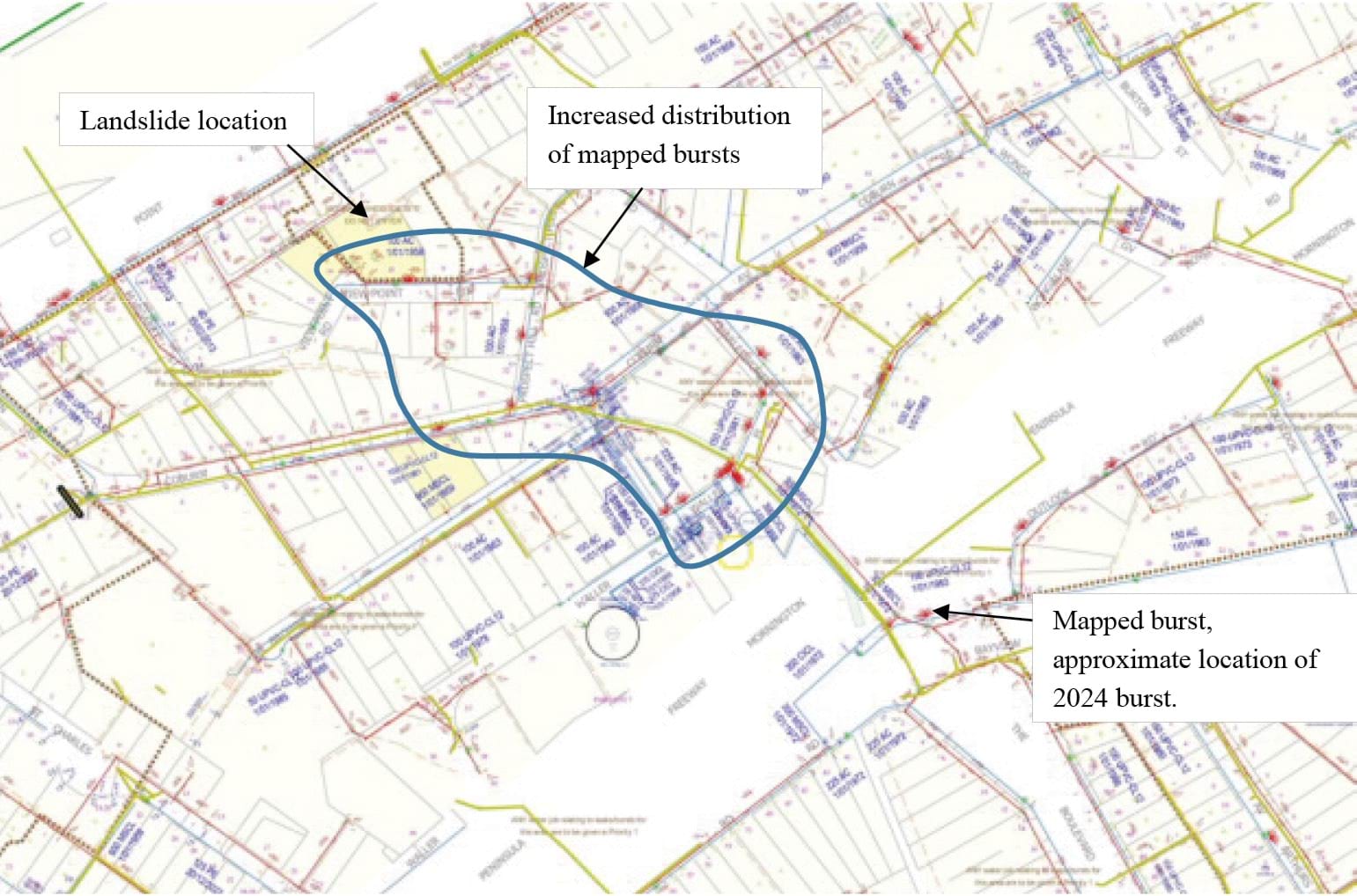
- This map indicates a zone in the McCrae area where there were an anomalous number of failures:
FIGURE 5.10: SOUTH EAST WATER PLAN SHOWING FREQUENCY OF WATER LEAKS WITHIN WATER MAINS IN THE MCCRAE AREA WITH ANNOTATIONS.118
FIGURE 5.10
- Mr Paul considered that the asbestos pipes in the area outlined above were aging, brittle, and prone to cracking,119 and had a higher rate of leakage compared to other areas in McCrae.120
Finally, SEW has informed the Board of Inquiry that the burst water main that has been found by the Board of Inquiry to have caused the 5 January 2025 landslide and McCrae Landslide may have contained a manufacturing defect.121 SEW is presently examining whether this issue may affect other pipes in the area.122 Such investigations should proceed without delay.
Recommendation 4: Assessment of infrastructure The Board of Inquiry recommends the Shire and SEW thoroughly assess their water infrastructure in McCrae to identify any need for repair or replacement works to mitigate landslide risk. SEW should also adopt this measure in relation to its sewer system.
Chapter 5 Endnotes
- 1 Exhibit CA-87, McCrae Landslide Remediation and Mitigation Report prepared by WSP, 12 August 2025, [DPA.0005.0001.0001 at _0007].
- 2 Exhibit CA-67, McCrae Landslide Causation Report prepared by WSP, 21 July 2025, [DPA.0004.0001.0001 at _0016].
- 3 Exhibit CA-86, McCrae Landslide Mitigation Report prepared by PSM, 11 August 2025, [MSC.5088.0001.0007 at .0025–.0031]; Exhibit CA-87, McCrae Landslide Remediation and Mitigation Report prepared by WSP, 12 August 2025, [DPA.0005.0001.0001 at _0009, _0012].
- 4 Public Hearing Transcript, Darren Paul and Dane Pope, 18 August 2025, 1357–1358.
- 5 Public Hearing Transcript, Darren Paul and Dane Pope, 18 August 2025, 1355–1356.
- 6 Public Hearing Transcript, Darren Paul, 18 August 2025, 1357.
- 7 Public Hearing Transcript, Darren Paul, 18 August 2025, 1389.
- 8 Public Hearing Transcript, Darren Paul, 18 August 2025, 1390–1391.
- 9 Public Hearing Transcript, Darren Paul and Dane Pope, 18 August 2025, 1408.
- 10 Public Hearing Transcript, Dane Pope, 18 August 2025, 1358.
- 11 Public Hearing Transcript, Dane Pope, 18 August 2025, 1393.
- 12 Public Hearing Transcript, Dane Pope, 18 August 2025, 1373.
- 13 Exhibit CA-67, McCrae Landslide Causation Report prepared by WSP, 21 July 2025, [DPA.0004.0001.0001 at _0114].
- 14 Exhibit CA-67, McCrae Landslide Causation Report prepared by WSP, 21 July 2025, [DPA.0004.0001.0001 at _0114–_0116].
- 15 Exhibit CA-67, McCrae Landslide Causation Report prepared by WSP, 21 July 2025, [DPA.0004.0001.0001 at _0116].
- 16 Exhibit CA-67, McCrae Landslide Causation Report prepared by WSP, 21 July 2025, [DPA.0004.0001.0001 at _0117–_0118].
- 17 Exhibit CA-67, McCrae Landslide Causation Report prepared by WSP, 21 July 2025, [DPA.0004.0001.0001 at _0118–_0119].
- 18 Exhibit CA-67, McCrae Landslide Causation Report prepared by WSP, 21 July 2025, [DPA.0004.0001.0001 at _0119–_0120].
- 19 Exhibit CA-67, McCrae Landslide Causation Report prepared by WSP, 21 July 2025, [DPA.0004.0001.0001 at _0120–_0121].
- 20 Exhibit CA-67, McCrae Landslide Causation Report prepared by WSP, 21 July 2025, [DPA.0004.0001.0001 at _0120–_0121].
- 21 Exhibit CA-87, McCrae Landslide Remediation and Mitigation Report prepared by WSP, 12 August 2025, [DPA.0005.0001.0001 at _0008].
- 22 Exhibit CA-87, McCrae Landslide Remediation and Mitigation Report prepared by WSP, 12 August 2025, [DPA.0005.0001.0001 at _0008].
- 23 Exhibit CA-87, McCrae Landslide Remediation and Mitigation Report prepared by WSP, 12 August 2025, [DPA.0005.0001.0001 at _0019].
- 24 Exhibit CA-87, McCrae Landslide Remediation and Mitigation Report prepared by WSP, 12 August 2025, [DPA.0005.0001.0001 at _0009–_0010].
- 25 Exhibit CA-87, McCrae Landslide Remediation and Mitigation Report prepared by WSP, 12 August 2025, [DPA.0005.0001.0001 at _0010].
- 26 Exhibit CA-87, McCrae Landslide Remediation and Mitigation Report prepared by WSP, 12 August 2025, [DPA.0005.0001.0001 at _0009–_0010].
- 27 Exhibit CA-67, McCrae Landslide Causation Report prepared by WSP, 21 July 2025, [DPA.0004.0001.0001 at _0114–_0116].
- 28 Public Hearing Transcript, Darren Paul, 18 August 2025, 1365.
- 29 Exhibit CA-87, McCrae Landslide Remediation and Mitigation Report prepared by WSP, 12 August 2025, [DPA.0005.0001.0001 at _0009].
- 30 Exhibit CA-87, McCrae Landslide Remediation and Mitigation Report prepared by WSP, 12 August 2025, [DPA.0005.0001.0001 at _0009].
- 31 Public Hearing Transcript, Darren Paul, 18 August 2025, 1361.
- 32 Public Hearing Transcript, Darren Paul, 18 August 2025, 1361.
- 33 Exhibit CA-87, McCrae Landslide Remediation and Mitigation Report prepared by WSP, 12 August 2025, [DPA.0005.0001.0001 at _0011]; Public Hearing Transcript, Darren Paul, 18 August 2025, 1361.
- 34 Exhibit CA-87, McCrae Landslide Remediation and Mitigation Report prepared by WSP, 12 August 2025, [DPA.0005.0001.0001 at _0011].
- 35 Exhibit CA-87, McCrae Landslide Remediation and Mitigation Report prepared by WSP, 12 August 2025, [DPA.0005.0001.0001 at _0010 –_0011, _0023].
- 36 Exhibit CA-87, McCrae Landslide Remediation and Mitigation Report prepared by WSP, 12 August 2025, [DPA.0005.0001.0001 at _0010].
- 37 Exhibit CA-87, McCrae Landslide Remediation and Mitigation Report prepared by WSP, 12 August 2025, [DPA.0005.0001.0001 at _0023].
- 38 Public Hearing Transcript, Darren Paul, 18 August 2025, 1362–1363.
- 39 Exhibit CA-87, McCrae Landslide Remediation and Mitigation Report prepared by WSP, 12 August 2025, [DPA.0005.0001.0001 at _0013].
- 40 Exhibit CA-87, McCrae Landslide Remediation and Mitigation Report prepared by WSP, 12 August 2025, [DPA.0005.0001.0001 at _0013, _0029].
- 41 Exhibit CA-87, McCrae Landslide Remediation and Mitigation Report prepared by WSP, 12 August 2025, [DPA.0005.0001.0001 at _0013].
- 42 Public Hearing Transcript, Darren Paul, 18 August 2025, 1384.
- 43 Exhibit CA-87, McCrae Landslide Remediation and Mitigation Report prepared by WSP, 12 August 2025, [DPA.0005.0001.0001 at _0026].
- 44 Exhibit CA-87, McCrae Landslide Remediation and Mitigation Report prepared by WSP, 12 August 2025, [DPA.0005.0001.0001 at _0012, _0026, _0031].
- 45 Exhibit CA-87, McCrae Landslide Remediation and Mitigation Report prepared by WSP, 12 August 2025, [DPA.0005.0001.0001 at _0012, _0027, _0031].
- 46 Exhibit CA-87, McCrae Landslide Remediation and Mitigation Report prepared by WSP, 12 August 2025, [DPA.0005.0001.0001 at _0012, _0026 –_0027, _0031].
- 47 Exhibit CA-87, McCrae Landslide Remediation and Mitigation Report prepared by WSP, 12 August 2025, [DPA.0005.0001.0001 at _0012, _0027, _0031].
- 48 Public Hearing Transcript, Darren Paul, 18 August 2025, 1383.
- 49 Email from Darren Paul to Solicitors Assisting the Board of Inquiry about construction schedule, 18 August 2025, [DPA.0008.0001.0001].
- 50 Email from Mornington Peninsula Shire Council’s solicitors to Solicitors Assisting the Board of Inquiry about reoccupation of 10–12 View Point Road, 12 August 2025, [INQ.0015.0001.0001].
- 51 Email from Darren Paul to Solicitors Assisting the Board of Inquiry about construction schedule, 18 August 2025, [DPA.0008.0001.0001].
- 52 Public Hearing Transcript, Dane Pope, 18 August 2025, 1393.
- 53 Public Hearing Transcript, Dane Pope, 4 May 2025, 148–149, 151–153; Public Hearing Transcript, Dane Pope, 18 August 2025, 1368.
- 54 Exhibit CA-86, McCrae Landslide Mitigation Report prepared by PSM, 11 August 2025, [MSC.5088.0001.0007 at .0052–.0053].
- 55 Exhibit CA-86, McCrae Landslide Mitigation Report prepared by PSM, 11 August 2025, [MSC.5088.0001.0007 at .0054].
- 56 Exhibit CA-86, McCrae Landslide Mitigation Report prepared by PSM, 11 August 2025, [MSC.5088.0001.0007 at .0054].
- 57 Exhibit CA-86, McCrae Landslide Mitigation Report prepared by PSM, 11 August 2025, [MSC.5088.0001.0007 at .0053–.0054].
- 58 Exhibit CA-86, McCrae Landslide Mitigation Report prepared by PSM, 11 August 2025, [MSC.5088.0001.0007 at .0061–.0063].
- 59 Exhibit CA-86, McCrae Landslide Mitigation Report prepared by PSM, 11 August 2025, [MSC.5088.0001.0007 at .0047].
- 60 Exhibit CA-86, McCrae Landslide Mitigation Report prepared by PSM, 11 August 2025, [MSC.5088.0001.0007 at .0048].
- 61 Exhibit CA-86, McCrae Landslide Mitigation Report prepared by PSM, 11 August 2025, [MSC.5088.0001.0007 at .0034–.0035, .0037–.0038]. Note that, while not expressly referred to, the Board of Inquiry understands the mitigation works to be stage 4 of PSM’s temporary works advice.
- 62 Exhibit CA-86, McCrae Landslide Mitigation Report prepared by PSM, 11 August 2025, [MSC.5088.0001.0007 at .0035].
- 63 Exhibit CA-86, McCrae Landslide Mitigation Report prepared by PSM, 11 August 2025, [MSC.5088.0001.0007 at .0034–.0035].
- 64 Exhibit CA-86, McCrae Landslide Mitigation Report prepared by PSM, 11 August 2025, [MSC.5088.0001.0007 at .0041].
- 65 Exhibit CA-86, McCrae Landslide Mitigation Report prepared by PSM, 11 August 2025, [MSC.5088.0001.0007 at .0034].
- 66 Exhibit CA-90, Joint Report on remediation and mitigation prepared by expert conclave, 14 August 2025, [INQ.0012.0001.0001 at _0002].
- 67 Exhibit CA-86, McCrae Landslide Mitigation Report prepared by PSM, 11 August 2025, [MSC.5088.0001.0007 at .0063].
- 68 Exhibit CA-86, McCrae Landslide Mitigation Report prepared by PSM, 11 August 2025, [MSC.5088.0001.0007 at .0054].
- 69 Exhibit CA-90, Joint Report on remediation and mitigation prepared by expert conclave, 14 August 2025, [INQ.0012.0001.0001 at _0002].
- 70 Public Hearing Transcript, Dane Pope, 18 August 2025, 1372; Exhibit CA-86, McCrae Landslide Mitigation Report prepared by PSM, 11 August 2025, [MSC.5088.0001.0007 at .0053]; Exhibit CA-90, Joint Report on remediation and mitigation prepared by expert conclave, 14 August 2025, [INQ.0012.0001.0001].
- 71 Exhibit CA-86, McCrae Landslide Mitigation Report prepared by PSM, 11 August 2025, [MSC.5088.0001.0007 at .0053].
- 72 Public Hearing Transcript, Dane Pope, 18 August 2025, 1372; Exhibit CA-86, McCrae Landslide Mitigation Report prepared by PSM, 11 August 2025, [MSC.5088.0001.0007 at .0054].
- 73 Exhibit CA-86, McCrae Landslide Mitigation Report prepared by PSM, 11 August 2025, [MSC.5088.0001.0007 at .0059].
- 74 Public Hearing Transcript, Dane Pope, 8 May 2025, 151.
- 75 Exhibit CA-86, McCrae Landslide Mitigation Report prepared by PSM, 11 August 2025, [MSC.5088.0001.0007 at .0066].
- 76 Exhibit CA-90, Joint Report on remediation and mitigation prepared by expert conclave, 14 August 2025, [INQ.0012.0001.0001 at _0002].
- 77 Exhibit CA-90, Joint Report on remediation and mitigation prepared by expert conclave, 14 August 2025, [INQ.0012.0001.0001 at _0002].
- 78 Public Hearing Transcript, Dane Pope, 18 August 2025, 1385.
- 79 Exhibit CA-90, Joint Report on remediation and mitigation prepared by expert conclave, 14 August 2025, [INQ.0012.0001.0001].
- 80 Public Hearing Transcript, Dane Pope, 18 August 2025, 1385.
- 81 Public Hearing Transcript, Dane Pope, 18 August 2025, 1385.
- 82 Exhibit CA-86, McCrae Landslide Mitigation Report prepared by PSM, 11 August 2025, [MSC.5088.0001.0007 at .0035].
- 83 Exhibit CA-86, McCrae Landslide Mitigation Report prepared by PSM, 11 August 2025, [MSC.5088.0001.0007 at .0036].
- 84 Public Hearing Transcript, Dane Pope, 18 August 2025, 1380.
- 85 Public Hearing Transcript, Dane Pope, 18 August 2025, 1380.
- 86 Public Hearing Transcript, Darren Paul, 18 August 2025, 1380–1381.
- 87 Public Hearing Transcript, Darren Paul and Dane Pope, 18 August 2025, 1377–1378.
- 88 Public Hearing Transcript, Darren Paul, 18 August 2025, 1357.
- 89 Public Hearing Transcript, Darren Paul and Dane Pope, 18 August 2025, 1356–1357.
- 90 Public Hearing Transcript, Darren Paul and Dane Pope, 18 August 2025, 1358.
- 91 Public Submission of McCrae Resident, 19 August 2025, [RES.0011.0002.0001].
- 92 Public Submission of Gerrard and Bronwyn Borghesi, 19 August 2025, [RES.0001.0006.0004 at _0001–_0002].
- 93 Public Hearing Transcript, Dane Pope, 18 August 2025, 1372.
- 94 Public Hearing Transcript, Darren Paul, 18 August 2025, 1365.
- 95 Public Hearing Transcript, Darren Paul, 18 August 2025, 1389.
- 96 Public Hearing Transcript, Dane Pope, 18 August 2025, 1375–1376.
- 97 Public Hearing Transcript, Dane Pope, 18 August 2025, 1376.
- 98 Public Hearing Transcript, Darren Paul, 18 August 2025, 1378.
- 99 Email from Darren Paul to Solicitors Assisting the Board of Inquiry about construction schedule, 18 August 2025, [DPA.0008.0001.0001].
- 100 Public Hearing Transcript, Darren Paul, 18 August 2025, 1366.
- 101 Submission of South East Water about measures to reduce or prevent the risk of another landslide, 22 August 2025, [SEW.0001.0002.4205 at _0007].
- 102 Submission of Mornington Peninsula Shire Council about mitigation of further landslides, 22 August 2025, [MSC.5094.0001.0050 at .0052]; South East Water, Response to first set of potential adverse findings, 21 August 2025, [SEW.0001.0002.4203 at _0009].
- 103 Public Hearing Transcript, Lara Olsen, 16 May 2025, 565.
- 104 Public Hearing Transcript, Lara Olsen, 16 May 2025, 565.
- 105 Public Hearing Transcript, Andrew Forster-Knight, 24 June 2025, 1011.
- 106 Public Hearing Transcript, Lara Olsen, 16 May 2025, 567.
- 107 Public Hearing Transcript, Andrew Forster-Knight, 24 June 2025, 1012.
- 108 Exhibit CA-67, McCrae Landslide Causation Report prepared by WSP, 21 July 2025, [DPA.0004.0001.0001 at _0120]; Public Hearing Transcript, Darren Paul, 18 August 2025, 1366–1367.
- 109 Public Hearing Transcript, Darren Paul, 18 August 2025, 1399.
- 110 Exhibit CA-67, McCrae Landslide Causation Report prepared by WSP, 21 July 2025, [DPA.0004.0001.0001 at _0121].
- 111 Submission of South East Water about measures to reduce or prevent the risk of another landslide, 22 August 2025, [SEW.0001.0002.4205 at _0005].
- 112 Public Hearing Transcript, Darren Paul, 18 August 2025, 1398.
- 113 Public Hearing Transcript, Darren Paul, 18 August 2025, 1399.
- 114 Public Hearing Transcript, Darren Paul, 18 August 2025, 1399–1400.
- 115 Public Hearing Transcript, Darren Paul, 18 August 2025, 1403.
- 116 Public Hearing Transcript, Darren Paul, 18 August 2025, 1403.
- 117 Public Hearing Transcript, Darren Paul, 18 August 2025, 1367.
- 118 Exhibit CA-67, McCrae Landslide Causation Report prepared by WSP, 21 July 2025, [DPA.0004.0001.0001 at _0080].
- 119 Public Hearing Transcript, Darren Paul, 18 August 2025, 1394.
- 120 Exhibit CA-87, McCrae Landslide Remediation and Mitigation Report prepared by WSP, 12 August 2025, [DPA.0005.0001.0001 at _0011].
- 121 Yvonne Wu and John Scheirs, ExcelPlas Expert Report – Condition Monitoring of a PVC Pipe, 13 June 2025, [SEW.0001.0001.5467].
- 122 Exhibit CA-65, Second Witness Statement of Julian Tully, 2 July 2025, 4 –5 [22]–[23].
Updated