

4.1 Introduction
- A central task of the Board of Inquiry has been to inquire into, and report on, what caused the McCrae Landslide. In the course of undertaking that inquiry, however, it became apparent that understanding the cause of the McCrae Landslide required consideration of the causes of the November 2022 landslides and, in particular, the 5 January 2025 landslide, all of which predominantly occurred on the escarpment at 10–12 View Point Road. This Chapter therefore examines and identifies the causes of those landslides in turn.
- Shortly stated, the November 2022 landslides, 5 January 2025 landslide and McCrae Landslide share a common causal factor: water. The experts are unanimous in that opinion.
- What divides the experts is the source of that water. This is addressed in detail below.
- As will become apparent from the analysis that follows, there are complexities in determining the causes of landslides. The question does not typically lend itself to a straightforward answer. Landslides are caused by the interaction of multiple factors – some of which are natural, some of which are anthropogenic (that is, caused by human activity). Complexities reside in disentangling these causal factors and weighing their relative contributions. Notwithstanding these complexities, a simple point emerged from the evidence: excess water in an area susceptible to landslides is inherently dangerous.
4.2 The experts
- The Board of Inquiry was assisted in its task of determining the causes of the landslides by several expert witnesses.
- Expert evidence on the causes of the landslides was principally given by three geotechnical engineers specialising in landslides:
- Darren Paul of WSP, who was engaged by the Board of Inquiry;
- Dane Pope of PSM, who was engaged by the Shire; and
- David Hartley of SMEC, who was engaged by SEW.
- Mr Pope and Mr Paul gave opinions about the causes of the November 2022 landslides. All three experts gave opinions about the causes of the 5 January 2025 landslide and the McCrae Landslide.
- In the course of answering the question of what caused the 5 January 2025 landslide and the McCrae Landslide, it emerged that resolution of that question turned on two subsidiary questions. The first was whether water from another location could travel through the ground to the landslide site. The second was whether the chemical composition of the water emanating from the headscarp could identify its source. In seeking to answer those subsidiary questions, evidence was also provided by the following experts:
- a geochemist/geochemical modeller, Hong Vu of WSP; and
- four hydrogeologists: Stephen Makin of WSP, Hugo Bolton of SMEC, Christopher Jewell of CM Jewell & Associates (engaged by SEW), and Phillip Hitchcock of Australian Environmental Auditors Pty Ltd (engaged by the Shire).
- A list of all of the expert reports received by the Board of Inquiry in relation to the cause of the 5 January 2025 landslide and the McCrae Landslide is contained in Appendix E.
FIGURE 4.1: THE KEY EXPERTS
| Board of Inquiry | SEW | The Shire |
|---|---|---|
| Mr Darren Paul, Technical Director – Engineering Geology of WSP | Mr David Hartley, Senior Associate – Engineer of SMEC | Mr Dane Pope, Principal Geotechnical Engineer of PSM |
| Dr Hong Vu, Senior Associate Geochemist/Geochemical Modeller of WSP | Mr Hugo Bolton, Technical Principal – Hydrogeologist of SMEC | Mr Phillip Hitchcock, Principal Hydrogeologist of Australian Environment Auditors Pty Ltd |
| Mr Stephen Makin, Senior Hydrogeologist of WSP | Mr Christopher Jewell, Principal Hydrogeologist of CM Jewell & Associates |
- An expert conclave was held on questions of causation on 28 and 29 July 2025. It was attended by Mr Paul, Mr Makin (on 28 July 2025 only), Mr Pope, Mr Hitchcock, Mr Hartley and Mr Bolton. On 1 August 2025, a further expert conclave was held specifically concerning geochemistry. It was attended by Mr Paul, Mr Hitchcock, Mr Hartley, Mr Bolton, Dr Vu and Mr Jewell.
- The participants in the conclave concerning causation produced a joint report on 31 July 2025.1 The report included a table which recorded the comments of each of Mr Paul, Mr Pope, Mr Hitchcock and Mr Hartley about the factors that the experts agreed on and the factors in dispute. Similarly, the participants in the geochemistry conclave produced a joint report on 1 August 2025, containing a minute of the conclave.2
- Further details about the expert evidence process can be found in Appendix E.
4.3 Some basics in the causes of landslides, geology and hydrogeology
- It is not possible to understand and analyse the causes of landslides without first understanding some basic principles.
- The most convenient starting point is understanding the factors that contribute to causing landslides.
Factors that contribute to causing landslides
- The factors that contribute to causing landslides can be grouped into two broad categories: (1) preparatory factors; and (2) triggering factors.3
- Preparatory factors make the landscape susceptible or prone to landslides. Identifying and assessing preparatory factors can allow suitably trained professionals to identify where landslides might occur and what might happen if they do occur. An understanding of preparatory factors is key to the development of landslide susceptibility maps and associated planning controls such as an EMO.4
- The preparatory factors addressed in this Report are as follows and warrant brief explanation:
| Erosion of the escarpment | Erosion can change the height and angle of a slope. The steeper and higher a slope, the more susceptible it is to landslides. That is because the forces of gravity acting on steeper slopes are greater.5 |
| Anthropogenic changes | Anthropogenic changes are changes made to the landscape by humans, which can increase landslide susceptibility. Examples of anthropogenic changes include earthworks on a slope, development that obstructs or alters groundwater flow or changes the natural surface water flow paths, and the installation of water bearing services (sewers, water main and stormwater pipes).6 |
| Fill at the top or face of a slope | The placement of fill at the top of a slope or on the face of a slope can increase the stress applied to a slope, rendering it more susceptible to landslides.7 |
| Loss or removal of vegetation | The loss or removal of vegetation can weaken slope stability in several ways: less water is drawn up from the soil, more water is able to infiltrate the ground, and fewer roots remain to bind and reinforce the strength of the soil.8 |
| Piping through soils upslope | Piping refers to subsurface voids and channels within soil that can provide preferential pathways for water. These pathways can convey water to different parts of a slope, weakening the soil and thereby increasing its susceptibility to landslides.9 |
| Groundwater from a shallow aquifer | Water from a shallow aquifer – an underground water-bearing layer close to the surface – can elevate moisture levels, pre-saturate an escarpment, weaken the soil, and increase its susceptibility to landslides.10 |
| Stormwater leakage | Defects in a stormwater system can promote loss of water from the system causing water to infiltrate the ground, reducing its stability and increasing the risk of landslides.11 |
| Water from domestic water usage | Water from domestic usage, such as irrigation systems, can result in increased subsurface water flow and wetting of soils, which, again, can increase the risk of landslides.12 |
- Triggering factors are those that trigger landslides. They determine when a landslide might occur. Amongst other things, landslide risk mitigation might focus on reducing the potential for causal factors to trigger a landslide.13
- The triggering factors addressed in this Report are:
| Earthquake | Rainfall | Leaks from water bearing services |
| Erosion | Groundwater from aquifer | Domestic usage (irrigation) |
- Each of those triggering factors will be considered in greater detail below.
- In the joint causation report, the experts evaluated the relative contribution of each preparatory and triggering factor on a scale from insignificant to significant. They expressed their assessments by reference to a confidence scale ranging from very low to very high. The scales are captured in the following table:14
| Magnitude of Contribution | Level of Certainty | ||
|---|---|---|---|
| Significant | 80% - 100% | Very High | 80% - 100% |
| Major | 30% - <80% | High | 60% - <80% |
| Medium | 10% - <30% | Moderate | 40% - <60% |
| Minor | 1% - <10% | Low | 20% - <40% |
| Insignificant | 0 - <1% | Very Low | 0 - <%20 |
McCrae engineering geological model
- In order to understand the preparatory and triggering factors that may have contributed to causing the 5 January 2025 landslide and the McCrae Landslide, each geotechnical expert developed what is known as an “engineering geological model” for the McCrae escarpment and its surrounds.
- In broad terms, the purpose of the model is twofold: (1) to comprehensively identify the “geological units”, essentially soils and rocks at a site; and (2) to identify and describe how those units interact with one another within the ground.15 Critically, the model assists in answering the first subsidiary question identified above: whether water from another location could travel through the ground to the landslide site.
- The models developed by the geotechnical experts were largely consistent; any differences were at the margins.16 Four geological units were identified and analysed as part of the model for McCrae:
- fill;
- transported soils (colluvium and aeolian soils);
- residual granitic soils; and
- extremely weathered granite.17
- Each geological unit has distinct properties – this has two significant implications. First, those properties determine how permeable that geological unit is to water, which in turn influences the “linear velocity” – the rate at which water can move through that medium.18 Second, the geological unit’s properties also influence the chemical composition of water as it passes through that medium.19 As will be seen, both linear velocity and the changes in the chemical composition of water are important to understanding the causes of the 5 January 2025 landslide and the McCrae Landslide.
- Set out below is a table prepared by Mr Paul which summarises the properties of the four geological units:
FIGURE 4.2: GEOLOGICAL UNITS IDENTIFIED AND INCLUDED IN THE ENGINEERING GEOLOGICAL MODEL.20
| Unit | Description | Occurrence |
|---|---|---|
| Fill | Highly variable, typically silty sand to sand. Multiple generations of fill, in particular near the McCrae escarpment. Backfilling of service trenches. | Observed from surface across the site with variable thickness, typically less than 1.5 metres. Localised deep fill is expected behind retaining walls and within service trench backfill. |
| Transported Soils (Colluvium and Aeolian Soils) | Comprises colluvium (soils deposited through landslide processes) and aeolian (wind blown) sands. Clayey sand to sand with cobbles and gravel. Aeolian sands typically do not contain clays in notable proportions and the aeolian proportions are typically calcareous. | Aeolian sands are largely present at the base of the escarpment. May be observed in thin horizons or be absent at the top of the escarpment. Colluvium is observed as an apron around Arthurs Seat, with areas of increased thickness expected within both existing gullies and historic, now buried, gullies/channels. |
| Residual Granitic Soils | Clayey sand to sandy clay. Clays are typically very stiff to hard and sands are typically dense to very dense. | Underlies transported soils across the site originating from the weathering of the basement rock, the Dromana Granite. Observed to be of variable thickness, up to 9.5 metres thick. |
| Extremely Weathered Granite | Clayey sand to sandy clay with relic rock fabric observed. Clays are typically very stiff to hard and sands are typically dense to very dense. | Underlies residual soils across the site extents. |
- In building the model, the relative positions of the geological units are inferred. This enables approximate subsurface material cross-sectional profiles to be constructed for different geographical spans.
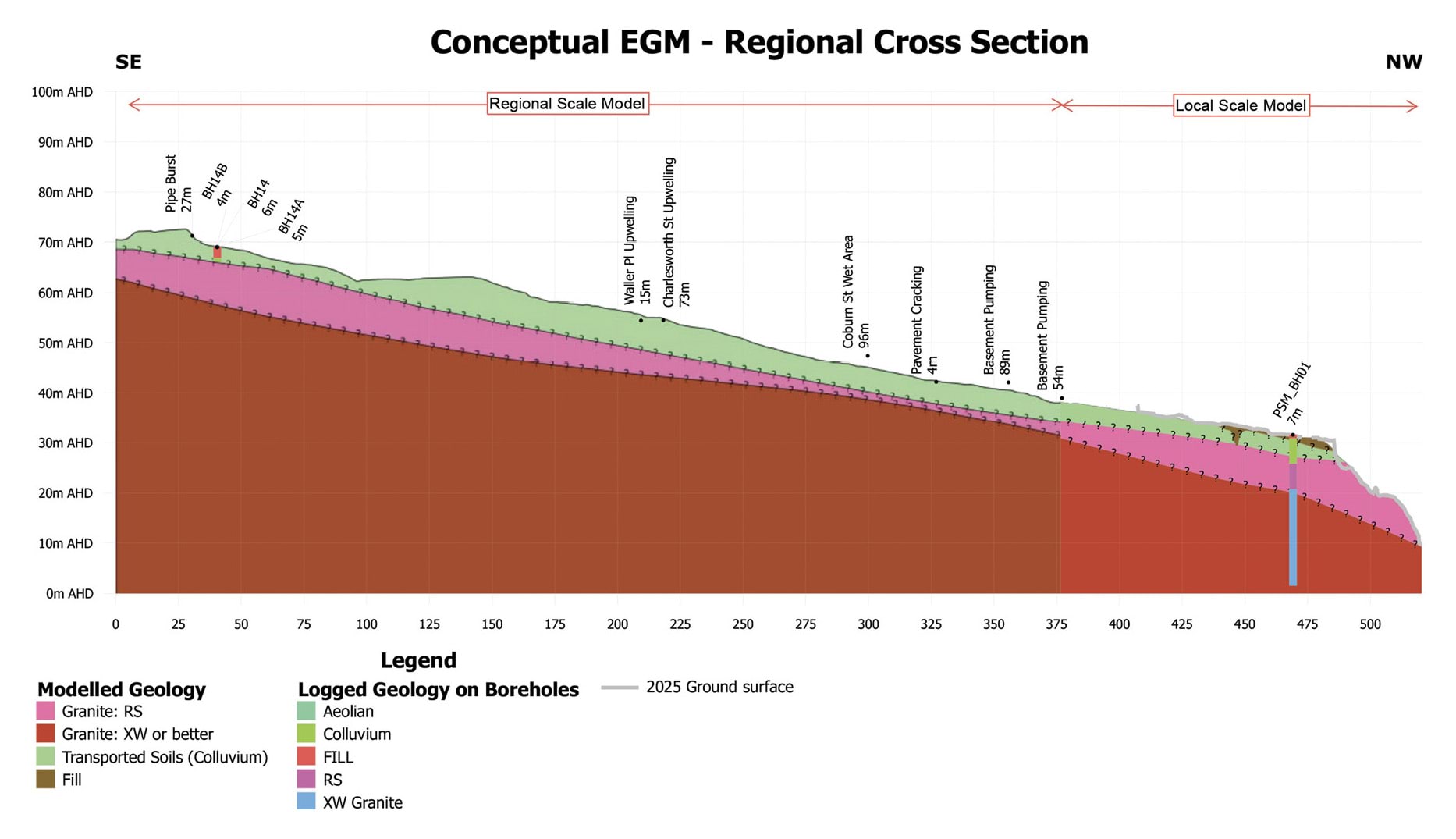
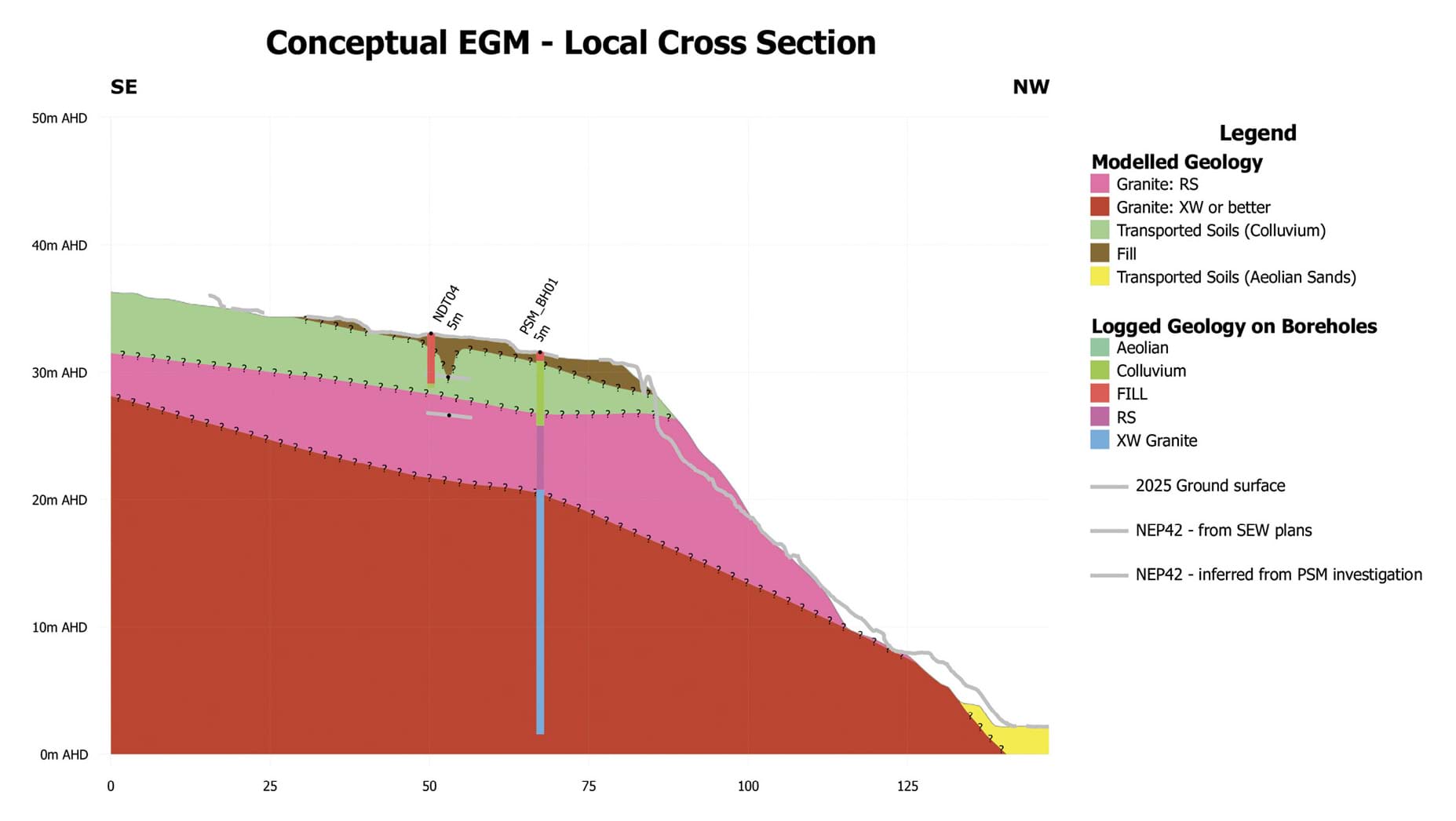
- Two cross sections of McCrae produced by WSP are of particular interest and are reproduced below. A regional one, extending from the foot of Arthurs Seat around The Boulevard to 3 Penny Lane and a local one, extending from approximately 23 Coburn Avenue to 3 Penny Lane. The cross sections show the relative positions of the residual granite (labelled “Granite: RS”), extremely weathered granite (labelled “Granite: XW or better”), transported soils (colluvium) and fill.
- The geotechnical experts produced effectively identical regional cross sections.21 However, the local cross sections gave rise to one area of dispute: the volume of fill on the slope above 3 Penny Lane.22 This dispute will be returned to later in this Chapter.
FIGURE 4.3: REGIONAL CROSS SECTION OF PSM’S CONCEPTUAL ENGINEERING GEOLOGICAL MODEL – THE BOULEVARD TO 3 PENNY LANE.23
FIGURE 4.3

FIGURE 4.4: LOCAL CROSS SECTION OF PSM’S CONCEPTUAL ENGINEERING GEOLOGICAL MODEL – 23 COBURN AVENUE TO 3 PENNY LANE.24
FIGURE 4.4

Water definitions and characteristics
- To properly address the second subsidiary question identified above – whether the chemical composition of water emanating from the headscarp can be used to identify its source – it is necessary to say something about groundwater and its characteristics.
- Generally speaking, the term “groundwater” can be used to describe any water that is held or travels underground.25
- Strictly speaking, however, groundwater has a particular meaning in hydrogeology, the scientific discipline concerning how water moves through subsurface pathways and interacts with the surrounding soil and rock.
- In its technical sense, groundwater refers to water that resides in an aquifer, being water-bearing layers beneath the ground surface. Aquifers vary in both their depth and their continuity of water supply. A permanent aquifer lies deeper underground and provides a constant supply of water, 26 whereas a shallow aquifer is closer to the surface and provides a more variable, often intermittent, supply.27
- “Regional groundwater” resides in the permanent aquifer for long periods. Its chemistry is therefore influenced by the aquifer material with which it comes in contact.28
- Contrastingly, “perched groundwater” is water in the shallow soils, which has infiltrated from the surface (typically from rainfall) or from a leaking water bearing service. Three points can be made about the characteristics of perched groundwater:
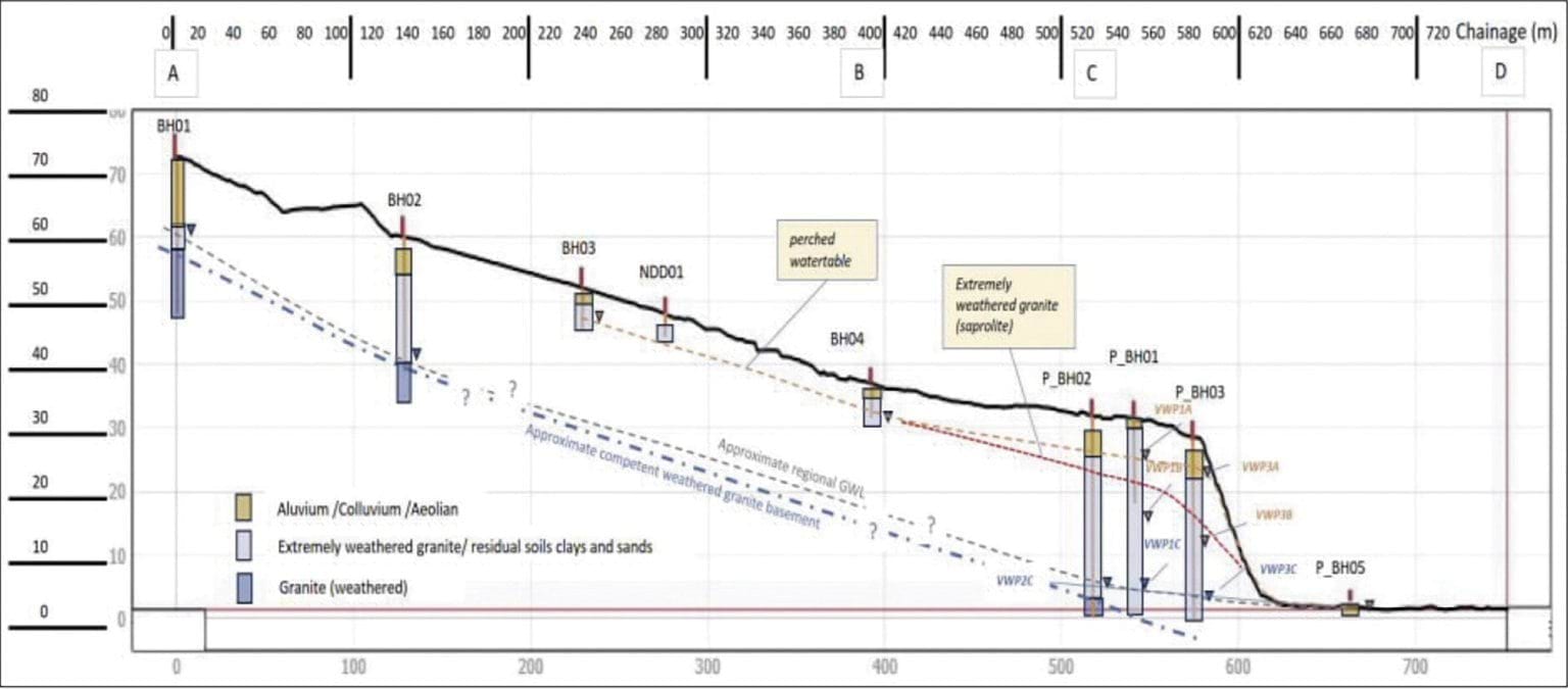
- The distinct locations of regional groundwater and perched groundwater in McCrae can be seen in the regional cross section prepared by SMEC (reproduced below). The regional groundwater is deeper underground, sitting just above the weathered granite “basement”. The perched groundwater is in the “perched water table” (or shallow aquifer) that sits closer to the surface.
FIGURE 4.5: INTERPRETATIVE HYDROGEOLOGICAL CROSS SECTION.32
FIGURE 4.5
- Increases in the volume of regional groundwater and perched groundwater (that is, “recharge”) occur in different ways:
- as to regional groundwater recharge, water enters at a recharge point (for example, a rock outcrop or ground surface) and then migrates vertically to the water table level in the permanent aquifer;33 and
- as to perched groundwater recharge, water volume increases through:
- infiltration of rainfall; and/or
- leakage of water bearing service infrastructure in the area, including stormwater, mains supply and sewage.34
- Both regional groundwater and perched groundwater can discharge through the surface at exit or exfiltration points called “springs”.35
- Having laid the foundation with these basic principles, it is now appropriate to turn to considering the causes of the landslides, starting with the November 2022 landslides.
4.4 What caused the November 2022 landslides?
- The November 2022 landslides occurred on the escarpment at the north-west end of 10–12 View Point Road on 14 and 15 November 2022.36 The more destructive of the two landslides occurred on the morning of 15 November 2022. It brought down at least 20 tonnes of soil and debris to the base of the escarpment.37 Two properties at the toe of the slope were damaged: 2 Penny Lane and 3/613 Point Nepean Road.38
- Both Mr Pope and Mr Paul agree that water triggered the November 2022 landslides.39 The key question is, therefore, what was the source of the water?
- Before turning to that question, three points should be made at the outset:
- first, the experts did not view the November 2022 landslides as having a causal relationship with the McCrae Landslide;
- second, the Shire’s submission in relation to the cause of the landslides only briefly touches on the cause of the November 2022 landslides;40 and
- third, the Board of Inquiry has not sought to determine the causes of the November 2022 landslides as an independent chain of inquiry in and of itself – that is beyond its Terms of Reference. Rather, the causes of the November 2022 landslides have formed the backdrop against which some of the experts have analysed the causes of the 5 January 2025 landslide and the McCrae Landslide. To that extent, the Board of Inquiry has had regard to, and considers it appropriate to address, the causes of the November 2022 landslides.
What was the source of the water that triggered the November 2022 landslides?
- The experts considered four potential sources of water:
- rainfall;
- groundwater from a shallow aquifer;
- a burst water main near 23 Coburn Avenue; and
- domestic water usage.
- Little needs to be said about two of those sources – groundwater from a shallow aquifer and domestic water usage – beyond noting their relative insignificance. Mr Pope and Mr Paul agreed, with a high level of confidence, that groundwater from a shallow aquifer was an insignificant trigger for the November 2022 landslides.41 Mr Paul did not assess whether domestic water usage was a trigger, and Mr Pope considered its effect to be insignificant to minor with low confidence.42
- More does need to be said about rainfall and the burst water main near 23 Coburn Avenue as potential sources, each of which will now be addressed in turn.
The water was the result of rainfall
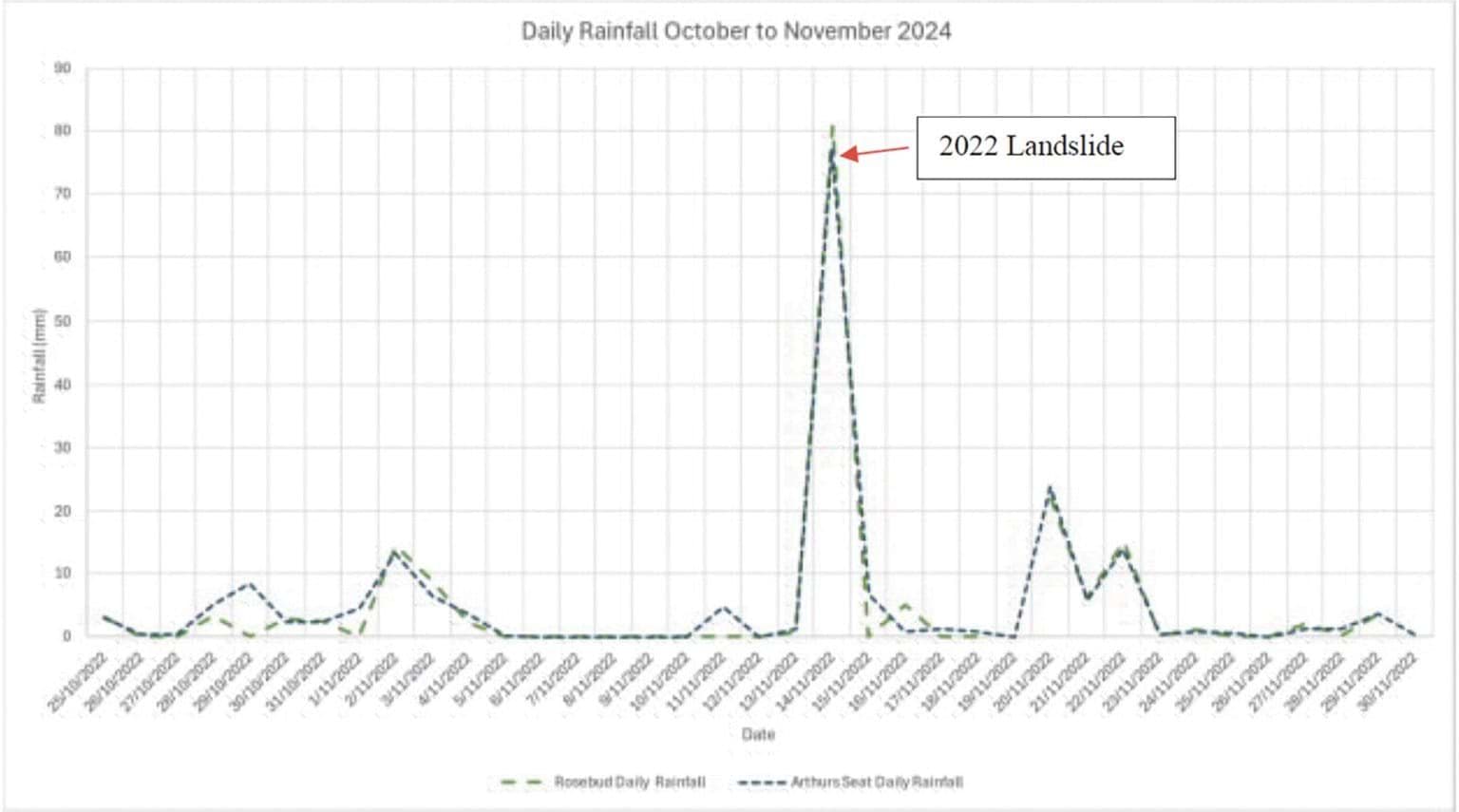
- A significant rain event occurred in McCrae the day before the 15 November 2022 landslide. Approximately 80 millimetres of rain was recorded at the Rosebud weather station, the closest rain gauge to McCrae, much of which fell within an eight hour period.43
- This was the fourth largest rain event on record.44 Mr Pope described the event as having a 1 in 100 year to 1 in 200 year probability of occurring within an eight hour window.45 Mr Paul described it as “anomalously high rainfall”.46
- The intense nature of the rainfall on 14 November 2022 is shown in the following graph:
FIGURE 4.6: DAILY RAINFALL TOTALS FOR THE PERIOD BETWEEN OCTOBER 2022 AND NOVEMBER 2022 FOR ROSEBUD (BUREAU OF METEOROLOGY) AND ARTHURS SEAT (MELBOURNE WATER).47
FIGURE 4.6
- It is no coincidence that the November 2022 landslides occurred shortly after this significant rain event. It is well-established that rainfall can trigger a landslide.
- Intense rainfall can cause water to infiltrate the ground and change the pressure between soil particles.48 If the space between soil particles (also referred to as pores) is filled with water, the increase in pressure exerted by the water can effectively “push” the soil particles apart.49 The increase in pore pressure can lead to a “tipping point at which soil strength is lost to the extent that a landslide is triggered”.50
- That tipping point was reached on the escarpment at 10–12 View Point Road.
- Mr Pope and Mr Paul gave evidence that the rainfall event was a major or significant triggering factor for the November 2022 landslides.51 The experts only differed in their level of confidence: Mr Pope expressed his opinion with high confidence,52 while Mr Paul expressed his opinion with moderate confidence.53
- Mr Pope stated:
[T]he Rain Event was a major contributor to the landslide. In my opinion the initial translational landslide [that occurred on 14 November 2022] and the subsequent debris flow [that occurred on 15 November 2022] is unlikely to have occurred had the Rain Event not occurred or had the Rain Event been of lower intensity.54
- Mr Paul stated:
The anomalously high rainfall on the day preceding [the] 15 November 2022 landslide gives cause to suspect rainfall as one of the sources of water that infiltrated into the ground and migrated to the escarpment causing the 2022 landslide, although the pathway along which water migrated is not certain.55
The Board of Inquiry accepts that water triggered the November 2022 landslides and that rainfall was a significant contributor to that volume of water. That much is obvious.
Finding
Water triggered the November 2022 landslides.
- What is less obvious is whether the rain alone or in combination with another water source – namely, the burst water main at 23 Coburn Avenue – triggered the landslides.
It cannot be determined whether some of the water originated from the burst near 23 Coburn Avenue
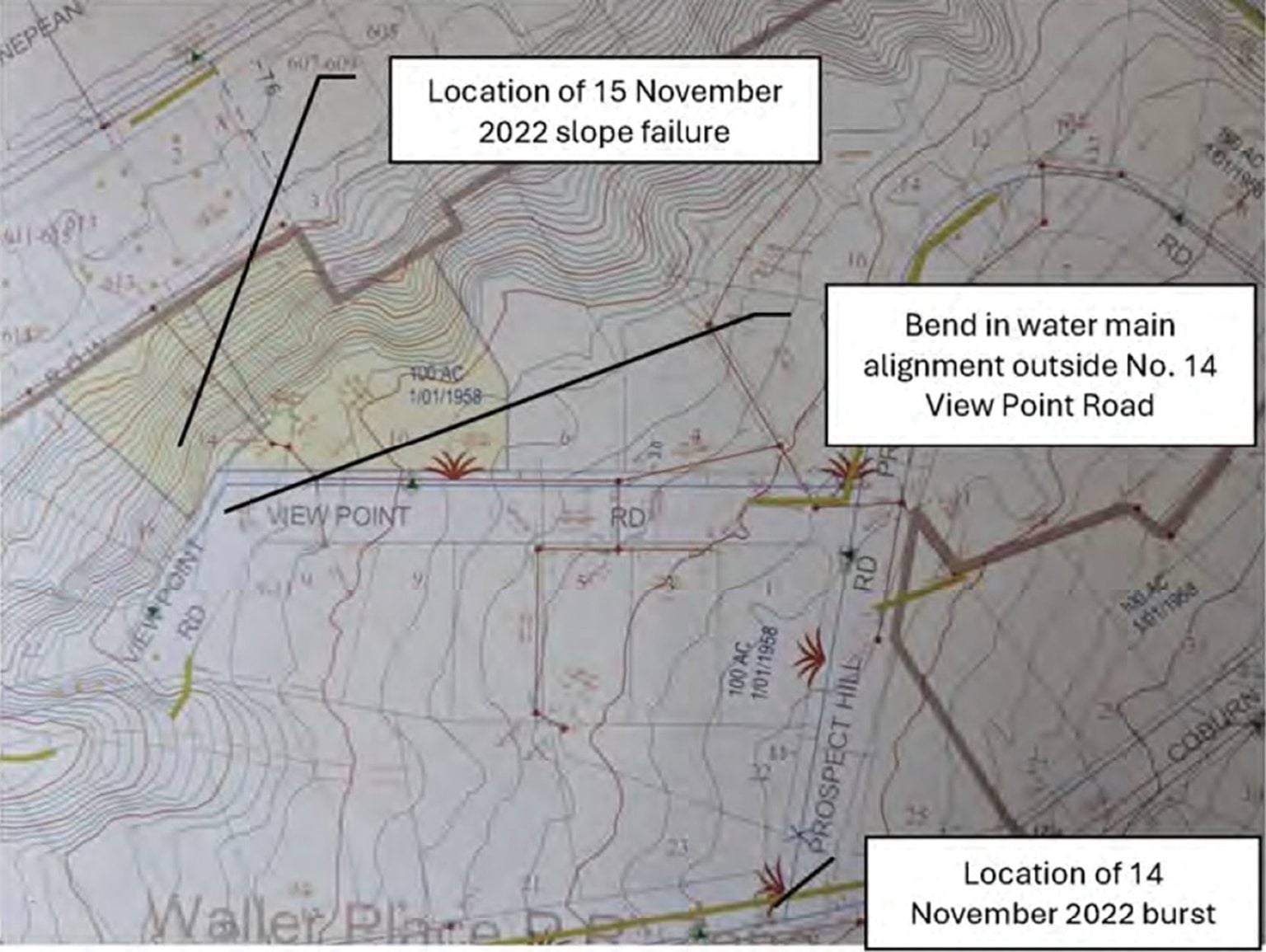
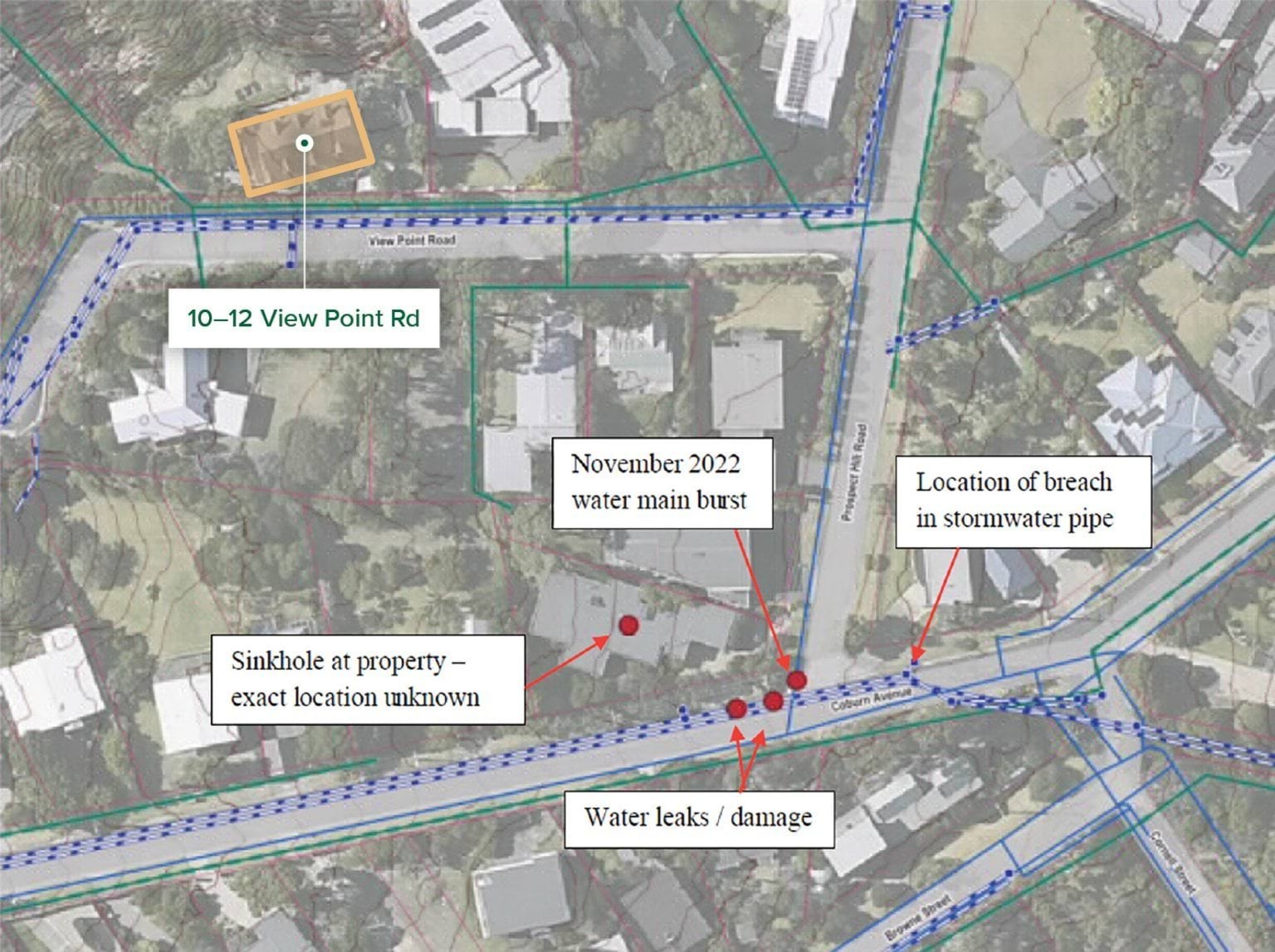
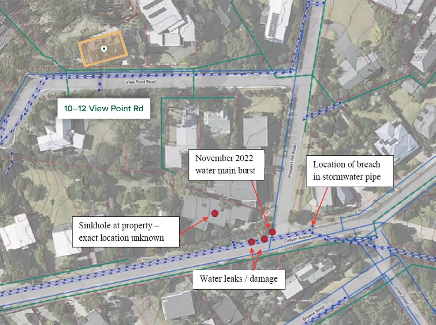
- At about 5.40am on 14 November 2022, a water main failed at the corner of Prospect Hill Road and Coburn Avenue,56 at approximately 23 Coburn Avenue.
- The asbestos cement pipe suffered two circumferential breaks along its length,57 allowing approximately 900,000 litres of water to be released prior to the main being turned off at 6.50pm.58 The water from the burst water main significantly compromised the road surface and nature strip. A large sinkhole appeared on Coburn Avenue to the great concern of multiple residents.59
- The failure occurred upslope of the site of the November 2022 landslides, as can be seen in the diagrams below.
FIGURE 4.7: LOCATION OF WATER MAIN BURST RELATIVE TO THE NOVEMBER 2022 LANDSLIDES.60
FIGURE 4.7
FIGURE 4.8: LOCATION OF WATER MAIN BURST AND OTHER OBSERVATIONS IN ITS VICINITY.61
FIGURE 4.8
- The distance between the burst water main and the landslide site was greater than 120 metres.62 Could water from the burst have travelled downslope and triggered the landslides?
- Only Mr Paul gave an expert opinion on this issue. Mr Pope said he was unable to comment.63 Mr Paul expressed, with low confidence, the view that water from the burst water main was a medium contributor to the November 2022 landslides.64 He explained:
Some of this water [from the burst water main] exfiltrated at the road surface near the leak, and some must have infiltrated the ground because the point of water exfiltration at the ground surface was about 5 m away from the burst location and the sinkhole had opened in the private property at 23 Coburn Avenue.
Whilst the water main leakage ... may not have been the direct trigger of the landslide on [15 November 2022,] due to the insufficient evidence on which to base it, I am unable to provide an opinion on the proportion of water from the burst compared to the proportion from rainfall that might have contributed to the [landslide]. It is possible that the burst caused wetting of the ground and helped to form subsurface pathways, making the ground at the escarpment more susceptible to landslide upon the extreme rainfall event[.]65
- SEW did not adduce any contrary expert opinion in response to Mr Paul’s evidence. However, it submitted that the expert evidence does not permit a finding that the burst water main triggered the November 2022 landslides.66 SEW pointed to a temporal issue and the paucity of evidence.
- As to the temporal issue, SEW highlighted that the burst occurred at approximately 5.40am on 14 November 2022 and was fixed at around 6.45pm on the same day. SEW submitted that there was insufficient time for any infiltrated water from the burst to reach the landslide site by subterranean means, assuming that the landslide on 14 November 2022 occurred at around 6.30am.67
- The difficulty with this submission is that it hinges on the loud cracking noise that Mr Willigenburg heard at 6.30am on 14 November 2022 as being conclusive evidence of when the landslide occurred. That is open to doubt. There is no other evidence corroborating that the noise signalled the occurrence of the landslide. Mr Willigenburg himself gave evidence that, upon inspecting the back of his property after hearing the loud cracking noise, he did not observe anything unusual.68
- In any event, the repair of the burst water main on the evening of 14 November 2022 does not preclude the possibility that part of the 900,000 litres of escaped water flowed to the landslide site and contributed to causing the more significant landslide on 15 November 2022.
- The Board of Inquiry, therefore, does not accept that the temporal issue is determinative.
- As to the paucity of evidence, SEW submitted that there is no evidence of the:
- volume of water that entered the stormwater drain, save for some photographs taken on 14 November 2022 of water flowing downhill of Coburn Avenue, away from Prospect Hill Road, into a stormwater drain in the kerb;
- volume of water that infiltrated the ground;
- flow path of any subterranean water; and
- precise location of the leak.69
- In the course of cross-examination by SEW’s Counsel, Mr Paul acknowledged that in forming his opinion, he had not personally undertaken tests to identify the underground channels from Coburn Avenue to View Point Road.70 He acknowledged that the connectivity between the burst water main and the landslide site was a “main [area of] uncertainty”.71 He also said that he had not seen evidence of how much water went down the stormwater drain.72
- There is no direct evidence before the Board of Inquiry concerning the volume of water that diverted down Coburn Avenue and into the stormwater drain as opposed to the volume that travelled through a subsurface flow path towards the landslide site. That does not, however, eliminate the possibility that a proportion of the water may have infiltrated the escarpment at 10–12 View Point Road.
- There is some evidence that the water did not entirely flow into the stormwater drain and, in fact, progressed down Prospect Hill Road. For example, as outlined in Chapter 3, at 10.36am on 14 November 2022, a resident at 22 Prospect Hill Road (next door to 23 Coburn Avenue) reported that the street stormwater pit was blocked, and that water was overflowing and flooding their house.73
- Nevertheless, the point remains that the experts and the Board of Inquiry are in no position to conclude with any degree of certainty the proportion of water from the burst water main that flowed towards the landslide site. As Mr Paul said, properly, there are too many “unknowns” considering the current evidentiary base.74 A more wide-ranging and in-depth investigation would have been necessary in order for the Board of Inquiry to be satisfied of the relevant facts; however, that was outside the Terms of Reference.
- The Board of Inquiry, therefore, draws no conclusions as to the extent to which the burst water main near 23 Coburn Avenue may have contributed to triggering the November 2022 landslides.
What were the preparatory factors that may have contributed to causing the November 2022 landslides?
- It will be recalled that preparatory factors are those which make the landscape more susceptible to landslide, even before a triggering event – like the intense rainfall of 14 November 2022 – occurs.
- The experts addressed five preparatory factors in relation to the November 2022 landslides, each of which can be dealt with relatively briefly.
Erosion of the escarpment
- The site of the November 2022 landslides was located on the prominent escarpment at 10–12 View Point Road. The escarpment is approximately 25 metres high, with an overall slope angle of 35 degrees.75
- To contextualise the steepness of the slope, Mr Borghesi gave evidence that one could “scramble down the entire area of the 2022 landslide” but that it was still “quite a steep slope, so you would tend to traverse it rather than use it”.76
- Both Mr Pope and Mr Paul agreed, with very high confidence, that erosion of the escarpment was a major or significant preparatory factor for the November 2022 landslides.77
Mr Pope explained that erosion had led to “marginally stable slope conditions, for which landsliding may occur”. He added that in the upper zone of the slope, the soil slope angle exceeded the effective friction angle of the soils, rendering the slope susceptible to landslides upon a change in soil moisture.78
Finding
Erosion was a significant preparatory factor for the November 2022 landslides.
Subsurface voids/piping channels
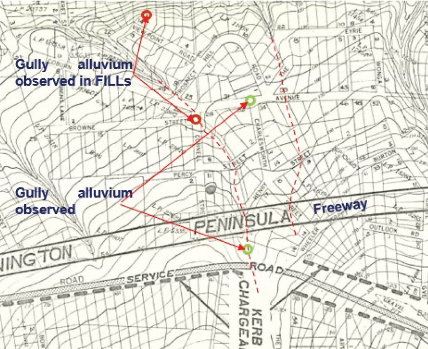
- As outlined in Chapter 3, in May 2023, the Shire commenced a major stormwater drainage improvement project along View Point Road. During the excavation process, a “substantial void” was revealed directly upslope of the location of the November 2022 landslides.79
- It was common ground between the experts that a void existed. Ground penetrating radar testing conducted in December 2023 along View Point Road confirmed the existence of a void “approximately 550mm below ground surface and 450mm deep (1.0m below ground surface)”.80 The full extent of the void was unable to be mapped, but it minimally extended from the kerb line to the sewer line along 10–12 View Point Road.81 Mr Paul assumed the correctness of, and relied on, this evidence.82 Mr Pope agreed that the presence of the identified “void in a recently excavated stormwater trench is consistent with natural voids observed in the escarpment”.83
- What divided the experts was whether the void had acted as a preferential channel for water, leading to the saturation of the escarpment prior to the November 2022 landslides. On the one hand, CivilTest, geotechnical engineers engaged by the Borghesis in November 2022, concluded that the void had provided a pathway for water towards the headscarp area.84 It was also CivilTest’s opinion that the cracked kerbs along View Point Road allowed for water from the rain event to accumulate and build up below ground.85 Mr Paul and Mr Pope were not able to express a confident view about that matter. They expressed, with a low level of confidence (less than 40%), that the void was a significant (for Mr Paul) or minor (for Mr Pope) preparatory factor for the November 2022 landslides.86
- Both Mr Paul and Mr Pope were constrained by the evidence available. Mr Paul identified two key gaps in the evidence: he did not know to where the void led, nor did he know whether there were other voids in the area.87 It is, however, important to note that the effect of Mr Paul’s evidence is that the subsurface voids may have been a “significant” preparatory factor. It is also important to recognise that Mr Pope has only low confidence that the voids were a minor preparatory factor. As to his low level of confidence on the issue, Mr Pope said that the “orientation of the void is unknown”, but he expected it to be consistent with groundwater flow directions and perpendicular to the escarpment or parallel with the sewer trench.88 Moreover, he noted that he had not observed any direct evidence of “connectivity” between the void and the landslide site.89
- Without the benefit of a more comprehensive evidence base, the Board of Inquiry draws no conclusions as to whether subsurface voids were a preparatory factor for the November 2022 landslides. The Terms of Reference constrained a deeper inquiry into the issue.
Groundwater from a shallow aquifer
- The Board of Inquiry heard extensive evidence from the Borghesis about the continuous flow of “spring water” down the fractured and cracked northern kerb of View Point Road, and a general increase in the saturation of the hillside in the location of the November 2022 landslides. These observations were made from May 2014 and particularly in the period between December 2020 and May 2023.90
- The increased saturation was so significant that Mr Borghesi installed “agi drains” across the hillside pathway in July 2021 to redirect water, control erosion and make the pathway down to Penny Lane trafficable.91
- CivilTest opined that the Borghesis’ observations of natural seeps on the slope constituted “strong evidence of perched water forming at the materials interface due to the soil profile and topography of the area”.92 It concluded that “[p]erched water had built up at the material interface ... which led to a lack of friction and cohesion at the interface of [the] materials”.93
- Both Mr Pope and Mr Paul were less definitive in their opinions. Mr Pope expressed the view, with moderate confidence (40%-<60%), that groundwater from a shallow aquifer was a medium preparatory factor for the November 2022 landslides.94 He acknowledged that groundwater seepage provides a direct source of water which can contribute to increases in soil moisture content, and appeared to accept that the seeps were likely to be partly associated with natural springs further upslope.95 Mr Paul provided no opinion on this preparatory factor as he had “not seen evidence for a spring or natural conveyance of water to the location of the 2022 landslides”.96
In view of the above, the Board of Inquiry accepts that the site of the November 2022 landslides was saturated for some time prior to the landslides. However, in light of the state of the expert evidence and the limit in the Terms of Reference, it draws no conclusions as to the extent to which groundwater from a shallow aquifer was a preparatory factor for the November 2022 landslides.
Finding
The site of the November 2022 landslides was saturated for some time prior to the landslides.
Anthropogenic changes
- Several anthropogenic changes were identified in relation to the site of the November 2022 landslides. Namely, Mr Pope observed the presence of paths, retaining walls and stairs above the site, which he considered allowed “surface water from outside the Landslide area to concentrate and direct flow into the Landslide site”.97 He further observed that three subsurface “agi-drains” discharged water onto the slope above the site,98 providing an additional source of infiltration that reduced slope stability.
- In the result, Mr Pope expressed, with moderate confidence, that such anthropogenic changes made a medium contribution, whereas Mr Paul, with low confidence, considered their contribution to be minor.99
- Overall, anthropogenic changes were given brief treatment as a preparatory factor for the November 2022 landslides and were not explored in detail in the public hearings due to the limit in the Terms of Reference. The Board of Inquiry, therefore, draws no conclusions in relation to their contribution to the November 2022 landslides.
Loss or removal of vegetation
- Finally, the experts considered the extent to which removal of vegetation from the escarpment may have contributed to the November 2022 landslides.
- Initially, Mr Pope considered this factor to be significant. In a report he prepared for legal proceedings in June 2024 on the causes of the November 2022 landslides, he stated:
I note that trees have been removed in 2021 including a large mature gum and further vegetation has been removed by the Landslide[.] In my opinion tree removal is a significant conditional event that has occurred at the Site and suction will change in the escarpment slopes ... In my opinion the Landslide Area is well within the influence zone of removed trees.100
- During examination by Counsel Assisting, Mr Pope accepted that his conclusions concerning the extent of vegetation removal may have been expressed too conclusively, saying that the tree line had changed, but he was not able to say whether the trees had been heavily pruned or removed altogether.101
- Ultimately, Mr Pope expressed, with high confidence, that removal of vegetation had a medium to major contribution.102 He explained that his level of confidence was supported by his examination of aerial photographs as well as three-dimensional models of the subject area.103
- Mr Paul agreed that removal of vegetation had a medium contribution but expressed this opinion with very low confidence.104 He explained that his assessment was based on historical images and photographs, which made it “quite hard” for him to determine the extent of root removal.105 In his view, this was more relevant to assessing slope stability than the extent of visible canopy cover in a photograph.106
- Mr Pope disagreed. He stated that a tree’s capacity to draw water up from the soil is directly linked to the canopy size, making it unnecessary to identify details of the affected root systems to assess the impact on slope stability.107
- The Board of Inquiry is not able to resolve the conflict given that this factor was not extensively explored in evidence due to the limit in the Terms of Reference. The Board of Inquiry did not have, for example, evidence from a witness with sufficient expertise in water suction through vegetation. It draws no conclusions in relation to the contribution of loss of vegetation to the November 2022 landslides.
Conclusion on the November 2022 landslides
- Water – from an intense rainfall event or in combination with water from a burst water main – triggered the November 2022 landslides. It may also be that the subsurface voids, in combination with the poor drainage and cracked kerb in View Point Road, were significant preparatory factors, and that loss of vegetation also played a role.
- Beyond making these observations, it is neither appropriate, nor necessary, to draw conclusions about the causes of the November 2022 landslides given the limitations imposed by the Terms of Reference. The Board of Inquiry is conscious of the pressing need, after almost three years, for there to be a resolution between the Shire and affected residents in relation to these landslides. While the Terms of Reference constrained the Board of Inquiry, there is no need for the mediation process that has been recommended (Recommendation 1) to be similarly constrained.
- The November 2022 landslides form an important part of the backdrop to the 5 January 2025 landslide and the McCrae Landslide. It cannot be forgotten that all of those landslides predominantly occurred on the same property, albeit on different parts of the escarpment. Moreover, while the intense rainfall event was unique to the November 2022 landslides, water again played a significant role in triggering the 5 January 2025 landslide and the McCrae Landslide. It is to this central issue that the Report now turns.
4.5 What caused the 5 January 2025 landslide and the McCrae Landslide?
- An issue of central significance for the Board of Inquiry was the cause of the McCrae Landslide. On this question, the Board of Inquiry had the benefit of extensive expert geotechnical, hydrogeological and geochemical evidence.
- Although there is no doubt that the 5 January 2025 landslide and the McCrae Landslide were causatively related, the Board of Inquiry investigated the cause of each landslide independently. Critically, the Board of Inquiry did not proceed from the assumption that the McCrae Landslide was caused by the same factors as the 5 January 2025 landslide, or that the earlier landslide itself caused the later one.
- Even on that approach, it quickly emerged that the causes of the two landslides could not be disentangled. The landslides, to borrow Mr Paul’s language, “can be considered separate stages of the one landslide event”.108 Consequently, much of the analysis that follows applies to both landslides.
- With that in mind, the causal analysis for the 5 January 2025 landslide and the McCrae Landslide is as follows.
- On one point of significance there was unanimous agreement by the experts: the trigger for the landslides was excess water in the slope in the vicinity of 10–12 View Point Road.109 The origin of that water was disputed.
- All experts other than those engaged by SEW (being, Mr Paul, Dr Vu, Mr Makin, Mr Pope and Mr Hitchcock) considered that the water originated from a burst water main located near the corner of Bayview Road and Outlook Road. SEW’s expert, Mr Hartley (assisted by Mr Bolton and Mr Jewell), considered that the burst water main was not the source (and accordingly considered it to be a minor, or even insignificant, cause).
- Because water is accepted by all experts to be the trigger for the 5 January 2025 landslide and the McCrae Landslide, other common landslide triggers can be put to one side. Three potential water sources were identified:
- the burst water main;
- groundwater from an aquifer; and
- domestic irrigation.
- The preponderance of expert opinion was that the burst water main was the source of the excess water in the slope. All experts ruled out groundwater from an aquifer as a cause of any significance.110 SEW’s experts, Mr Hartley and Mr Bolton of SMEC were the only experts who considered domestic irrigation to be anything other than a minor cause.111
- It was important for the Board of Inquiry’s investigation to receive an opinion from SEW’s experts, which diverged from the views of all other experts. The provision of the contrary opinion served to rigorously test the prevailing expert consensus and has given the Board of Inquiry increased confidence in its conclusion that the burst water main was the source of the water.
The water originated from SEW’s burst water main
- As discussed in Chapter 3, SEW accepts that there was a long-running and substantial leak from the burst water main, which commenced around August 2024. In determining whether some of that water reached 6 and 10–12 View Point Road, the following issues arise for consideration:
- What was the volume of water lost from the burst water main?
- What were the available paths of travel for the burst water?
- Did water from the burst water main get to those flow paths?
- Do those flow paths convey water to the site of the January 2025 landslides?
- Do the observed conditions along each path support the flow of water along them?
- What volume of water travelled along each path?
- Did water from the burst water main make it to the slope?
- Each issue is considered in turn. The analysis is necessarily technical and detailed.
What was the volume of water lost from the burst water main?
- There is no doubt that a very significant volume of water escaped from the burst water main. SEW undertook various calculations to determine the likely extent of the leakage and, ultimately, engaged Professor van Zyl to opine on various matters connected with the burst.
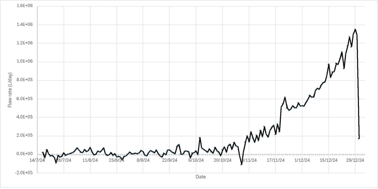
- Relying on analysis prepared by Dr Jonathan Crook, Group Manager for Analytics and Performance of SEW, Professor van Zyl estimated that the leak commenced in around the start of August 2024 and ceased on 1 January 2025 when the burst was repaired, and that the total volume of water that escaped from the burst water main was 40.3 million litres.112
- Professor van Zyl estimated that the flow rate of the leak progressively increased over time, rising sharply throughout December 2024, and peaking at approximately 1.4 million litres per day in late December 2024. Professor van Zyl graphically represented this flow rate as follows:
FIGURE 4.9: PROFESSOR VAN ZYL’S FLOW RATE ANALYSIS.113
FIGURE 4.9
- Professor van Zyl modelled leakage volume per day between 11 August and 31 December 2024. On that model:
- from 11 August until sometime in mid-October, around 11,000 litres per day was lost;
- from mid-October, that loss increased to around 50,000 litres per day;
- by November, it had risen to 160,000 litres per day;
- by the end of November the volume reached 560,000 litres per day;
- by mid-December, about 1 million litres per day was escaping the pipe; and
- finally, by the end of December, the leakage had risen to approximately 1.4 million litres per day.
- The Board of Inquiry has assumed the correctness of Professor van Zyl’s conclusions as to the total water loss and maximum daily flows in its consideration of the cause of the January 2025 landslides.
- The next question is: where did that water go?
What were the available travel paths for the burst water?
- Three potential flow paths for the water were considered by the experts:
- through sewer and water mains trenches, including through the permeable embedment (or bedding) materials;
- through the stormwater system; and
- through the shallow aquifer in the colluvium.
- The plausibility of each flow path falls to be considered across two geographical segments:
- at the site of the burst water main; and
- between the burst water main and the escarpment at 10–12 View Point Road.
- Before turning to the hypothesised paths, something needs to be said about how water moves through different materials. This topic was addressed in several of the expert reports and during the course of the public hearings. The evidence in its critical respects can be summarised as follows:
- Ordinarily, water travels downward with gravity, following the path of least resistance.114
- Water on the ground surface, will either infiltrate that surface if it is permeable (e.g. soil), or otherwise flow over that surface following the path of least resistance downhill until it reaches a permeable surface.115
- “Permeability” is the ability of a material to absorb or transmit a given volume of water. “Hydraulic conductivity” is the rate at which water moves through a given material in metres per second. This can be used to compute the “linear velocity” of water using Darcy’s Law, which states that the discharge rate is proportional to the hydraulic gradient and the hydraulic conductivity.116
- Where the volume of water per minute infiltrating a given area of soil exceeds the amount of water that can pass through that area in the same minute, that water will pool on top of the soil and spread out across it.117
- When water infiltrates permeable materials, it will travel until it reaches a low permeability layer that limits its migration.118 If resistance to subsurface flow is too high for more water to be absorbed, water will be forced to the surface (exfiltration).119
- As water follows the path of least resistance, it will tend to travel through materials of relatively high permeability as the “preferential pathway”.120 The more granular the material, the more permeable (i.e., the greater “pore spacing”) it is and therefore the more likely to be a preferential pathway.121 Gravels are typically more granular than sands, which in turn are more granular than clays. This is why gravels are typically used for drainage.122 To give some more specific numbers for context, SMEC concluded here that the velocity of the embedment material in service trenches was approximately 10 minutes per metre travelled, whereas the natural soil (colluvium) velocity was 12 hours per metre travelled (two metres per day).123
- In order to understand whether water could have travelled the hypothesised paths to the landslide site, it is first necessary to start with the site of the burst. That is where water was immediately discharged and, therefore, the immediate surrounds of the water main are of relevance to the question of where water would have migrated. It is also necessary to provide a broad overview of the flow paths considered by the experts before descending into the detail.
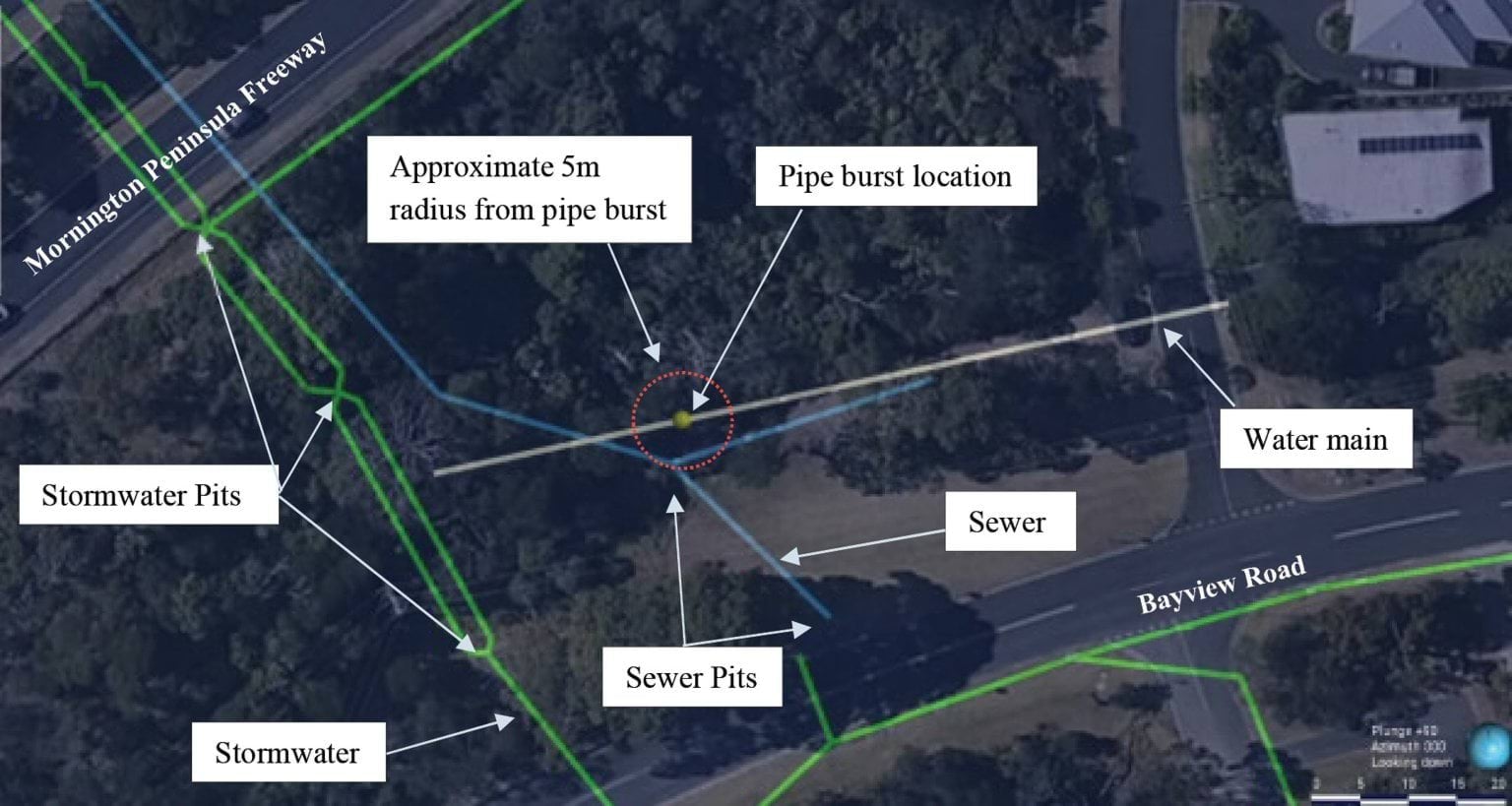
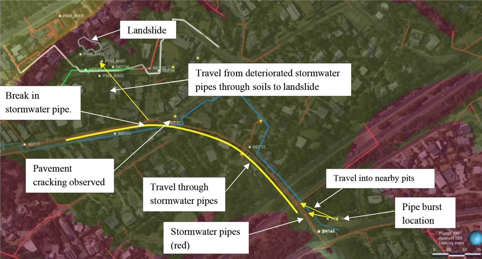
Burst water main site
- The burst occurred in dense bushland located between Bayview Road and the Mornington Peninsula Freeway.
- The image below is an overhead photograph of the burst location, annotated to identify key features of relevance. In particular, it shows the position of the burst in relation to nearby mains water, stormwater and sewer infrastructure. The annotations show that the burst occurred several metres from a sewer trench and stormwater pipes, which run downslope under the Mornington Peninsula Freeway toward the escarpment on which the January 2025 landslides occurred.
FIGURE 4.10: OVERVIEW OF THE BURST SITE SHOWING THE APPROXIMATE LOCATION OF WATER SERVICES.124
FIGURE 4.10
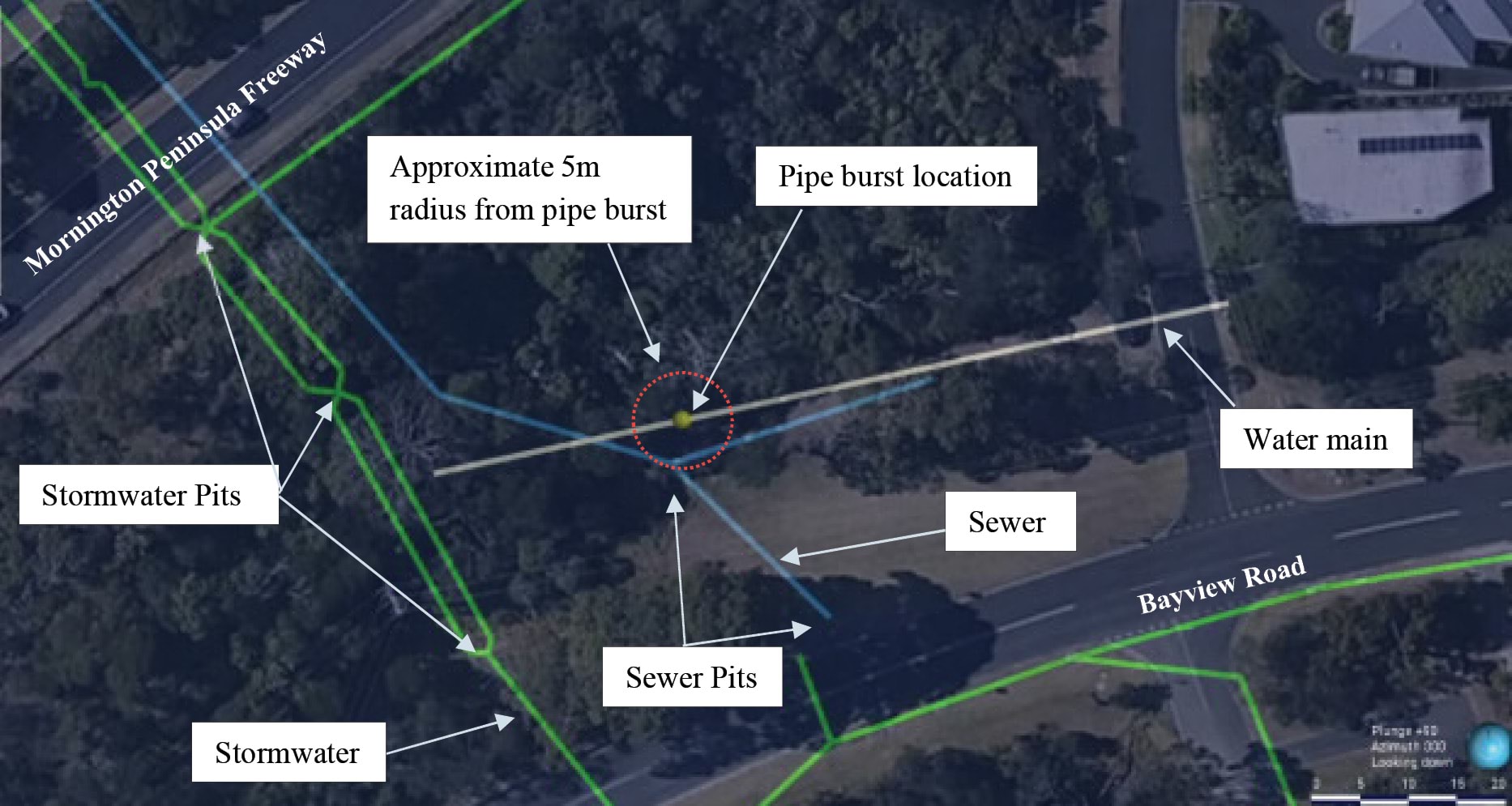
- The respective orientation of the burst location, sewer and stormwater trenches are shown in the image below, which is an isometric view of the burst site:
FIGURE 4.11: ISOMETRIC VIEW OF THE BURST SITE SHOWING THE APPROXIMATE LOCATION OF WATER SERVICES.125
FIGURE 4.11
- The subsurface geological units in which the infrastructure is found are represented in different colours. The water main and sewer pipes are in the relatively permeable transported soils (green), which sit on top of residual granites (mauve). The implications of this for the extent and velocity of water flow will become apparent.
- Having identified the locational features of the burst site, it is then necessary to briefly return to the three potential flow paths, being through:
- sewer and water mains trenches, including through the permeable embedment or bedding materials;
- the stormwater system; and
- the shallow aquifer in the colluvium.
- There was substantial agreement between the experts both as to the existence of the flow paths, and the fact that water from the burst had travelled through them. SEW’s experts disagreed, however, with the other experts on where the water ultimately travelled.
- Mr Paul concluded that some of the water from the burst reached the site of the January 2025 landslides, travelling through soils, fill, trench backfill and possibly breaches in the stormwater systems.126
- He considered the burst water main was the only source capable of supplying the volume needed to trigger the landslides and to explain the post-landslide flows observed at the headscarp. He did not reach a firm view on which pathway or pathways the water followed, considering all three to be plausible.127
- Mr Pope independently reached the same conclusion as Mr Paul – that water from the burst water main triggered the 5 January 2025 landslide.128 As to how the water travelled to that location, Mr Hitchcock initially expressed the opinion that the colluvial channel flow path (shallow aquifer) was the most likely pathway by which water would have travelled.129 However, during the concurrent expert evidence hearing, he explained that after considering the other expert reports, which he had not seen before producing his report, he thought it was more likely that the water flowed through a combination of the colluvial channel and the stormwater and sewer bedding materials.130
- SEW’s expert, Mr Hartley, agreed with the presence of the flow paths from the burst water main, however, disagreed that water would have flowed through them to the site of the January 2025 landslides. Mr Hartley summarised his findings about flow paths as follows:
A proportion of mains water flowing overland from the Bayview Road leak would have permeated into the surrounding soil, flowing toward the escarpment as groundwater. The two paths likely taken by the leak water to travel downslope as groundwater comprise:
- Flow through the shallow soil aquifer only (i.e. through natural soil and fill soil, excluding embedment material) following groundwater flow paths; and
- Flow through the shallow soil aquifer, then into utility trenches filled with embedment material and then flowing downhill to the sea.
While these two flow paths are not mutually exclusive, and Bayview Road leak water would likely have taken both paths, we assess that the majority of the mains water derived from the leak (that didn’t enter the stormwater system) will have travelled downslope within existing service trenches. This is because the utility trenches – with relatively higher permeability than natural material – intercepts and absorbs the intercepted groundwater flowing through the shallow soil aquifer.131
- During the concurrent expert evidence hearing, Mr Hartley’s opinion about the sewer trenches flow path was clarified, as follows:
The idea that water flows through the sewerage trench down through - underneath the M11, Waller Place, Charlesworth, hits Coburn, is very much something that we think is a high likelihood and what we’ve been able to do - and it gets all geochemistry breadcrumby from thereon - is understand that there is a trend of water with similar characteristics that go down the sewerage down to Coburn Avenue, then get into the natural material and find themselves underneath the property in the agi-drain system of 7 Prospect Hill Road.132
- Despite agreeing about the existence of the flow paths, SEW’s experts, Mr Hartley and Mr Bolton, did not agree that water from the burst water main was the trigger for the 5 January 2025 landslide (or, for that matter, the McCrae Landslide).133 Mr Hartley and Mr Bolton stood apart from Mr Paul, Mr Pope and Mr Hitchcock in this respect.
- Having provided a broad overview of the available flow paths, it is necessary to consider more detailed evidence in respect of those flow paths.
- There is no escaping that the evidence concerning the flow paths is complex. It is therefore necessary to step through the analysis in stages. At the first stage, this Chapter examines the flow paths in the immediate vicinity of the burst water main. At the second stage, it examines the flow paths between the burst water main and the site of the January 2025 landslides.
Water infiltrating directly from the burst water main into embedment materials of the water main service trench and the nearby sewer trench
- Turning to the first stage, at its simplest, the water, on immediately escaping from the burst water main, had two possible directional paths: upward to the surface or downward into the ground. That proposition requires some unpacking.
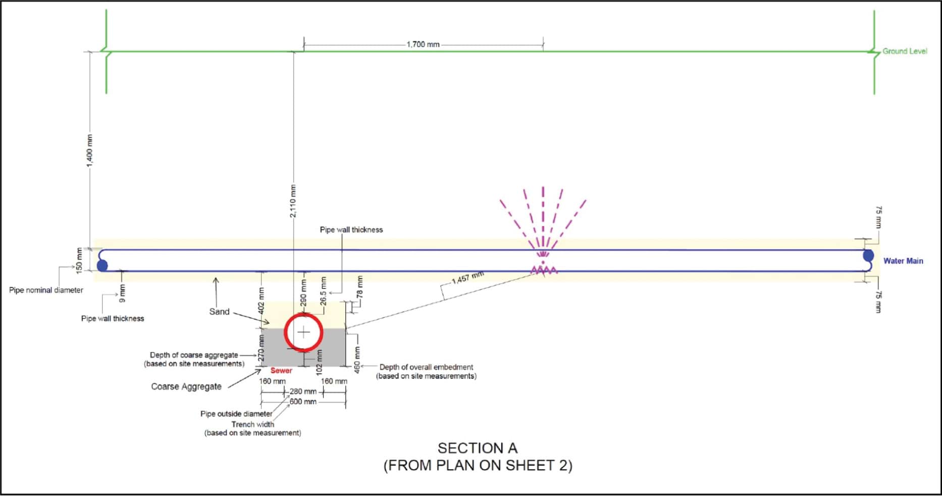
- As can be seen from earlier diagrams of the burst site (Figures 4.10 and 4.11), close-by to the water main, is sewer main NEP39. That sewer main sits approximately 1.5 metres below and to the side of the water mains trench in which the burst main was located. The following cross-sectional diagram illustrates the point:
FIGURE 4.12: SUBTERRANEAN CROSS SECTION OF THE BURST SITE.134
FIGURE 4.12

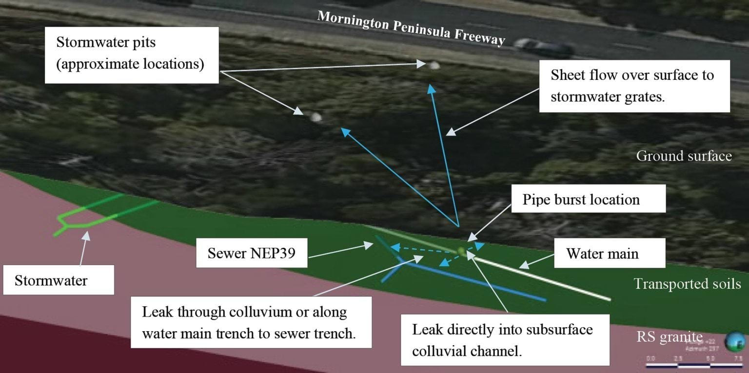
- Professor van Zyl provided an annotated version of the above diagram showing his opinion of the multiple flow paths from the burst:
FIGURE 4.13: ANNOTATED DIAGRAM ILLUSTRATING PROF VAN ZYL’S OPINION REGARDING FLOW PATHS NEAR THE BURST SITE.135
FIGURE 4.13

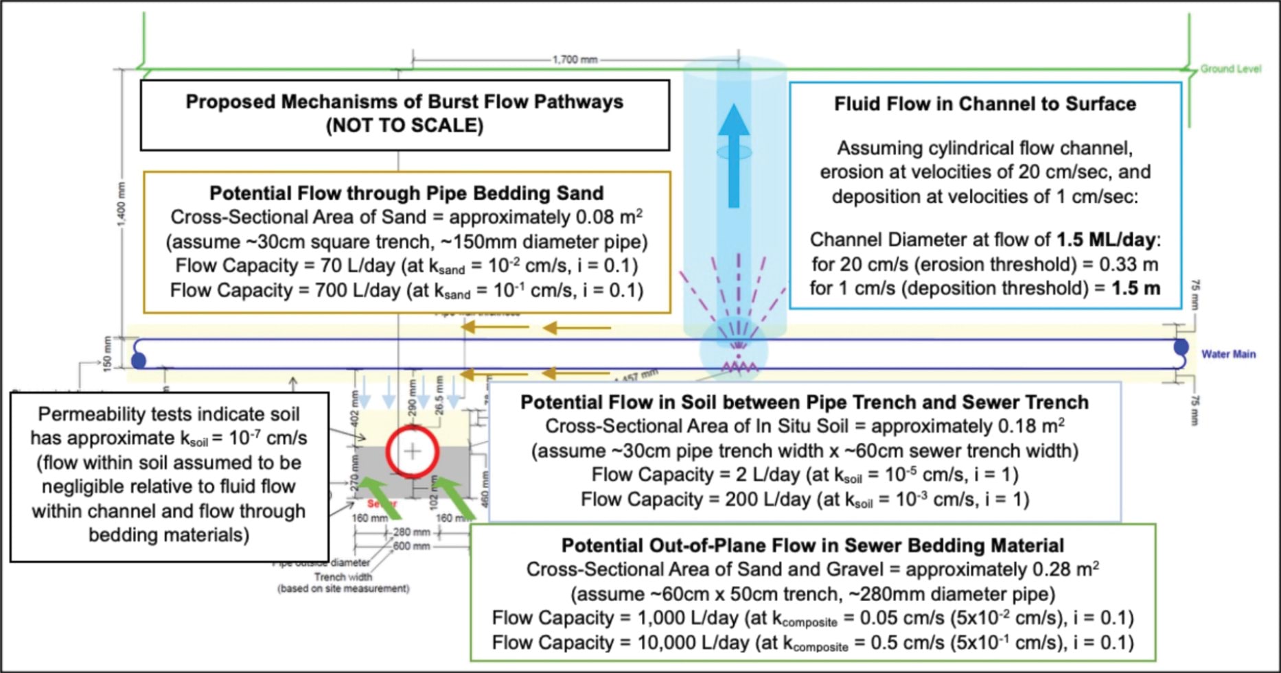
- As the diagram depicts, Professor van Zyl identified four flow pathways, one of which is vertical and three of which are lateral. As to the former, water from the burst could have travelled vertically upwards through a “Fluid Flow Channel” to the surface (Vertical Burst Channel). As to the latter, water from the burst could have travelled through the:
- bedding material of the water main, which was assumed to consist of sand;
- soil between the water main and sewer trench; or
- sewer bedding material, which was assumed to consist of gravel below the pipe and sand above the pipe.136
- Professor van Zyl’s opinion was that water from the burst main would have first infiltrated the water main’s sandy bedding material but, due to the relative impermeability of that material, it would also have begun to infiltrate the surrounding soils. From here, Professor van Zyl considered the water from the burst would have begun to form the Vertical Burst Channel, while, at the same time, continuing to spread through the soil and ultimately reaching the sewer service trench, which was comprised of sand and gravel. It is important to note the amount of water exiting from the burst pipe initially (i.e. in the first two months) was not enough to overcome the permeability of the mains and sewer service trenches.137 Once the volume of water was too great to be absorbed through these paths, the Vertical Burst Channel was formed and the water began to flow to the surface.138 As is explained below, the water that followed the Vertical Burst Channel to the surface is the source of the water for the recharge of the colluvial channel and stormwater flow paths to the site of the January 2025 landslides.
- On the question of how much water flowed through the bedding materials, Professor van Zyl provided “sample” calculations of the expected flow rates through the water main and sewer bedding materials. His estimate was a flow rate of 11,000 litres per day, of which 10,000 litres per day travelled through the sewer bedding material, and 1,000 litres per day travelled through the surrounding water main bedding material.139
- Professor van Zyl did not give oral evidence, nor did he participate in the expert conclaves. Rather, his report was sought by SEW and relied upon by Mr Hartley and Mr Bolton in forming their conclusions. Mr Hartley and Mr Bolton could not explain why Professor van Zyl referred to his calculations as a “sample”, nor did they attempt to verify the professor’s figures.140
- There were no alternative calculations for the flow rates Professor van Zyl calculated, however, Mr Pope considered Professor van Zyl’s figures to underestimate the likely permeability of the materials between the sewer and water main trenches.141 Mr Pope estimated that “relatively low heads (~0.5 m) flow through gravel bedding in sewer trenches may be in the order of 15 to 20 litres per minute or 21,600 to 28,800 litres per day”,142 roughly twice to three times Professor van Zyl’s 11,000 litres per day.
- Setting aside the concerns with the accuracy of Professor van Zyl’s estimate (without intending any criticism, given that he did not appear in person), the effect of his “sample” calculations – which may well be a conservative estimate – was that before the water from the burst water main reached the surface, at a minimum, approximately 11,000 litres per day would have been absorbed into the mains and sewer trenches from 11 August 2024.
- It will be recalled that the water main and its trench is situated in transported soils (colluvium).143 As to whether the water travelled through the colluvium – the soil between the water main and sewer trench – Professor van Zyl stated:
[S]eepage through the in-situ soil was assumed to be negligible relative to the flow capacities of the higher permeability bedding materials and the fluid flow channel developing between the pipe burst and ground surface (the assumption of relatively low seepage flow rates through the in-situ soil is supported by the measured permeability values).144
- In summary then, at least 11,000 litres per day (and possibly as high as 28,800 litres per day) of water from the burst water main was travelling directly from the burst into the surrounding water main bedding and nearby sewer main bedding. The balance reached the surface through the Vertical Burst Channel.
- What happened to the balance of the water that reached the surface via the Vertical Burst Channel?
Colluvium and stormwater flow paths
- As noted above, on Professor van Zyl’s analysis, the water from the burst main took about two months to reach the surface via the Vertical Burst Channel. Prior to this, the majority of the water was infiltrating the service trenches. That the water from the burst did not reach the surface until approximately 6 October 2024, was due to flow capacity for the service trench materials not being overwhelmed until that point.145
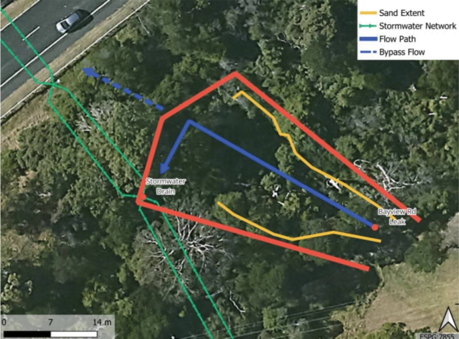
- What happened to the water once it reached the surface was considered by Tim Rhodes, Technical Principal of SMEC.146 He prepared a two-dimensional hydraulic model that simulated flows across the terrain between the burst location near Bayview Road and the nearby stormwater drains.147
- Mr Rhodes explained that as the volume of water reaching the surface increased, it began to fan out over the surface of the ground, flowing downhill toward the stormwater drain located about 30 metres from the burst site.148
- The extent of the surface water flow was estimated to be delineated by the extent of sandy materials deposited across the surface downslope of the burst site.149
- The diagram below illustrates the observed sand flow (delineated by the red lines) fanning out from the burst location towards the stormwater drain, and inferred to have been transported there by the surface water flow.150
Landslide Report
- Mr Rhodes estimated the surface area inundated by the surface flow to be around 400 square metres.151
- Once the water surfaced, it followed one of two pathways: a portion infiltrated (back) into the ground as it travelled downslope, while the residual made its way into the stormwater system via the stormwater drain.
- Mr Rhodes provided the Board of Inquiry with evidence of the proportion of water that infiltrated the ground. He estimated that by applying an infiltration rate (based on the surface permeability) of 50 millimetres per hour, at peak flow of 1.4 million litres per day, approximately five litres per second would have been reabsorbed into the ground in that area.152 Expressed as a daily rate, at peak flow, SMEC estimated that between 400,000 and 500,000 litres of water per day could infiltrate – that is effectively, be reabsorbed into – the ground between the burst water main and the stormwater pit.153 During the concurrent expert evidence, Mr Bolton accepted that this volume of water would follow the path of least resistance underground, being either through sewer bedding materials or colluvial channels.154
- It should be noted that neither SMEC nor Mr Rhodes performed any analysis of the progressive absorption rate as the burst rate increased towards the maximum volume.155 Put another way, the absorption rate was only calculated in respect of “the worst day” of the burst, that being 31 December 2024.156
- Notwithstanding that, the experts accepted that, as a general ratio, approximately one third of the surface water flow would be reabsorbed into the ground as it progressed towards the stormwater drains, with the balance entering the stormwater system.157
- Accordingly, returning to the immediate facts, once water began reaching the surface (at a burst volume of around 11,000 to 28,800 litres per day), approximately one third of the total volume that reached the surface was reabsorbed into the ground, while the balance travelled to the stormwater drain and into the stormwater system under the Mornington Peninsula Freeway.
Conclusion regarding the flow paths
- In summary then, the experts agreed that water from the burst water main could follow three pathways in its immediate vicinity:
- first, along channels in the nearby service trenches (mains and sewer);
- second, vertically to the surface once the flow rate exceeded the absorption capacity of the embedment material, with a portion of that surface water subsequently infiltrating (back) into the ground as it fanned out towards the stormwater drain; and
- third, into the stormwater system via the drain, such water comprised of the residual surface water not reabsorbed into the ground.
- Turning then to the next question: of the water that entered each of the flow paths, where did it go?
Potential flow paths between the Bayview Road burst site and January 2025 landslides site
- In this section, being the second stage of the analysis, the Report examines the flow paths between the burst water main and the site of the January 2025 landslides. Each of the three potential flow paths – service trenches, colluvial channels, and the stormwater system – are explained in turn, and the evidence of water flowing through them is considered.
- To aid the analysis, reference will be made to the graphical representations of the three flow paths from the burst water main to the site of the January 2025 landslides prepared by Mr Paul in his expert report.
The service trench flow path
- Expressed in a single sentence, the service trench flow path describes the flow of water from the burst site towards the site of the January 2025 landslides through the trenches of the water main and sewer networks – that is, through the permeable materials that are used to backfill trenches in which the pipes have been laid.
- The service trench flow path is depicted as follows by the yellow lines so far as it concerns the sewer trenches:
FIGURE 4.14: MR PAUL’S DEPICITION OF THE SERVICE TRENCH FLOW PATH.158
FIGURE 4.14
- As can be seen from the above, the sewer service trench flow path follows the blue NEP39 sewer line downhill under the Mornington Peninsula Freeway, to Waller Place, to Charlesworth Street, then down to Coburn Avenue. The service trench flow path then follows the sewer and water infrastructure downhill to the site of the January 2025 landslides.
- A simplified version of the sewer service trench flow path is depicted below. As overlayed in yellow over the SEW sewer map, the flow path follows the sewer main that runs under the Mornington Peninsula Freeway from Bayview Road, turns right at Waller Place, then runs down Charlesworth Street, before turning down Coburn Avenue:
FIGURE 4.15: SEWER NETWORK (INCLUDING DEPICTION OF POTENTIAL FLOW PATH).159
FIGURE 4.15
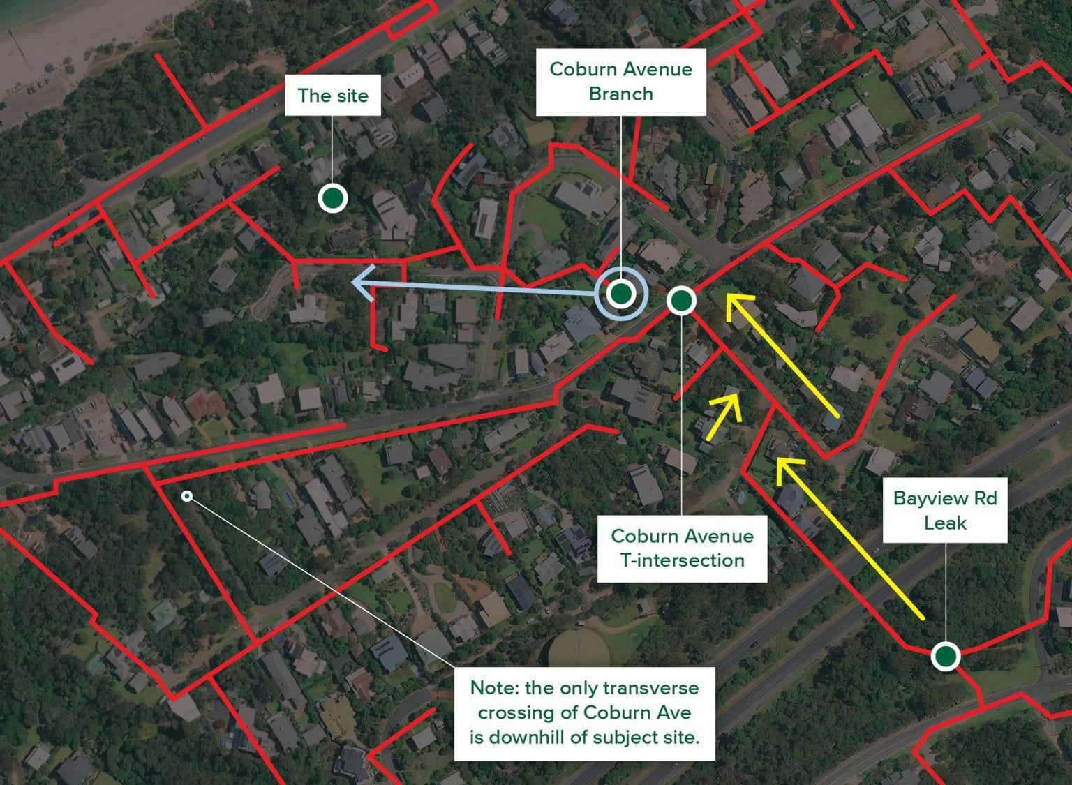
- As can be seen from the above, there is a constant run of sewer mains between the burst site and the corner of Charlesworth Street and Coburn Avenue (Coburn Avenue T-Intersection).
- A new branch of another sewer (between 31 and 31A Coburn Avenue, circled in blue (Coburn Avenue Branch) picks up across Coburn Avenue and then runs from under the homes directly opposite the Coburn Avenue T-Intersection downhill to View Point Road (blue arrow). The distance between the Coburn Avenue Branch and the sewer main that runs down Coburn Avenue is approximately 10 metres.160
- From the Coburn Avenue Branch, the sewer runs down to Prospect Hill Road, and then runs down View Point Road past numbers 6 and 10–12. Those properties are at the end of the blue arrow.
- The sewer main alone does not, however, show a complete picture of the subterranean connectivity between the burst site and View Point Road. Also present is the mains water network. Relevantly, that network runs in line with the length of Coburn Avenue, Prospect Hill Road and View Point Road. This can be observed in the following diagram:
FIGURE 4.16: WATER MAINS NETWORK.161
FIGURE 4.16

- All of that demonstrates that water mains run directly from the Coburn Avenue T-Intersection down to View Point Road.
- There is only a relatively small distance of unconnected mains between the Coburn Avenue T-Intersection (where the sewer main diverts) and the Coburn Avenue Branch (which also runs down View Point Road).
- Put another way, mains or sewer infrastructure effectively runs the entire way from the burst site to View Point Road, with one gap across Coburn Avenue for sewer only.
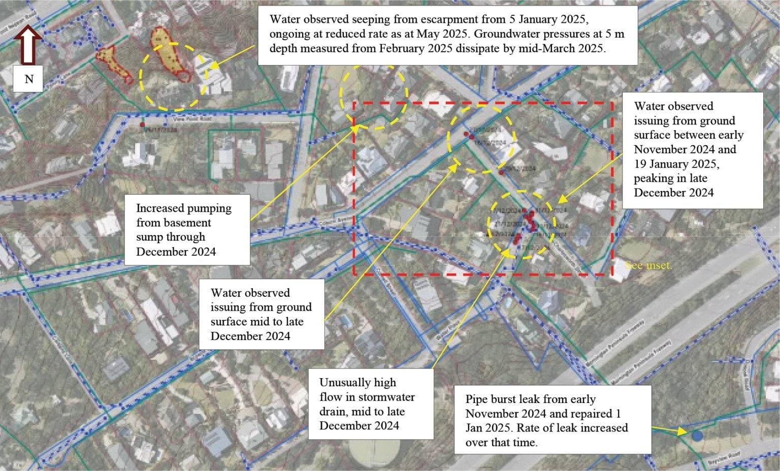
Could water have travelled from the sewer and mains infrastructure on View Point Road to the landslide site?
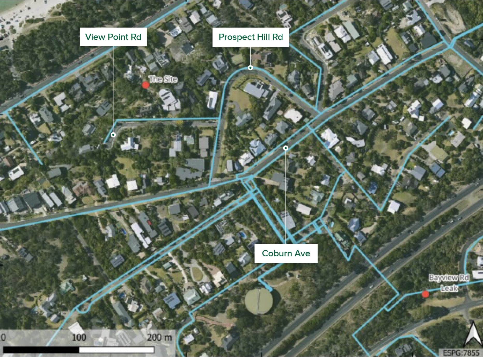
- Focussing then on the infrastructure on View Point Road, the following annotated map shows the water main, sewer and stormwater networks or systems in proximity to the top of the slope’s east gully.
FIGURE 4.17: WATER INFRASTRUCTURE IN THE VICINITY OF THE MCCRAE LANDSLIDE SITE.162
FIGURE 4.17
- As can be seen from the annotations, all three run down the northern side of View Point Road, with the sewer and stormwater systems being under the nature strip. It is approximately 25 to 30 metres from the sewer and water mains on View Point Road to the headscarp. It follows that the water that managed to reach the Coburn Avenue Branch would have had a direct path through the sewer embedment materials to within 25 to 30 metres of the landslide site.
- Bringing the above analysis of service trench connectivity together to analyse the extent of connectedness of the sewer and water mains running down View Point Road to the burst water main, it is apparent that:
- the burst occurred in a water main, with the adjacent sewer main located within 1.5 metres of the burst site;
- from there, both systems run directly to the Coburn Avenue T-Intersection (sewer main on the south-side, and water main crossing to the north);
- approximately 10 metres away, the sewer main picks up again at the Coburn Avenue Branch which runs down to View Point Road, and the water mains run around Prospect Hill Road and Coburn Avenue down to View Point Road; and
- there is approximately 25 to 30 metres from the View Point Road service trenches to the headscarp.
- In total, therefore, service trenches run for a significant proportion of the service trench flow path between the burst water main and 10–12 View Point Road.
Colluvium flow path (shallow aquifer)
- Turning then to the colluvium flow path, which describes the flow of water from the burst site towards the site of the January 2025 landslides through natural soils and the shallow aquifer.
- Mr Paul depicted that path as follows:
FIGURE 4.18: MR PAUL’S DEPICTION OF THE COLLUVIUM FLOW PATH.163
FIGURE 4.18
- As the regional cross section model extracted above shows,164 the weathered granite is overlayed by a layer of colluvium. This is also visible in Figure 8.19 from Mr Paul’s report reproduced earlier in this Chapter, as Figure 4.11, with the colluvium, which is coloured green and labelled, “Transported soils”.
- Mr Hartley explained the interaction of the colluvial layer with the shallow aquifer as follows:165
Prior to the landslide, the preferred path for groundwater was at or above the interface between the shallow aquifer and clay/bedrock until it reached the crest of the escarpment, where it permeated into the soil material covering the slope (colluvium). This colluvium forms a thin layer of soil over the underlying granite bedrock over a large area in which groundwater can permeate and disperse over an area of ground.
- The relative impermeability of the granite under the colluvium causes water that infiltrates from the surface to stop traveling vertically downward, and to instead start travelling downhill laterally along the boundary between the materials (in the “shallow aquifer”).166
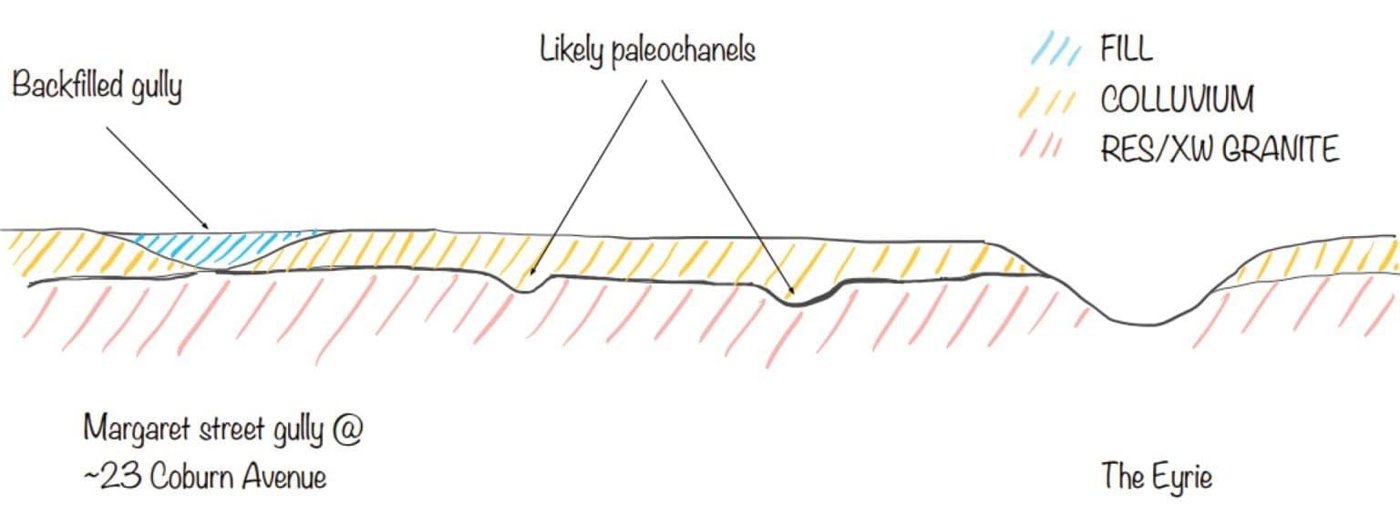
- Within that colluvial layer, changes in topography create preferential pathways for water in the form of “paleochanels”. These are areas which are relatively lower than the surrounding colluvium, as depicted by Mr Pope in the following section diagram, with the section running across the slope looking downhill:
FIGURE 4.19: CROSS SECTION OF THE GULLY AT MARGARET STREET.167
FIGURE 4.19
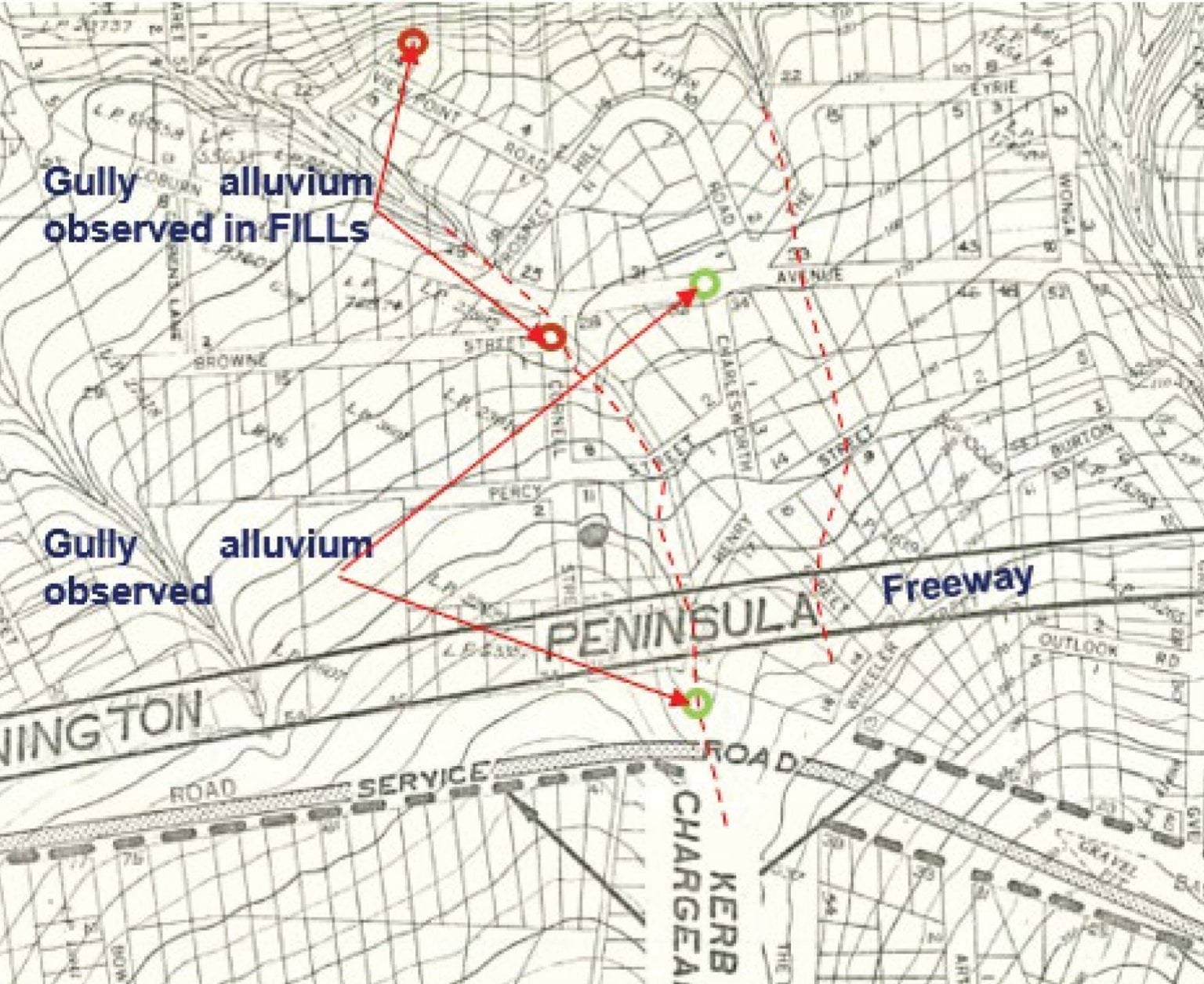
- Mr Pope’s interpretation of the natural channels that follow the topography from the Boulevard Reserve on Bayview Road down to the gully formerly running to the north of Coburn Avenue, are graphically represented at Inset 41 of his report (reproduced as Figure 4.20 below). The topographical lines on this figure show how there are natural low spots forming gullies. The left hand red dotted line is the Margaret Street Gully as labelled in Figure 4.19 above, and the right hand red dotted line is The Eyrie.
FIGURE 4.20: TOPOGRAPHICAL MAP OF THE MCCRAE AREA.168
FIGURE 4.20
- There is significant evidence of colluvium and paleochannels at various locations between the headscarp and the burst site. Mr Pope explains that borehole log reports of the Dromana Sewer Tunnel indicate that “Ligniteous Clays and Silts” were buried by surficial soils at approximately 4.3 metres from surface level, which in his opinion is direct evidence of buried paleochannels.169 More recent borehole testing has shown similar results.170
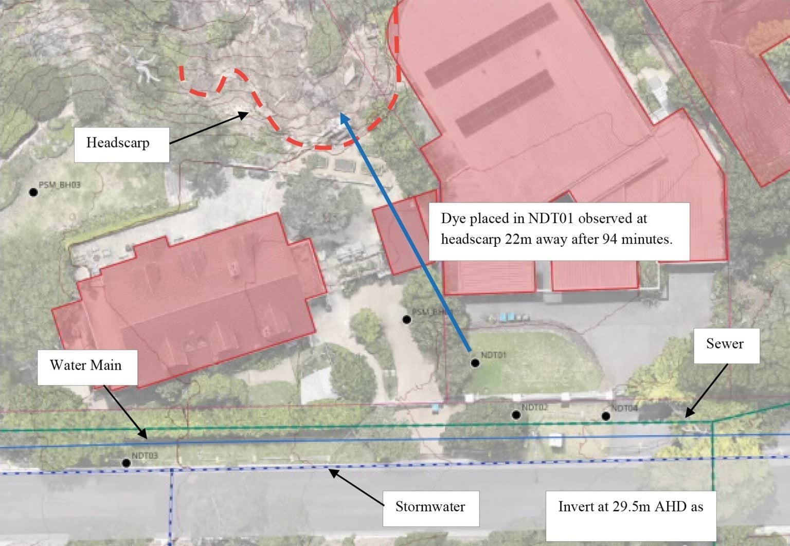
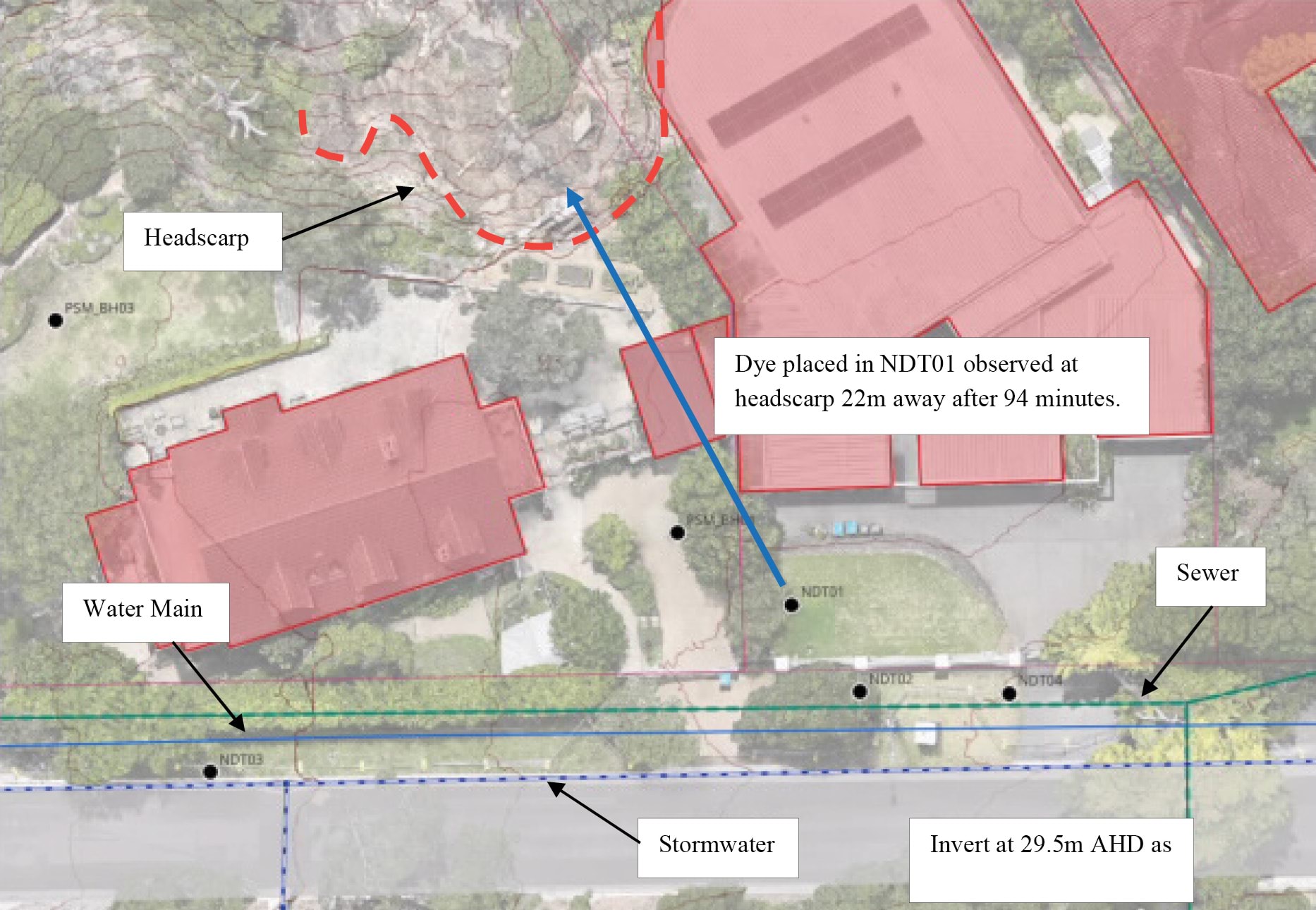
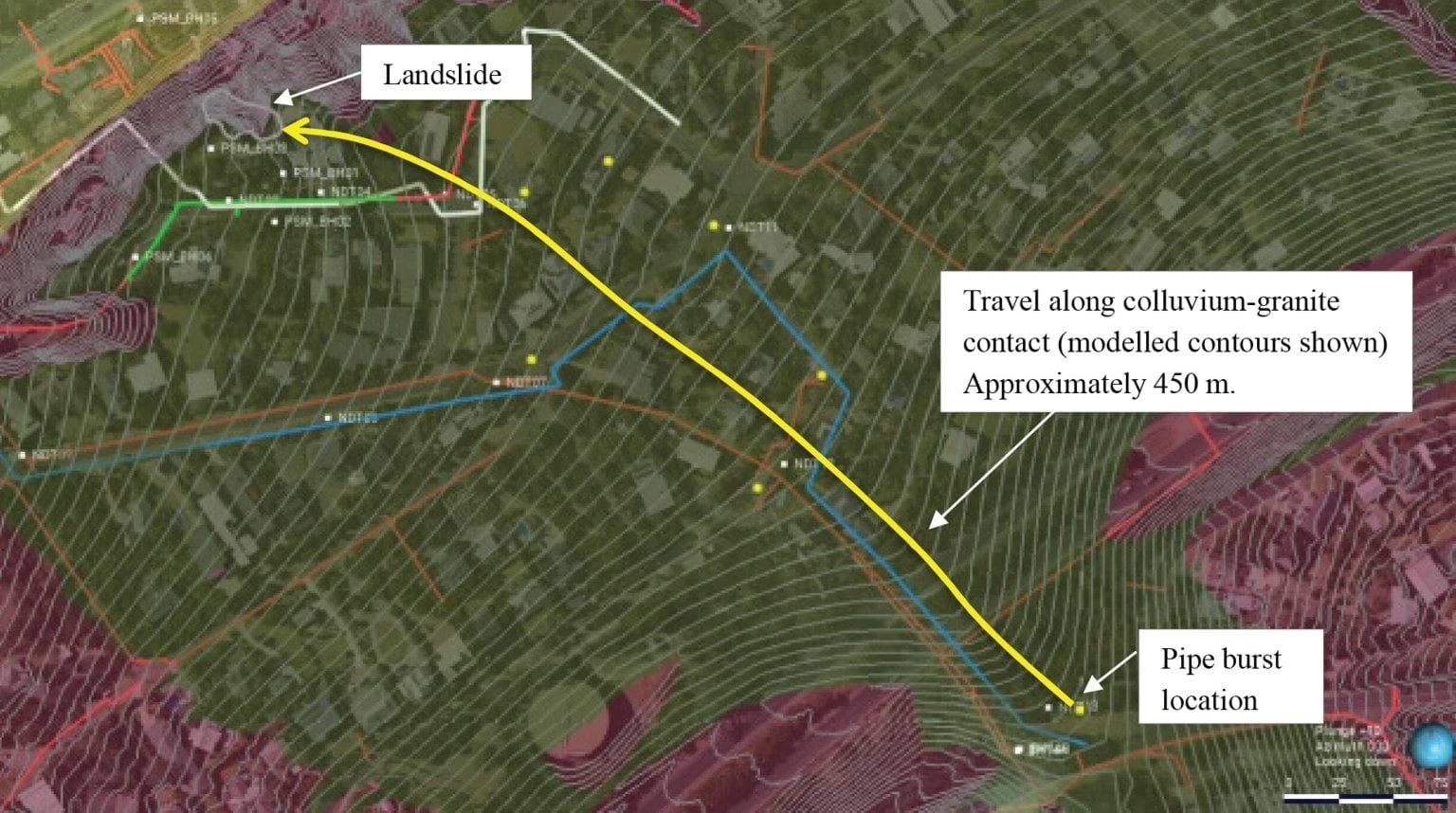
- Photographs taken by Mr Pope identify the colluvium layer at the bottom of the eastern gully at 10–12 View Point Road.171 That water flowed from the colluvium layer after the 5 January 2025 landslide evidences connectivity of that site to the shallow aquifer.172
- Mr Pope concludes, based on the evidence, that there are buried paleochannels within the colluvial layer, which vary in width between 10 and 20 metres, and which are approximately one metre in depth.173 He estimates that it would take approximately 5.4 million litres of water to saturate those channels.174
Stormwater flow path
- Turning to the last potential flow path – the stormwater flow path – which describes the flow of water from the burst site towards the site of the January 2025 landslides via the stormwater system and any breaches or defects within it.
- Mr Paul depicted that path as follows:
FIGURE 4.21: MR PAUL’S DEPICTION OF THE STORMWATER FLOW PATH.175
FIGURE 4.21
- The yellow line running from the burst water main to the left of the image is the 600 millimetre concrete stormwater pipe along which the burst water would have flowed after fanning around from the Vertical Burst Channel and running downslope into the stormwater drain. As can be seen, that pipe runs down to Coburn Avenue near the corner of Prospect Hill Road, then follows Coburn Avenue down toward the beach.
- Mr Paul hypothesised that water may have escaped through breaches or defects in the stormwater pipes, recharging the shallow aquifer and potentially reaching the landslide site.176
- There is evidence of breaches in the 600 millimetre stormwater pipe.177 Closed-circuit television cameras were fed through the stormwater pipe to inspect the condition of the pipe.178 Various defects were identified, ranging from holes to displaced joints through which soil and voids were visible.
- Mr Pope provided an annotated map showing the locations of these defects indicated by numbers one through to seven, a portion of which is extracted and annotated with arrows and comments below:
FIGURE 4.22: ANNOTATED MAP DEPICTING THE LOCATIONS OF VARIOUS STORMWATER DEFECTS.179
FIGURE 4.22
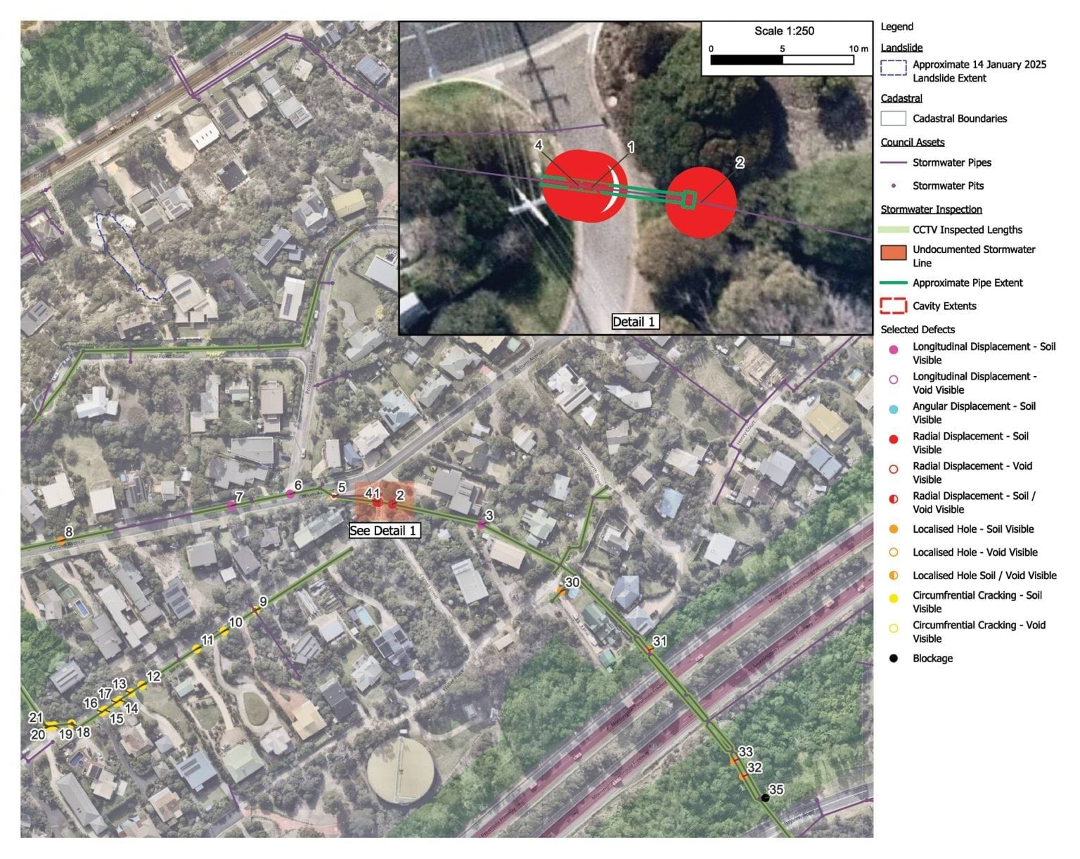
- The stormwater defects identified by Mr Pope are depicted by the numerals. Extracted below are the images of defect numbers 1 and 4 referred to at Figure 4.22, showing the extent of damage to the stormwater pipe located at Browne Street:
FIGURE 4.23: BREACHES IN THE STORMWATER PIPE LOCATED AT BROWNE STREET.180
FIGURE 4.23
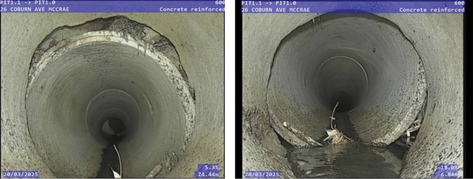
- The extent of the damage is significant. Plainly, water could, and did, exit the stormwater system through those cracks and holes in the stormwater pipe. Mr Pope estimated that the total leakage volume from the damage at the intersection of Browne Street and Coburn Avenue was in the order of 75 to 1,200 litres per day.181 In oral evidence, Mr Pope explained that he had not conducted a complete analysis of the entire stormwater channel, rather his focus was on two of the defects at the Browne Street corner.182 It follows that Mr Pope’s estimate is conservative and at least reasonably likely to underestimate the total water loss through the stormwater defects.
Where did water from the burst main, captured by the defective stormwater pipe, go?
- The experts were unable to give a definitive answer to that question. As can be seen from the annotations on the map of stormwater defects above in Figure 4.22, the majority of the defects are close to the location of the 23 Coburn Avenue burst considered in respect of the November 2022 landslides. As previously noted, Mr Paul was unable to give an opinion about the relative contribution of the 23 Coburn Avenue burst to the November 2022 landslides.183 Similarly, although the joint expert conclave report regarded the stormwater flow path to be plausible, none of Mr Paul, Mr Pope or Mr Hitchcock were able to give an opinion about whether water from the breaches in stormwater did in fact contribute to the water that triggered the January 2025 landslides.184
Did water flow through the service trench flow path, the colluvium flow path or the stormwater flow path to the site of the January 2025 landslides?
- Having described the three flow paths, it is now time to examine the evidence about the extent to which water travelled along those paths.
- There is substantial contemporaneous evidence of significant quantities of water having flowed along the three flow paths.
- The extensive evidence received by the Board of Inquiry of complaints from residents about excess water down Waller Place, Charlesworth Street, Coburn Avenue, Prospect Hill Road and View Point Road has already been set out in Part 3.5 of Chapter 3. Contemporaneous photographs and other documents put beyond doubt that excess water was present in an identifiable portion of the area between the burst water main and View Point Road, causing damage to roads and saturation of nature strips – particularly at the Coburn Avenue T-Intersection where the water would have crossed to the Coburn Avenue Branch.
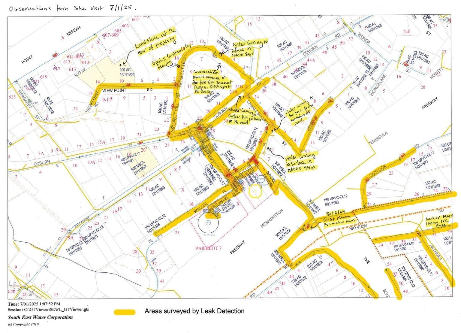
- Both the timing and location of these observations is also important. Mr Pope provided an annotated map at Figure 5 of his report showing observations made by PSM staff from site-walks on various dates between 6 January and 16 June 2025.185 Similarly, a SEW staff member, who conducted a site visit on 7 January 2025, prepared a hand-annotated map of his observations, which also track the service trench flow path. The map is shown below.
FIGURE 4.24: ANNOTATED MAP DEPICTING AREAS SURVEYED BY LEAK DETECTION.186
FIGURE 4.24
FIGURE 4.25
- Drawing from Mr Paul’s observations recorded in the Figure above, the following timeline becomes apparent:
- The first observation depicted in Figure 4.25 at the corner of Waller Place and Coburn Avenue was made at the top of the hill in around November 2024 (around the time the flow rate markedly increased).
- Water in the stormwater pipe running through Waller Place was observed flowing at an unusually high rate a few weeks later, from mid to late December 2024 (around the time the flow rate had increased further).
- The ground started upswelling at the Coburn Avenue T-Intersection at a similar time, also in mid-December 2024.
- By late December 2024, the water observed rising from the ground on the corner of Coburn Avenue and Waller Place peaked, when the flow rate from the burst water main was also peaking.
- On 5 January 2025, after the landslide, and also after the burst water main had been repaired, water was seen seeping from the escarpment in significant volumes.
- By 19 January 2025, water ceased surfacing at Waller Place and Coburn Avenue, however, down the hill, groundwater monitoring still showed groundwater which in turn dissipated by mid-March 2025.189
- Bringing the foregoing together, the observations of water surfacing downhill from the burst site chronologically match the progression of water from the burst water main, escalating in mid-October 2024, and then progressively receding after the burst water main was fixed on 1 January 2025.190
- Focusing on the landslide site itself, as has already been noted, on 6 January 2025, Mr Pope measured the flow rate from the escarpment as between 13,000 and 17,000 litres per day.191 Aside from domestic irrigation (which is considered below), there was no alternative explanation for the volume of water other than the burst water main.
- In any event, there is other evidence of hydraulic conductivity from the area around View Point Road to the escarpment. Figure 4.17 referred to earlier shows the results of a dye test conducted on 12 February 2025.192 Dye was placed by Mr Pope into a borehole labelled NDT01, located within the private sewer trench at 6 View Point Road.193 After 94 minutes, the dye appeared in the headscarp, demonstrating at least one connective path between the services infrastructure and the observed seepage in the colluvium at the headscarp.
Conclusion: water from the Bayview Road burst made it to the slope
- In summary, it is the opinion of both Mr Paul and Mr Pope that water from the burst water main did travel to the steep slope on which the 5 January 2025 landslide, and subsequently the McCrae Landslide, occurred.
- The above analysis demonstrates that:
- in excess of 40 million litres of water escaped from the burst water main;
- there were three flow paths for the escaped water;
- one of those paths (services trenches) covers a significant proportion of the distance from the burst to the escarpment; and
- water likely travelled along each of the three flow paths.
- It is the expert opinion of both Mr Paul and Mr Pope that those flow paths support a plausible hypothesis that water originating from the burst water main can account for the observations of water surfacing in McCrae throughout November and December 2024, and the water flowing from the headscarp at the site of the January 2025 landslides.
- SEW’s experts, Mr Hartley and Mr Bolton, disagreed. Though they agreed that water from SEW’s burst water main reached as far as 7 Prospect Hill Road,194 they did not consider it likely that water from the burst main contributed to the January 2025 landslides. They relied on four matters to support their view about the causal contribution of the burst water main to the landslides as insignificant to minor:
- first, most of the water would have flowed into the stormwater system;
- second, the velocities at which water would have travelled along the flow paths to the headscarp meant the water would not have reached the headscarp even by 5 January 2025;
- third, chemical testing of water from the headscarp indicated that it was not mains water; and
- fourth, given the small volume of water estimated to be required to cause the 5 January 2025 landslide, there are other plausible sources of water.195
- Each of those matters is now considered. As the only alternative source of water identified by Mr Hartley and Mr Bolton was domestic irrigation, it is convenient to defer consideration of that final matter until domestic irrigation is considered more generally.
The basis for SEW’s position that the burst water main did not cause the McCrae Landslide
Stormwater system
- As has already been identified, there were breaches in the Shire’s stormwater system through which water would inevitably have exited. The full extent of those breaches would only become apparent if a full video inspection was conducted of all relevant stormwater pipes. But it is beyond doubt that even on the more limited inspection undertaken, there were sizable ruptures in the pipes.
- While the exact volume of water that discharged through those breaches is unknown, it is probable that such outflows contributed to recharging the shallow aquifer.
- Whether water travelled through the shallow aquifer to the headscarp at 10–12 View Point Road is a different question. The Board of Inquiry has already considered the potential contribution of the 23 Coburn Avenue burst to the November 2022 landslides. The limitations identified there apply equally here and limit the confidence with which any conclusion about the contribution of stormwater leakages to the January 2025 landslides can be drawn.
- It is certainly possible that water from the burst that exited through breaches in the stormwater system recharged the shallow aquifer, reaching the headscarp. The Board of Inquiry does not accept Mr Hartley’s and Mr Bolton’s view that the fact that most of the water discharging from the burst main travelled through the stormwater systems establishes that none of that water entered the headscarp.
Velocity
- Mr Hartley and Mr Bolton also relied on water velocity as invalidating the hypothesis that water from the burst water main contributed to the January 2025 landslides. Mr Hartley and Mr Bolton’s opinion was that it would take 230 days for water travelling through the colluvium to reach the headscarp.196 That being so, as the burst began in August 2024, around 157 days prior to 5 January 2025, they did not consider that water from the burst could have reached the headscarp.197 This 230-day figure was explained to be based on a rough, but conservative, estimated average transmission speed of two metres per day.198
- Mr Hartley and Mr Bolton’s estimate rested on a large assumption: that water travelled exclusively through the colluvium,199 which stands or falls depending on its reasonableness.
- Mr Makin was the first expert to expose a flaw in the assumption. He used the same underlying equation as Mr Hartley and Mr Bolton,200 but provided alternative assumptions about the soil composition. His analysis demonstrated that, if the material consisted entirely of sand, the estimated travel time from Bayview Road to the headscarp would be 1465 days, whereas if the path was entirely consisted of gravel, the travel time would reduce to only 12 days.201 This analysis highlights how sensitive the velocity calculation is to assumptions about the soil composition.
- Next, Mr Hitchcock emphasised the inherent variability of assumptions about soil composition in his explanation during the public hearings.202 In his view, the 230-day figure was in “the same ballpark” as 150 days.203 That is, the inherent variability of soil types and the effect on velocity meant that any estimate was unlikely to be sufficiently precise to rule the burst water main in, or out, as a water source.
- Even assuming the accuracy of Mr Hartley and Mr Bolton’s assessment of the velocity of two metres per day through the colluvium, if the total non-trench flow travel distance from the burst water main to the landslide site is only about 40 metres, that part of the water’s journey to the headscarp would take about 20 days. This was in substance accepted by Mr Hartley in examination, where he stated:204
If you’re going through natural material – if you’re going through natural material, based on [Mr Bolton’s] site works and computations, no. If you’re going through … an entire manmade trenched pathway you’re going to get there earlier. And if you’re going through … the preferred line of going through the trenches, getting to Coburn Avenue, sitting there because the velocity goes to zip and going through the natural material underneath the houses, including number 5 Prospect Hill, getting into the agi-drains or the sewer trench situation of 7 Prospect Hill Road, and then going down there, you’re looking in the region of about 30 days. And so, yes, it could get there on the 5th, but if it’s going to get there on the 5th it’s going to get there beforehand.
- Relatedly, Mr Hartley accepted in oral evidence that the flow time from the sewer T-junction at the corner of Coburn Avenue and Charlesworth Street and the sewer between 31 and 31A Coburn Avenue (as explained earlier) would take approximately five days.205
- The fundamental flaw in SEW relying on the 230-day estimate to try to invalidate the hypothesis that water from the burst water main contributed to the January 2025 landslides is that it assumes water travelled exclusively through the shallow aquifer.206 If that assumption is falsified, that is, if water could have reached the headscarp through the shallow aquifer and the service trenches, then the estimate is unreliable.
- No expert considered a travel path of colluvium alone to be realistic. Mr Pope referred to the “blatant disconnect” between the 230-day estimate and the surface water observations in the community.207 The Board of Inquiry agrees with that obvious disconnect.
- SEW subsequently provided further information about velocity modelling. That material does not alter the above conclusions. All of the experts accept that water from the burst main made it to at least Prospect Hill Road, as reflected in saturated nature strips and water bubbling up through the roads.208 From there it had tens of metres more before it hit further sewer trenches taking it to the headscarp. Even with very low velocity, the water could have made it in time to trigger the 5 January 2025 landslide.
- The Board of Inquiry accepts the opinions of Mr Paul, Mr Makin, Mr Pope and Mr Hitchcock on this issue. SEW’s velocity argument is untenable – it artificially assumes that water would flow through one flow path to the exclusion of the others. Even if the Board of Inquiry were to assume, for the sake of analysis, that water travelled exclusively through colluvium, it still does not follow that the journey from the burst site to the headscarp would have taken 230 days. The colluvium consists of a heterogeneous mix of soils, which, in turn, introduces variability in flow velocity. Because the precise composition of the colluvium flow path is unknown, any estimate of velocity is inherently imprecise. Accordingly, the 230-day figure, even on Mr Hartley and Mr Bolton’s theory, is neither fixed nor reliable.
Water chemistry
- Next, SEW’s experts, Mr Hartley and Mr Bolton, relied on the chemical analysis of water samples taken both before and after the January 2025 landslides to support their view that water from the burst water main had not triggered the landslides.
- Water samples were taken from various locations, including the landslide site itself, upwelling within potholes on Charlesworth Street and surrounds, from stormwater drains, and from groundwater in boreholes. Annexure E to the SMEC report shows testing locations for the majority of those tests.209
- Of those samples, only two were taken of the water seeping from the escarpment in the days after the January 2025 landslides (Seepage Samples). The main questions in dispute between the hydrochemist and hydrogeologists were:
- whether the electrical conductivity and chloride of the Seepage Samples could have been achieved by a mixing of mains and groundwater; and
- whether the tested electrical conductivity and chloride levels was a consequence of the water’s path of travel through the geological structures between the burst water main and the headscarp.210
- In Mr Hartley and Mr Bolton’s view, the answers to those two questions are “no”. They opined that the electrical conductivity (or salinity) of the Seepage Samples taken between 6 January and late January 2025 were too high to be mains water.211 Moreover, they opined that the chemistry of the Seepage Samples did not indicate a dilution of mains water with groundwater from the shallow aquifer.212 It followed, in their view, that the water in the Seepage Samples had not originated from the burst water main.
- While Mr Hartley and Mr Bolton accepted that a portion of water from the burst site migrated toward 7 Prospect Hill Road via Waller Place, Charlesworth Street, and the intersection of Charlesworth Street and Coburn Avenue,213 they concluded that the water did not progress toward the escarpment on which the January 2025 landslides occurred.
- The reasoning underpinning that conclusion requires some explanation. It turned on an analysis of the chemical properties of water tested both before and after the burst water main was repaired from two potholes: the Waller Place/Charlesworth Street pothole and the Coburn Avenue/Charlesworth Street pothole. The short point is that both the salinity and chloride levels of water in those potholes jumped up after the burst water main was repaired.
- What was the significance of this jump? Mr Bolton thought it spoke to the extent to which the water travelled.
- Mr Bolton’s theory was that water from the burst entered the permeable embedment material and then travelled to the Waller Place/Charlesworth Street pothole site (Column A in the graphs below). Testing in December 2024 and early January 2025 showed that water in that pothole initially had a lower electrical conductivity level, which is more consistent with mains water.214 Then, after the burst main was repaired, “the [electrical conductivity] level jumps back up again”, which, on Mr Bolton’s theory, indicated that the mains water had stopped reaching that location and diluting the groundwater.215 Mr Bolton gave similar evidence in relation to the Coburn Avenue/Charlesworth Street pothole (Column B in the graphs below).216
- The water testing results for electrical conductivity and chloride levels for those potholes, as well as water collected at 7 Prospect Hill Road and the landslide site, are depicted in the graphs below:
FIGURE 4.26: GRAPHS DEPICTING THE ELECTRICAL CONDUCTIVITY AND CHLORIDE CONCENTRATION IN WATER SAMPLES.217
FIGURE 4.26
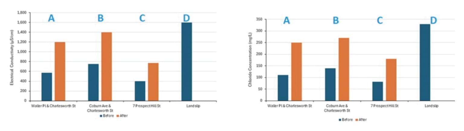
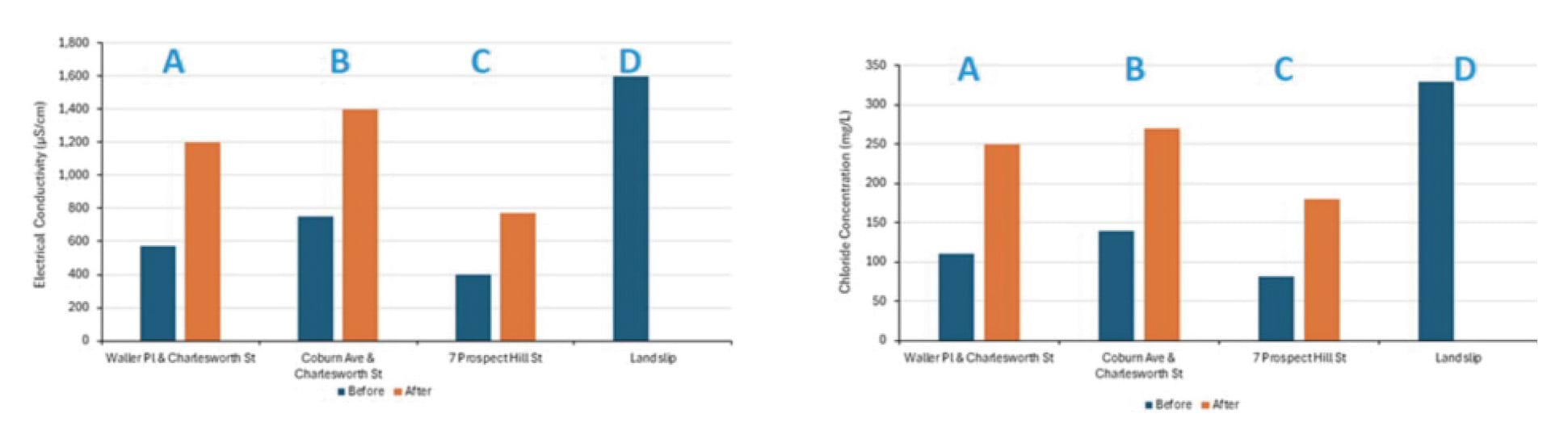
- The Board of Inquiry does not accept Mr Bolton’s theory. It draws unsteady distinctions. It considers only a limited selection of water samples. On closer examination, it does not withstand scrutiny.
- First, Mr Bolton’s theory attributes entirely opposite interpretations to similar electrical conductivity and chloride levels. On the one hand, his theory accepts that the water sampled on 16 January 2025 from the Waller Place/Charlesworth Street pothole – which had an electrical conductivity of 1200 MicroSiemens per centimetre and chloride concentration of 250 milligrams per litre – was connected to the burst water main. On the other hand, his theory rejects that the Seepage Sample taken on 6 January 2025 – which had an electrical conductivity of 1,600 MicroSiemens per centimetre and chloride concentration of 330 milligrams per litre – was connected to the burst water main.218 During examination, the tension between these interpretations was exposed. Mr Bolton accepted that the electrical conductivity and chloride figures were “similar” for those water samples.219 He conceded that based on those similar readings, it was open to conclude that the water seeping from the escarpment was also connected to the burst water main.220
- Second, Mr Bolton’s theory does not apply consistently across all the water samples taken. For example, water sampled on 22 January 2025 from the Coburn Avenue/Waller Place pothole had an electrical conductivity of 1000 MicroSiemens per centimetre, when, on the same day, water sampled uphill of that location at the “verge opposite 5 Waller Place” had an electrical conductivity of 600 MicroSiemens per centimetre.221 If Mr Bolton’s theory was correct, the electrical conductivity should have been higher uphill as that area had returned to groundwater levels of electrical conductivity and chloride following the repair of the water main. Mr Bolton could not explain this inconsistency – he accepted the results did not sit well with his theory.222
- It follows that even on his own evidence, Mr Bolton’s theory does not fit all of the data. Without a robust justification for the inclusion and exclusion of the other samples, the theory is also incomplete. It does not invalidate the hypothesis that water from the burst water main reached the headscarp.
- Third, there are plausible alternative explanations, beyond Mr Bolton’s theory, for the elevated levels of electrical conductivity and chloride in the water samples taken after the repair of the burst water main. An expert engaged by the Board of Inquiry, Dr Vu, explained that the higher electrical conductivity readings in those later samples could be a product of either the water spending a longer time travelling, and therefore dissolving more salts, or the water travelling through a different, less permeable, pathway on which it picked up more ions.223
- In view of the above, Mr Bolton’s theory does not preclude the possibility of water from the burst reaching the escarpment. Having rejected his theory, it is now necessary to consider the views of the other experts in relation to the Seepage Samples taken from the escarpment.
- Mr Hitchcock and Dr Vu considered that the Seepage Samples were potentially a combination of mains water and groundwater, and that there was a plausible flow path from the burst water main to the headscarp (i.e., that the chemical composition of the Seepage Samples did not rule out that they were partly derived from mains water).224
- Similarly, an expert engaged by SEW, Mr Jewell, concluded with a high degree of confidence that the water emanating from the headscarp after the 5 January 2025 landslide was comprised of a mixture of mains water and groundwater.225
- Under cross-examination, Mr Hartley accepted that his conclusion that the burst water main was not the source of water in the slope hinged on questions of velocity and water chemistry.226 As to velocity, the conclusion, as already explained, is founded on unrealistic assumptions. As to water chemistry, Mr Hartley appeared to concede that the likelihood that water from the burst was not present in the slope was “low”.227
- After the experts gave concurrent evidence at the hearings, SEW produced an expert report prepared by Mr Jewell dated 8 August 2025.228 Mr Jewell opined that it is “unlikely” that the water flow at the escarpment originated from the burst water main having regard to, among other things, the geochemical nature of the water.229 That is, while he accepts that mains water was seeping out of the headscarp, he does not accept the origin of that water to be the burst. Mr Hitchcock, Mr Pope and Mr Paul confirmed that Mr Jewell’s report did not cause them to change their opinions.230
- The Board of Inquiry does not accept that Mr Jewell’s revised analysis disproves that the Seepage Samples were derived substantially from water from the burst. His analysis is defective.
- Notably, in assessing the geochemical nature of the water, Mr Jewell used a chloride concentration for deep groundwater (480 milligrams per litre),231 which is not representative of the interface groundwater but that of deeper aquifer groundwater.232 This assumption is critical, as the imputed groundwater/mains water ratio depends directly on the assumed chloride level in groundwater. In this regard, the Shire stated:
Both Mr Hitchcock and Mr Paul opined that a more appropriate chloride concentration of groundwater for the water balance analysis is between 100 mg/L and 170 mg/L as observed in SMEC BH03 and BH04, being representative of interface groundwater. If this concentration is adopted (even assuming other aspects of Mr Jewell’s approach are sound), it has a material impact, [on the analysis]).233
Domestic irrigation as a source
- The first three bases relied on by Mr Hartley to found his opinion that the burst water main did not contribute to the January 2025 landslides have now been considered and dismissed as not invalidating that causal hypothesis. The final matter pointed to by Mr Hartley and Mr Bolton in support of their contention that the burst main was not the source was an alternative hypothesis that domestic irrigation was the or a source.
- This thesis hinged largely on a hypothesis that only 2,000 litres of water was required to enter the headscarp in order for a landslide to occur. That is, the volume of water required to trigger the 5 January 2025 landslide was so small that other sources of water could be plausible triggers.234 The only alternative source of water identified by Mr Hartley was domestic irrigation, and it was asserted that this was a possible source of the seepage flow visible after the 5 January 2025 landslide.235
- This theory depends upon two matters:
- whether the volume of water required to trigger the 5 January 2025 landslide is indeed only 2,000 litres; and
- whether it is plausible that domestic irrigation could explain a substantial part of the seepage seen after the 5 January 2025 landslide.
- Both matters can be dealt with in short order.
- The suggestion that only 2,000 litres of water was required to cause the 5 January 2025 landslide is untenable. The following matters are referred to:
- The video taken of the moment the McCrae Landslide occurred shows the soil pouring downhill as a liquid.236 Approximately 300 cubic metres was evacuated in this debris flow. Evidently a great amount more than 2,000 litres was contained in that soil.237 It is unexplained how such an amount of water could have built up to cause the McCrae Landslide debris flow while only 2,000 litres was apparently required to trigger the 5 January 2025 landslide only nine days prior.
- The area which suffered the landslides in 2025 did not fail during the significant 80 millimeter rain event in November 2022. If so little water could trigger the January 2025 landslides as is now asserted by SEW, the fact that the area did not fail after the historic rainfall in 2022 would need to be explained. No convincing explanation was given. As Mr Pope said, the 2,000 litre theory is not calibrated against historic slope performance.238 Mr Hartley accepted (1) that he had not undertaken analysis to compare how the slope could have withstood the rain in 2022 despite his estimated 2,000 litre trigger volume;239 and (2) that he did not take the 2022 rain event into account to test his model.240
- The flow rate of water measured seeping from the headscarp on 6 January 2025 by Mr Pope was between 13,000 and 17,000 litres per day.241 If the headscarp was so vulnerable to landslide from only 2,000 litres, it would have failed much earlier.
- The significant and continued flow rate from the headscarp post 5 January 2025 cannot possibly be accounted for by domestic irrigation alone.
- Mr Makin provided an analysis of the volume of water required to trigger the McCrae Landslide. He estimated that approximately 36,000 litres of water would be required to trigger the 300 cubic metres of material that evacuated during the McCrae Landslide.242 During examination by Counsel for SEW, Mr Hartley explained that his estimate of 2,000 to 2,300 litres to trigger the 5 January 2025 landslide was roughly equivalent to the figure given by Mr Makin, when the relative volumes of the landslides (20 cubic metres and 300 cubic metres) were taken into account.243 The Board of Inquiry does not accept Mr Hartley’s analysis.
- Mr Paul’s failure mechanism theory is that water infiltrated via the colluvium between 5 and 14 January 2025, saturating the surrounding soil and then further spreading outwards. It is not a matter of simply dividing the volume of soil that was displaced, but of understanding how increasing water flow through that soil from the colluvium progressively filled pores until failure. Mr Paul explained that the equivalent to this “would be like getting a bowl of flour and putting a thimble of water in it and expecting it to turn into batter”.244
- Ultimately, during cross-examination, Mr Hartley accepted that it was “fair” to describe this theory as “speculation about a possible alternative”.245 The Board of Inquiry does not accept the 2,000 litre thesis. At a minimum, it is contrary to the observed facts. Even accepting that it is theoretically possible domestic irrigation contributed to the observed water from the headscarp after 5 January 2025, this analysis still does not explain the source of the significant volume of water exiting for a lengthy period thereafter, nor what happened to the water that was accepted by SEW’s experts to have reached at least 7 Prospect Hill Road. Moreover, if so little water was required, and domestic irrigation was a plausible source, it would have been necessary to explain how the level of irrigation had varied over time so as to identify why the slope failed in 2025 and not before.
- SEW’s 2,000 litre theory is speculative and does not create any doubt that the January 2025 landslides were caused by the burst water main.
Conclusion – the burst water main caused the McCrae Landslide
- In summary, from early August 2024 to 1 January 2025, SEW’s burst water main caused approximately 40.3 million litres of water to be discharged. A large portion of that water was captured by the stormwater system, with the balance travelling downhill through colluvium and in service trenches. In a temporally staggered way, that water flowed downhill, breaking through roads, saturating kerbs, and causing sump pumps to run. All experts agreed that water from the burst water main reached at least Prospect Hill Road, within less than 100 metres of the landslide site.
- After the 5 January 2025 landslide, a significant volume of water continually flowed from the headscarp down the slope. This was also not disputed.
- The Shire submitted that the water main burst should be found to be the cause of the January 2025 landslides.246 SEW submitted “there is no empirical evidence that proves the Bayview Burst triggered the landslide.”247 Its submissions point to the various inferences drawn by the experts in forming their conclusions, the lack of certain geophysical tests undertaken, and the slight inconsistencies between other tests.248
- The Board of Inquiry considers there is simply no plausible hypothesis that explains the water progressing down the slope, the landslide, then the significant water continuing to flow from the headscarp other than the burst water main at Bayview Road. There were multiple available flow paths for the water to travel along. Neither water chemistry nor theories as to water velocity cast doubt on the ability of water to travel via one or more of those paths to reach the slope in sufficient time to saturate it before the 5 January 2025 landslide.
Water was the trigger of the 5 January 2025 landslide and the McCrae Landslide. The source of that water was the burst water main at Bayview Road.
Finding
Water from the burst water main owned by SEW caused the 5 January 2025 landslide and the McCrae Landslide.
Delays in detecting the burst water main
- The Shire’s submissions urge the Board of Inquiry to make a finding that SEW’s delay in locating the burst water main was itself a cause of the McCrae Landslide. They state (omitting footnotes):
Delay of South East Water in detecting the burst water main: If the Board accepts, as the Shire submits, that the Bayview Leak was the cause or trigger of the McCrae Landslide, it follows that SEW’s failure to detect the burst for (according to expert evidence) over 150 days, despite numerous reports made to SEW of upwelling from at least late November 2024, contributed to the McCrae Landslide. Had SEW adequately responded to the concerns of residents and detected the Bayview Leak earlier, less water would have been lost from it, and less water would have travelled to the landslide site.249
- While the Board of Inquiry has found that water from the burst water main was the cause of the trigger of the January 2025 landslides, it does not follow that the Board of Inquiry can make a finding about whether delay in identification of the burst was also causal. Such a finding would depend upon further evidence and analysis of counterfactuals. The evidence does not establish the critical threshold or timing at which intervention would have averted the landslides.
4.6 What were the preparatory factors that contributed to the 5 January 2025 landslide and the McCrae Landslide?
- The next area of focus is preparatory factors. There was some disagreement between the experts as to the contribution of preparatory factors, including erosion, the impact of fill on the escarpment, and the retaining walls in the east gully on 10–12 View Point Road, to the January 2025 landslides.
- Each of these preparatory factors is addressed in turn below.
Erosion of the escarpment
- All experts agreed, with a very high level of confidence, that erosion was a significant preparatory factor for the 5 January 2025 landslide.250 They did not consider erosion as a preparatory factor for the McCrae Landslide, but they did express views on its contribution as a cause of the McCrae Landslide.
- Mr Paul considered the contribution of erosion as a triggering factor for the McCrae Landslide to be minor.251 He considered the continued infiltration of water into the headscarp from the burst water main to be the significant trigger. While Mr Pope agreed that the water was a trigger, he also considered erosion caused by the 5 January 2025 landslide to have a significant contribution to the McCrae Landslide.252
- Mr Pope was of the view that the loss of material following the 5 January 2025 landslide destabilised the “slopes at the eastern extent of the gully where there was significant filling and no effective retaining wall”. He described this as “regression by landsliding”.253
- Mr Hartley considered:
[T]he removal of soil [consequent to] the 5 January 2025 [landslide] to be significant in destabilising the gully to the extent where the ravelling back of material between 5 January and 13 January, and [the McCrae Landslide on] 14 January were a direct consequence of the 5 January event.254
- There is no doubt that the continued infiltration of water from the burst water main was, at the very least, a major trigger of the McCrae Landslide. To the extent that it matters, the Board of Inquiry considers it probable that erosion caused by the 5 January 2025 landslide had some destabilising effect on the headscarp and aided the subsequent McCrae Landslide.
The impact of fill
- The experts disagreed about the effect of fill, in particular “old” fill, as a preparatory factor for the January 2025 landslides. Mr Pope described “old” fill as fill that was likely end dumped over the escarpment no later than the 1970s.255
- Mr Paul’s view, expressed with a moderate degree of confidence, was that old fill was a minor contributing factor to the instability of the escarpment, whereas Mr Pope considered, with high confidence, that it was a major contributing factor.256 Mr Hartley’s view was in between the two opinions. He considered old fill to be a medium contributing factor to the instability of the escarpment, and expressed that view with a moderate degree of confidence.257
Mr Paul’s assessment of fill
- On Mr Paul’s analysis of the data available to him, the presence of fill on the escarpment was of little to no consequence to the cause of the 5 January 2025 landslide and the McCrae Landslide.
- Mr Paul explained that:
- Normally, water flows through the colluvium and is discharged at a spring, along the escarpment.258 The finer soils above the colluvial channels are ordinarily dry, and their cohesion is a consequence of high soil suction, otherwise known as negative pore water pressure.259
- As a result of the burst water main, the increased volume of water travelling through the colluvium meant the natural ability for the water to emanate from the spring was overwhelmed.260 This forced the water to travel up into the finer soils, causing those soils to become saturated and ultimately, to slide.261
- Mr Paul considered that the escarpment included some fill, because fill was exposed in the headscarp following the landslides in January 2025. He could not dismiss the possibility that the displaced material was at least partially comprised of fill, but stated that he had not seen any physical evidence to indicate that a large volume of fill was placed on the escarpment. Rather, he noted that most of the exposed headscarp and side scarps were comprised of natural materials.262
- In any case, Mr Paul concluded that:
… because of progressive wetting of fine grained soils (fill or natural) the landslides of 5 January and 14 January 2025 would have occurred irrespective of whether the soils that became wet were natural or fill materials.263 (emphasis added)
Mr Pope’s assessment of fill
- Mr Pope disagreed with Mr Paul’s assessment of the volume of fill on the escarpment and the contribution of that fill as a preparatory factor for the McCrae Landslide. Based on his visual observations of the headscarp following the McCrae Landslide, he considered there to be a volume of fill at the top of the escarpment that was at least two metres deep.264 Mr Pope also considered borehole samples, LiDAR, and survey information to conclude that the gully where the McCrae Landslide occurred was asymmetrical prior to the McCrae Landslide.265 He stated:
Fundamentally the gully is out of balance when viewed in elevation cut parallel to the escarpment … i.e. it is not broadly symmetrical along the plunge of the gully line as most gullies along the escarpment are.266
- Mr Pope noted that the nearby gullies at The Eyrie, Coburn Creek, and the downstream section of Margaret Street, are not asymmetrical. Given the presence of fill at the top of the escarpment, and the unique profile of the gully where the McCrae Landslide occurred, he concluded that the explanation for the asymmetry of the gully was the presence of anthropogenic fill.267
- Mr Pope identified the LiDAR relied upon by Mr Paul was not as fulsome as the LiDAR and survey materials he had considered.268 The Board of Inquiry notes this could provide an explanation for the differences in the models generated by those experts with respect to the volume of fill on the escarpment.
- In any event, on the basis of Mr Pope’s analysis, he considered the presence of fill on the escarpment to be a “fundamental cause of the 2025 landslides”.269 He stated that:
[At] some stage in its life, [the escarpment] would be expected to fail in this manner once appropriate triggers occurred. In my opinion if the Old Fill was not placed into the gully, the 2025 Landslides [would] not [have] occur[ed].270 (emphasis added)
Mr Hartley’s assessment of fill
- Mr Hartley gave limited evidence about the presence of fill on the escarpment, though his views aligned most closely with Mr Pope’s.
- He explained that, ordinarily, he would expect water to exfiltrate from a spring in the centre of a gully, but that did not occur in the aftermath of the 5 January 2025 landslide. Rather, the water emanated to the side of the gully’s centre line. Like Mr Pope, Mr Hartley considered a plausible explanation for this to be the presence of fill on the escarpment.271 He made no further comments as to the impact of fill in respect of the McCrae Landslide.
Conclusion on whether fill was a preparatory factor for the McCrae Landslide
- Having regard to the varying views of the experts, it is apparent to the Board of Inquiry that the key matters of contention between them were the composition of the material that slid down the escarpment as a result of the January 2025 landslides, and to the extent that the material was compromised of fill, the volume of it.
- The Board of Inquiry makes no finding as to the volume of fill that may have been placed on the escarpment many decades ago. There is insufficient evidence about that matter for a finding to be made.
- The Board of Inquiry finds for the reasons given by Mr Paul, that irrespective of the volume of fill, the 5 January 2025 landslide and the McCrae Landslide would have occurred as a result of the water from the burst water main. It considers the significance of fill as a preparatory factor to the January 2025 landslides to be minor. It is possible that the unknown volume of fill contributed to the size of the McCrae Landslide but the evidence does not enable findings to be made about different counterfactual circumstances.
Retaining walls at 10–12 View Point Road
- As detailed in Chapter 3 of this Report, two retaining walls were erected on the Borghesis’ property between 2022 and 2024 in the east gully, above the site of the McCrae Landslide.
- The experts disagreed about the significance of the preparatory effect of the retaining walls. Mr Paul considered the retaining walls to be a minor (1% – <10%) contributing factor to both the 5 January 2025 landslide and the McCrae Landslide, and expressed his view with a medium degree of confidence. In contrast, Mr Pope considered the retaining walls to be a major (30% – <80%) contributing factor, with a high degree of confidence. Mr Hartley agreed with Mr Pope, that the retaining walls were a major contributing factor to the McCrae Landslide, with a high degree of confidence, and a medium contributing factor to the 5 January 2025 landslide, with a low degree of confidence.272
Mr Paul’s assessment of the retaining walls
- Mr Paul’s overall view of the contribution of the retaining walls to the 5 January 2025 landslide was that the surcharge load behind the retaining walls was significantly outweighed by the volume of water infiltrating the escarpment prior to the landslide. His view remained the same in respect of the McCrae Landslide.
- Turning first to the 5 January 2025 landslide, Mr Paul noted the location of the top of the zone of depletion was approximately two and a half metres below the base of the retaining wall. This was too far away from the zone of influence of the retaining wall (or the passive wedge), which indicated “the retaining wall could not have applied load to the soil that [was] displaced [by] the 5 January 2025 [landslide]”.273
- Further, Mr Paul observed that, instead of the soil that was being retained developing cracks or showing signs of subsistence, it was the soil in front of the retaining wall that developed cracks and showed signs of subsistence on 6 January 2025. He stated “the observed tension cracks indicate[d] soil moving away from the [toe of the] retaining wall and [were] an indicator that the 14 January 2025 landslide was developing at that time”.274 (emphasis added)
- Mr Paul concluded the retaining walls were a minor preparatory factor for the McCrae Landslide. He considered the failure of the retaining wall to be a part of the McCrae Landslide. This was on the basis that the infiltration of water into the escarpment from the burst water main which caused the landslide also undermined the retaining wall and caused it to fail.275 In contrast to Mr Pope’s view, Mr Paul did not consider the surcharge load of the soil retained by the wall to have contributed to the McCrae Landslide.276
- This Report now turns to Mr Pope’s analysis.
Mr Pope’s assessment of the retaining walls
- Mr Pope considered the retaining walls did place a surcharge load on the escarpment. He discussed this, and the consequent contribution of the retaining walls to the January 2025 landslides, having regard to elements of the design of the walls, and the use of the land retained by them.
- First, Mr Pope expressed the view that “it would be grossly unconservative to ignore the buried geometry at the retaining wall and the 40kPa surcharge especially where there is no pile socket”.277 He explained the retaining wall having been built on an incline plain, should have been piled into the granite because without that, it would not be able to overcome the driving forces of the active side of the retaining wall.278
- Second, Mr Pope identified that the retaining wall had not been tied back and did not extend across the entirety of the fill, pursuant to his model.279
- Further, in addition to these design issues, Mr Pope pointed to the loading of the area retained by the walls. He thought that, by virtue of the retaining walls’ construction, the effective slope angle of the escarpment had increased from 32 to 37 degrees.280 Together, the loading and the slope angle, had the effect of increasing the load on the active side of the retaining wall, without making any provision for any corresponding increase in the resisting forces on the passive side of the retaining wall.281
- In those circumstances, any increase in groundwater would have reduced “the effective stresses on the resisting side” of the retaining wall erected in 2024, such that the “resisting forces must also be reduced”.282 Mr Pope stated:
In my opinion, my facts on which I rely support that there have been multiple instances of increased loading associated with the [retaining wall] on multiple inclined plains immediately beneath and within influence of the [retaining wall] and with a decrease in sheer strength on the passive side of the wall due to the increase in groundwater levels.283
- In support of his view, Mr Pope referred to his observation of a significant crack beneath the retaining walls at 10–12 View Point Road on 6 January 2025. He opined that the crack was in line with the area where maximum fill had been placed behind the retaining wall, and that this placed pressure on the passive wedge causing it to crack.284 As opposed to Mr Paul, who considered the crack at the toe of the retaining wall to evidence the slope moving away from the wall, Mr Pope stated:
My view is that that’s the toe of the passive wedge failing. So it’s moved at the base of the wall. So the displacement is at the base of the wall. It’s well within the zone of influence of the wall. It’s literally under the wall.285 (emphasis added)
- Mr Pope concluded:
Analysis of the [retaining walls] and the loading on the passive wedge must consider the unfavorable influence of the inclined plains on the passive side of the [retaining wall]. I have not observed any facts or interpretation from either geotechnical expert regarding zone of influence of the [retaining wall] on a steep slope and with inclined plains immediately beneath the [retaining wall]. In my experience this is a common hazard associated with any amount of fill built over an escarpment or steep slope.286 (emphasis added)
- He expressed the view that “if the 2022 and 2024 [retaining walls] were never built it is possible that the 2025 Landslides [would] not [have] occur[ed]”.287 (emphasis added)
Mr Hartley’s assessment of the retaining walls
- Mr Hartley simply noted in the joint expert conclave report regarding causation, that the Borghesis’ observation of settlement of the soils behind the retaining wall erected in 2022 was indicative of the slope experiencing destabilising forces. This indicated a potential for the soil downslope to experience movement at that point in time. Importantly, Mr Hartley recognised that his opinion was based on “photos[,] witness statements[,] and analysis by others”.288
Conclusion on the contribution of the retaining walls to the McCrae Landslide
- The Shire submitted that the retaining walls were a major preparatory factor for the McCrae Landslide.289 The Board of Inquiry does not accept that submission.
- The Board of Inquiry considers the cracking at the base of the retaining wall observed by Mr Pope on 6 January 2025 is explained by Mr Paul’s conclusion that the slope was sliding due to significant water infiltration, rather than pressure from the retaining wall. The Board of Inquiry accepts Mr Paul’s opinion about the top of the zone of depletion being too far below the retaining wall for the wall to be a meaningful preparatory factor for the 5 January 2025 landslide.
Loss and removal of vegetation
- All experts recognised that loss of vegetation can be destabilising to an escarpment. This is because vegetation stabilises the surrounding soils via its root systems by providing a level of suction that reduces moisture in the soil.
- They also accepted that there had been some loss of vegetation on the east gully of the escarpment. The divergence in their opinions concerned whether the roots of any removed vegetation could have affected the suction of moisture from the colluvial channel through which water passed. Mr Paul was of the opinion that, given the depth of the colluvium, it could not. Mr Pope and Mr Hartley had a contrary view.
- Mr Paul considered the removal of vegetation to be a minor preparatory factor to the January 2025 landslides, but expressed that view with low confidence.290 He considered the loss of vegetation on the escarpment in the years prior to the January 2025 landslides made it more susceptible to landslide. However, given the depth of the colluvial channel, he did not think any of the roots removed would have penetrated down to that level so as to impact suction. He noted that, irrespective of the removal of vegetation, the soil had been infiltrated by water to the extent that it flowed down the escarpment.291
- Mr Pope, on the other hand, expressed with a very high degree of confidence, that the removal of vegetation was a medium preparatory factor for the January 2025 landslides.292 He acknowledged that it is well established that trees can influence suction, and as a consequence, groundwater levels. He observed the presence of root systems in the colluvium and fill, reflective of trees and vegetation that were previously removed from the escarpment and surmised that the “zone of influence from suction related to those trees must [have] extend[ed] to the soils immediately adjacent” to them.293 The inference is that the loss of suction power as a result of the removal of trees made the escarpment more susceptible to landslide.
- Mr Hartley formed different views in respect of the 5 January 2025 landslide and the McCrae Landslide. He considered the loss of vegetation to be a medium preparatory factor for the 5 January 2025 landslide and a minor preparatory factor for the McCrae Landslide. He expressed those views with a high degree of confidence.294 He noted the historic lushness of the gully and its surrounds, and the progressive removal of vegetation from it. He proffered that previously vegetated areas had either been replaced by “hardstanding [or] juvenile plants”.295 He concluded:
The impact of the change in vegetation character, is as relevant as structural work, and on balance, is probable to have a negative impact on: the ability of near surface materials to maintain strength with varying moisture content (such as elevated groundwater levels), [and] the ability of the vegetation to remove elevated moisture from the near surface.296
Conclusion on vegetation as a preparatory factor
- The Board of Inquiry accepts that the loss of vegetation on the escarpment over time probably increased its susceptibility to landslide. However, given the generalised nature of the evidence of vegetation removal and the absence of expert evidence about the effect of removal of specific types and volumes of vegetation on the escarpment, the Board of Inquiry is not able to determine the significance of the removal of vegetation as a preparatory factor for the January 2025 landslides.
Other sources of water
- The experts identified, during the conclave on causation, that there were three water sources which could each have been a preparatory factor for the January 2025 landslides. These were groundwater from an aquifer, stormwater leakage, and domestic water usage. All three relate to the pre-saturation of the east gully by ingress of water.
Groundwater from an aquifer
- The experts considered groundwater from an aquifer in two respects – first, the “moisture condition” and second, as a “pathway”. At a high level, these elements refer to the effect of groundwater on the baseline moisture level in soil (the “moisture condition”) and the existence of a pathway for water to reach the escarpment (the “pathway”).
- Mr Paul considered – with a high level of confidence – that the moisture condition was a medium preparatory factor to both the 5 January 2025 landslide and the McCrae Landslide, whilst the pathway was a significant contributing factor to both landslides.297 He explained:
There are natural flow paths with some water. Flow is intermittent. This could be a preparatory factor for landslide because it introduces some water into the soil and provides a flow path for the water.298
- Mr Pope did not proffer any view as to the contribution of groundwater from an aquifer because he considered this to be an “erosion control factor”.299 His comments on erosion are set out above. Mr Hitchcock, on the other hand, agreed with Mr Paul’s comments as to groundwater being a pathway, and considered the moisture condition to be a major preparatory factor to the January 2025 landslides. He expressed that view with a high degree of confidence.300
- In respect of both the 5 January 2025 landslide and the McCrae Landslide, Mr Hartley considered – with a high degree of confidence – that the moisture condition was a major preparatory factor, and the pathway was a significant contributing factor.301 He explained that shallow perched water tables exist in the McCrae area, and that these feed springs, some of which are on the escarpment in the vicinity of the McCrae Landslide site. He considered that:
- obstruction of those springs by debris or fill would increase groundwater pressure in the aquifer; and
- the increased groundwater pressure would have the effect of causing a larger area of the escarpment to become wet.302
Stormwater leakage
- Stormwater leakage as a preparatory factor refers to the infiltration of water into the surrounding soil, from defects in the stormwater system.303
- Mr Paul formed the view that stormwater leakage was a medium preparatory factor to the January 2025 landslides, but expressed that view with a low level of confidence.304 His reasoning was that:
Whilst stormwater breaches have been observed, at Browne Street and 23 Coburn, there is no information on how much water leaked from the stormwater during the Bayview Road leak event and no evidence of a flow path from the breaches down to the landslide.305
- Notwithstanding, he still considered stormwater leakage to be a plausible pathway for the water that reached the escarpment.306
- Whilst Mr Pope and Mr Hitchcock considered stormwater leakage to be a minor preparatory factor to the January 2025 landslides, they too had low confidence in their views.307 Mr Pope agreed with Mr Paul’s comments on stormwater leakage, whereas Mr Hitchcock said:
Leakage from stormwater infrastructure is a plausible source and some breaches have been documented but there is no information available about their magnitude. In addition, the flow in stormwater should be closely linked to rainfall events and rainfall precedent to the landslide was not considered to be more than normal.308
- Mr Hartley thought the contribution of stormwater leakage was a minor to medium preparatory factor to the January 2025 landslides.309 He noted that PSM had identified through on-site analysis, the condition and leak potential of the stormwater infrastructure in the McCrae area. He thought that due to the condition of the stormwater pipes, it was possible for leaks to contribute to the “charging of the shallow perched aquifer”.310 He commented that he had observed, during site visits, a steady stream of water flowing through the stormwater drains and pits. He considered this to be indicative of there being a “consistent source of perched groundwater”.311
Leakage from domestic water services
- The experts all had regard to leakage from domestic water services, being stormwater pipes, agricultural drains, sewerage systems, and mains water pipes located on private land, as a preparatory factor for the 5 January 2025 landslide and the McCrae Landslide.
- Mr Paul considered, with high confidence, that such leakage was a minor contributing factor to both landslides.312 He recognised there is a higher frequency of leaks in the vicinity of the McCrae Landslide, as compared to other parts of McCrae, and concluded that:
Leaking water from mains or domestic pipes could be a source of water that wets material at the escarpment, but is part of background flows and could not have caused the significant increase in water observed in Jan 2025.313
- Mr Pope expressed the same confidence rating as Mr Paul to domestic water usage being a minor preparatory factor to the January 2025 landslides.314 Mr Pope observed there was “very limited information available regarding how long these [domestic] water main leaks [were] occurring before they [were] identified and repaired”. He expected that, where dwellings are occupied, leaks would be identified quickly, because of the resultant pressure loss to those dwellings.315 Ultimately, Mr Pope concluded that it was not of any consequence that there were private leaks in the McCrae area. His concern was with leaks from services feeding broader areas, or leaks located in “difficult access terrain”. He drew a comparison here, to the Bayview Road Reserve, where the burst water main was located.316
- Conversely, Mr Hitchcock deemed the contribution of domestic leakage to the January 2025 landslides to be medium. In respect of the 5 January 2025 landslide, he expressed this view with a high degree of confidence, whereas for the McCrae Landslide, he expressed a moderate level of confidence.317 Leakage from domestic pipes was, in Mr Hitchcock’s opinion, known to occur regularly in the vicinity of the McCrae Landslide. Notwithstanding that Mr Hitchcock did not consider water from leaking domestic services to be a cause of a “sudden increase in soil moisture”.318
- Like Mr Hitchcock, Mr Hartley expressed, with a high degree of confidence, that domestic water leakage was a medium contributing factor to the 5 January 2025 landslide and the McCrae Landslide.319 He explained that he would expect water from leaks in the area surrounding the site of the landslides which was not directed into stormwater drainage, to enter groundwater systems, thereby “supplying a background source of elevation”.320
Conclusion on other sources of water as preparatory factors
- The Board of Inquiry considers that the three other sources of water are possible preparatory factors for the January 2025 landslides but that it is impossible, on the evidence, to determine the extent to which those sources may have contributed to moisture in the slope. The Board of Inquiry does find on the evidence, that other water sources were not material to the landslide events of 5 and 14 January 2025.
Chapter 4 Endnotes
- 1 Exhibit CA-74, Joint Report about causation prepared by expert conclave, 31 July 2025, [INQ.0009.0001.0001].
- 2 Exhibit CA-75, Joint Report about geochemistry prepared by expert conclave, 1 August 2025, [INQ.0010.0001.0001].
- 3 Exhibit CA-74, Joint Report about causation prepared by expert conclave, 31 July 2025, [INQ.0009.0001.0001 at _0001].
- 4 Exhibit CA-67, McCrae Landslide Causation Report prepared by WSP, 21 July 2025, [DPA.0004.0001.0001 at _0020].
- 5 Exhibit CA-67, McCrae Landslide Causation Report prepared by WSP, 21 July 2025, [DPA.0004.0001.0001 at _0025–_0026].
- 6 Exhibit CA-67, McCrae Landslide Causation Report prepared by WSP, 21 July 2025, [DPA.0004.0001.0001 at _0028].
- 7 Exhibit CA-67, McCrae Landslide Causation Report prepared by WSP, 21 July 2025, [DPA.0004.0001.0001 at _0028].
- 8 Exhibit CA-67, McCrae Landslide Causation Report prepared by WSP, 21 July 2025, [DPA.0004.0001.0001 at _0028].
- 9 Public Hearing Transcript, Darren Paul, 4 August 2025, 1096.
- 10 Public Hearing Transcript, Dane Pope, 4 August 2025, 1109–1111.
- 11 Exhibit CA-67, McCrae Landslide Causation Report prepared by WSP, 21 July 2025, [DPA.0004.0001.0001 at _0028]; Exhibit CA-71, McCrae Landslide Causation Report prepared by PSM, 21 July 2025 [MSC.5087.0001.0157 at .0191]; Public Hearing Transcript, Darren Paul and Dane Pope, 5 August 2025, 1264–1265.
- 12 Exhibit CA-74, Joint Report about causation prepared by expert conclave, 31 July 2025, [INQ.0009.0001.0001 at _0012].
- 13 Exhibit CA-67, McCrae Landslide Causation Report prepared by WSP, 21 July 2025, [DPA.0004.0001.0001 at _0020].
- 14 Exhibit CA-74, Joint Report about causation prepared by expert conclave, 31 July 2025, [INQ.0009.0001.0001 at _0002].
- 15 Exhibit CA-67, McCrae Landslide Causation Report prepared by WSP, 21 July 2025, [DPA.0004.0001.0001 at _0043]; Public Hearing Transcript, Darren Paul, 4 August 2025, 1139.
- 16 Public Hearing Transcript, Darren Paul, 4 August 2025, 1139–1140.
- 17 Exhibit CA-67, McCrae Landslide Causation Report prepared by WSP, 21 July 2025, [DPA.0004.0001.0001 at _0043].
- 18 Exhibit CA-67, McCrae Landslide Causation Report prepared by WSP, 21 July 2025, [DPA.0004.0001.0001 at _0094–_0095]; Public Hearing Transcript, Stephen Makin, 5 August 2025, 1253.
- 19 Exhibit CA-67, McCrae Landslide Causation Report prepared by WSP, 21 July 2025, [DPA.0004.0001.0001 at _0011–_0012]; Exhibit CA-70, Technical Memorandum about Geochemical Analysis of Groundwater Provenance prepared by SMEC, 25 July 2025, [SEW.0001.0002.4197]; Public Hearing Transcript, Christopher Jewell, 5 August 2025, 1304–1306.
- 20 Exhibit CA-67, McCrae Landslide Causation Report prepared by WSP, 21 July 2025, [DPA.0004.0001.0001 at _0043].
- 21 Public Hearing Transcript, Darren Paul, 4 August 2025, 1139; also Exhibit CA-67, McCrae Landslide Causation Report prepared by WSP, 21 July 2025, [DPA.0004.0001.0001 at _0147]; Exhibit CA-69, Revised Multidisciplinary Expert Supplementary Report about McCrae Landslide prepared by SMEC, 30 July 2025, [SME.0001.0001.0501 at _0054].
- 22 Exhibit CA-67, McCrae Landslide Causation Report prepared by WSP, 21 July 2025, [DPA.0004.0001.0001 at _0148]; Exhibit CA-71, McCrae Landslide Causation Report prepared by PSM, 21 July 2025 [MSC.5087.0001.0157 at .0210].
- 23 Exhibit CA-67, McCrae Landslide Causation Report prepared by WSP, 21 July 2025, [DPA.0004.0001.0001 at _0147].
- 24 Exhibit CA-67, McCrae Landslide Causation Report prepared by WSP, 21 July 2025, [DPA.0004.0001.0001 at _0148].
- 25 Exhibit CA-73, Expert Hydrogeological Report about the McCrae Landslide prepared by Australian Environmental Auditors, 21 July 2025, [MSC.5087.0001.0001 at .0011–.0012].
- 26 Public Hearing Transcript, Phillip Hitchcock, 5 August 2025, 1206–1207.
- 27 Public Hearing Transcript, Stephen Makin and Phillip Hitchcock, 5 August 2025, 1207.
- 28 Exhibit CA-73, Expert Hydrogeological Report about the McCrae Landslide prepared by Australian Environmental Auditors, 21 July 2025, [MSC.5087.0001.0001 at .0011–.0012].
- 29 Public Hearing Transcript, Stephen Makin and Phillip Hitchcock, 5 August 2025, 1206–1207.
- 30 Exhibit CA-73, Expert Hydrogeological Report about the McCrae Landslide prepared by Australian Environmental Auditors, 21 July 2025, [MSC.5087.0001.0001 at .0012].
- 31 Exhibit CA-73, Expert Hydrogeological Report about the McCrae Landslide prepared by Australian Environmental Auditors, 21 July 2025, [MSC.5087.0001.0001 at .0012].
- 32 Exhibit CA-69, Revised Multidisciplinary Expert Supplementary Report about McCrae Landslide prepared by SMEC, 30 July 2025, [SME.0001.0001.0501 at _0288].
- 33 Exhibit CA-73, Expert Hydrogeological Report about the McCrae Landslide prepared by Australian Environmental Auditors, 21 July 2025, [MSC.5087.0001.0001 at .0014].
- 34 Exhibit CA-73, Expert Hydrogeological Report about the McCrae Landslide prepared by Australian Environmental Auditors, 21 July 2025, [MSC.5087.0001.0001 at .0011]; Public Hearing Transcript, Dane Pope, 4 August 2025, 1112.
- 35 Exhibit CA-73, Expert Hydrogeological Report about the McCrae Landslide prepared by Australian Environmental Auditors, 21 July 2025, [MSC.5087.0001.0001 at .0020]; Public Hearing Transcript, Darren Paul, 4 August 2025, 1111.
- 36 Exhibit CA-32, Witness Statement of Claudio Flores, 22 May 2025, Exhibit CA-32(7) [MSC.5000.0001.0292 at .0293].
- 37 Exhibit CA-5, Landslide Risk Assessment about 10–12 View Point Road prepared by PSM, 3 November 2023, [MSC.5000.0001.1206 at .1215].
- 38 Public Hearing Transcript, Paul Willigenburg, 14 May 2025, 445; Exhibit CA-32, Witness Statement of Claudio Flores, 22 May 2025, Exhibit CA-32(7) [MSC.5000.0001.0292 at .0293].
- 39 Exhibit CA-74, Joint Report about causation prepared by expert conclave, 31 July 2025, [INQ.0009.0001.0001 at _0003].
- 40 Submission of the Mornington Peninsula Shire Council about the causes of the McCrae Landslide, 13 August 2025, [MSC.5095.0001.0001].
- 41 Exhibit CA-74, Joint Report about causation prepared by expert conclave, 31 July 2025, [INQ.0009.0001.0001 at _0003].
- 42 Exhibit CA-74, Joint Report about causation prepared by expert conclave, 31 July 2025, [INQ.0009.0001.0001 at _0003].
- 43 Exhibit CA-6, Expert Opinion Report – Landslide Assessment about 10–12 View Point Road prepared by PSM, 11 June 2024, [MSC.5000.0001.0639 at .0650].
- 44 Exhibit CA-6, Expert Opinion Report – Landslide Assessment about 10–12 View Point Road prepared by PSM, 11 June 2024, [MSC.5000.0001.0639 at .0650].
- 45 Exhibit CA-6, Expert Opinion Report – Landslide Assessment about 10–12 View Point Road prepared by PSM, 11 June 2024, [MSC.5000.0001.0639 at .0650].
- 46 Exhibit CA-67, McCrae Landslide Causation Report prepared by WSP, 21 July 2025, [DPA.0004.0001.0001 at _0071].
- 47 Exhibit CA-67, McCrae Landslide Causation Report prepared by WSP, 21 July 2025, [DPA.0004.0001.0001 at _0071].
- 48 Exhibit CA-67, McCrae Landslide Causation Report prepared by WSP, 21 July 2025, [DPA.0004.0001.0001 at _0029].
- 49 Exhibit CA-67, McCrae Landslide Causation Report prepared by WSP, 21 July 2025, [DPA.0004.0001.0001 at _0023].
- 50 Exhibit CA-67, McCrae Landslide Causation Report prepared by WSP, 21 July 2025, [DPA.0004.0001.0001 at _0029].
- 51 Exhibit CA-74, Joint Report about causation prepared by expert conclave, 31 July 2025, [INQ.0009.0001.0001 at _0003].
- 52 Public Hearing Transcript, Dane Pope, 4 August 2025, 1114.
- 53 Exhibit CA-67, McCrae Landslide Causation Report prepared by WSP, 21 July 2025, [DPA.0004.0001.0001 at _0074].
- 54 Exhibit CA-6, Expert Opinion Report – Landslide Assessment about 10–12 View Point Road prepared by PSM, 11 June 2024, [MSC.5000.0001.0639 at .0666].
- 55 Exhibit CA-67, McCrae Landslide Causation Report prepared by WSP, 21 July 2025, [DPA.0004.0001.0001 at _0071].
- 56 Public Hearing Transcript, Julian Tully, 24 June 2025, 987–988; Exhibit CA-41, Amended Witness Statement of Julian Tully, 19 June 2025, 3 [18]; Exhibit CA-41, Amended Witness Statement of Julian Tully, 24 June 2025, Exhibit 1 [SEW.0001.0001.4933].
- 57 Exhibit CA-41, Amended Witness Statement of Julian Tully, 19 June 2025, 4 [20]; Exhibit CA-41, Amended Witness Statement of Julian Tully, 24 June 2025, Exhibit 1 [SEW.0001.0001.4933 at _0001].
- 58 Exhibit CA-41, Amended Witness Statement of Julian Tully, 19 June 2025, 4 [19].
- 59 Exhibit CA-66, Fourth Witness Statement of David Smith, 28 July 2025, 5 [13]; Exhibit CA-66, Fourth Witness Statement of David Smith, 28 July 2025, Exhibit CA-66(3) [MSC.5081.0001.0313], Exhibit CA-66(4) [MSC.5081.0001.0317], Exhibit CA66(6) [MSC.5081.0001.0215].
- 60 Exhibit CA-27, Multidisciplinary Expert Report about McCrae Landslip Project prepared by SMEC, 5 May 2025, [SEW.0001.0001.0142 at _0049].
- 61 Exhibit CA-67, McCrae Landslide Causation Report prepared by WSP, 21 July 2025, [DPA.0004.0001.0001 at _0090]. For the avoidance of any doubt, the reference in the image to the breach in the stormwater pipe was not considered by the experts to be relevant to the source of the water that triggered the November 2022 landslides.
- 62 Public Hearing Transcript, Darren Paul, 4 August 2025, 1125.
- 63 Exhibit CA-74, Joint Report about causation prepared by expert conclave, 31 July 2025, [INQ.0009.0001.0001 at _0003].
- 64 Exhibit CA-67, McCrae Landslide Causation Report prepared by WSP, 21 July 2025, [DPA.0004.0001.0001 at _0013].
- 65 Exhibit CA-67, McCrae Landslide Causation Report prepared by WSP, 21 July 2025, [DPA.0004.0001.0001 at _0071].
- 66 Submission of South East Water about the causes of the McCrae Landslide, 29 July 2025, [SEW.0001.0002.4201 at _0002].
- 67 Submission of South East Water about the causes of the McCrae Landslide, 29 July 2025, [SEW.0001.0002.4201 at _0002]; Public Hearing Transcript, Darren Paul, 4 August 2025, 1122–1123.
- 68 Public Hearing Transcript, Paul Willigenburg, 14 May 2025, 444.
- 69 Submission of South East Water about the causes of the McCrae Landslide, 29 July 2025, [SEW.0001.0002.4201 at _0002].
- 70 Public Hearing Transcript, Darren Paul, 4 August 2025, 1126.
- 71 Public Hearing Transcript, Darren Paul, 4 August 2025, 1123.
- 72 Public Hearing Transcript, Darren Paul, 4 August 2025, 1125.
- 73 Exhibit CA-66, Fourth Witness Statement of David Smith, 28 July 2025, Exhibit CA-66(6) [MSC.5081.0001.0215].
- 74 Public Hearing Transcript, Darren Paul, 4 August 2025, 1125.
- 75 Exhibit CA-6, Expert Opinion Report – Landslide Assessment about 10–12 View Point Road prepared by PSM, 11 June 2024, [MSC.5000.0001.0639 at .0653].
- 76 Public Hearing Transcript, Gerrard Raymond Borghesi, 14 May 2025, 482.
- 77 Exhibit CA-74, Joint Report about causation prepared by expert conclave, 31 July 2025, [INQ.0009.0001.0001 at _0003].
- 78 Exhibit CA-6, Expert Opinion Report – Landslide Assessment about 10–12 View Point Road prepared by PSM, 11 June 2024, [MSC.5000.0001.0639 at .0660, .0664].
- 79 Exhibit CA-22, Witness Statement of Gerrard Raymond Borghesi, 14 May 2025, Exhibit GB-1 [RES.0001.0003.0001 at _0019].
- 80 Exhibit CA-22, Witness Statement of Gerrard Raymond Borghesi, 14 May 2025, Exhibit GB-1 [RES.0001.0003.0001 at _0019].
- 81 Exhibit CA-22, Witness Statement of Gerrard Raymond Borghesi, 14 May 2025, Exhibit GB-1 [RES.0001.0003.0001 at _0019].
- 82 Exhibit CA-67, McCrae Landslide Causation Report prepared by WSP, 21 July 2025, [DPA.0004.0001.0001 at _0090].
- 83 Exhibit CA-6, Expert Opinion Report – Landslide Assessment about 10–12 View Point Road prepared by PSM, 11 June 2024, [MSC.5000.0001.0639 at .0665].
- 84 Exhibit CA-22, Witness Statement of Gerrard Raymond Borghesi, 14 May 2025, Exhibit GB-1 [RES.0001.0003.0001 at _0020].
- 85 Exhibit CA-22, Witness Statement of Gerrard Raymond Borghesi, 14 May 2025, Exhibit GB-1 [RES.0001.0003.0001 at _0017].
- 86 Exhibit CA-74, Joint Report about causation prepared by expert conclave, 31 July 2025, [INQ.0009.0001.0001 at _0003].
- 87 Public Hearing Transcript, Darren Paul, 4 August 2025, 1098–1099.
- 88 Exhibit CA-6, Expert Opinion Report – Landslide Assessment about 10–12 View Point Road prepared by PSM, 11 June 2024, [MSC.5000.0001.0639 at .0665].
- 89 Exhibit CA-6, Expert Opinion Report – Landslide Assessment about 10–12 View Point Road prepared by PSM, 11 June 2024, [MSC.5000.0001.0639 at .0645].
- 90 Exhibit CA-22, Witness Statement of Gerrard Raymond Borghesi, 14 May 2025, 2 [9], 3 [15]; Public Transcript Hearing, Gerrard Raymond Borghesi, 14 May 2025, 483–488.
- 91 Exhibit CA-22, Witness Statement of Gerrard Raymond Borghesi, 14 May 2025, 3 [16].
- 92 Exhibit CA-22, Witness Statement of Gerrard Raymond Borghesi, 14 May 2025, Exhibit GB-1 [RES.0001.0003.0001 at _0015].
- 93 Exhibit CA-22, Witness Statement of Gerrard Raymond Borghesi, 14 May 2025, Exhibit GB-1 [RES.0001.0003.0001 at _0017].
- 94 Exhibit CA-74, Joint Report about causation prepared by expert conclave, 31 July 2025, [INQ.0009.0001.0001 at _0003].
- 95 Exhibit CA-6, Expert Opinion Report – Landslide Assessment about 10–12 View Point Road prepared by PSM, 11 June 2024, [MSC.5000.0001.0639 at .0664].
- 96 Public Hearing Transcript, Darren Paul. 4 August 2025, 1094.
- 97 Exhibit CA-6, Expert Opinion Report – Landslide Assessment about 10–12 View Point Road prepared by PSM, 11 June 2024, [MSC.5000.0001.0639 at .0665].
- 98 Exhibit CA-6, Expert Opinion Report – Landslide Assessment about 10–12 View Point Road prepared by PSM, 11 June 2024, [MSC.5000.0001.0639 at .0665].
- 99 Exhibit CA-74, Joint Report about causation prepared by expert conclave, 31 July 2025, [INQ.0009.0001.0001 at _0003].
- 100 Exhibit CA-6, Expert Opinion Report – Landslide Assessment about 10–12 View Point Road prepared by PSM, 11 June 2024, [MSC.5000.0001.0639 at .0660].
- 101 Public Hearing Transcript, Dane Pope, 8 May 2025, 136–140.
- 102 Exhibit CA-74, Joint Report about causation prepared by expert conclave, 31 July 2025, [INQ.0009.0001.0001 at _0003].
- 103 Public Hearing Transcript, Dane Pope, 4 August 2025, 1095.
- 104 Exhibit CA-74, Joint Report about causation prepared by expert conclave, 31 July 2025, [INQ.0009.0001.0001 at _0003].
- 105 Public Hearing Transcript, Darren Paul. 4 August 2025, 1094.
- 106 Public Hearing Transcript, Darren Paul. 4 August 2025, 1094–1095.
- 107 Public Hearing Transcript, Dane Pope, 4 August 2025, 1095.
- 108 Exhibit CA-67, McCrae Landslide Causation Report prepared by WSP, 21 July 2025, [DPA.0004.0001.0001 at _0016].
- 109 Public Hearing Transcript, Darren Paul and Dane Pope, 5 August 2025, 1205.
- 110 Exhibit CA-74, Joint Report about causation prepared by expert conclave, 31 July 2025, [INQ.0009.0001.0001 at _0004,_0011].
- 111 Exhibit CA-74, Joint Report about causation prepared by expert conclave, 31 July 2025, [INQ.0009.0001.0001 at _0004,_0012].
- 112 Exhibit CA-76, Flow Rate from Longitudinal Split in PVC pipe Report prepared by Dr Jakobus van Zyl and Dr Andrew Brown, 17 July 2025, [SEW.0001.0002.4191 at _0012].
- 113 Exhibit CA-76, Flow Rate from Longitudinal Split in PVC pipe Report prepared by Dr Jakobus van Zyl and Dr Andrew Brown, 17 July 2025, [SEW.0001.0002.4191 at _0012].
- 114 Exhibit CA-73, Expert Hydrogeological Report prepared by Australian Environmental Auditors, 21 July 2025, [MSC.5087.0001.0001 at .0013].
- 115 Exhibit CA-73, Expert Hydrogeological Report prepared by Australian Environmental Auditors, 21 July 2025, [MSC.5087.0001.0001 at .0013, .0034]; Public Hearing Transcript, Darren Paul, 7 May 2025, 46.
- 116 Exhibit CA-67, McCrae Landslide Causation Report prepared by WSP, 21 July 2025, [DPA.0004.0001.0001 at _0093].
- 117 Exhibit CA-67, McCrae Landslide Causation Report prepared by WSP, 21 July 2025, [DPA.0004.0001.0001 at _0093].
- 118 Exhibit CA-73, Expert Hydrogeological Report prepared by Australian Environmental Auditors, 21 July 2025, [MSC.5087.0001.0001 at .0013].
- 119 Exhibit CA-67, McCrae Landslide Causation Report prepared by WSP, 21 July 2025, [DPA.0004.0001.0001 at _0107].
- 120 Exhibit CA-73, Expert Hydrogeological Report prepared by Australian Environmental Auditors, 21 July 2025, [MSC.5087.0001.0001 at .0013].
- 121 Public Hearing Transcript, Darren Paul, 7 May 2025, 42.
- 122 Public Hearing Transcript, Darren Paul, 7 May 2025, 42.
- 123 Exhibit CA-68, Multidisciplinary Expert Supplementary Report prepared by SMEC, 21 July 2025, [SEW.0001.0002.4187 at _0010].
- 124 Exhibit CA-67, McCrae Landslide Causation Report prepared by WSP, 21 July 2025, [DPA.0004.0001.0001 at _0083].
- 125 Exhibit CA-67, McCrae Landslide Causation Report prepared by WSP, 21 July 2025, [DPA.0004.0001.0001 at _0084].
- 126 Exhibit CA-67, McCrae Landslide Causation Report prepared by WSP, 21 July 2025, [DPA.0004.0001.0001 at _0107].
- 127 Exhibit CA-74, Joint Report about causation prepared by expert conclave, 31 July 2025, [INQ.0009.0001.0001 at _0011–_0013].
- 128 Exhibit CA-74, Joint Report about causation prepared by expert conclave, 31 July 2025, [INQ.0009.0001.0001 at _0011].
- 129 Exhibit CA-74, Joint Report about causation prepared by expert conclave, 31 July 2025, [INQ.0009.0001.0001 at _0011].
- 130 Public Hearing Transcript, Philip Hitchcock, 5 August 2025, 1224–1225.
- 131 Exhibit CA-68, Multidisciplinary Expert Supplementary Report prepared by SMEC, 21 July 2025, [SEW.0001.0002.4187 at _0011].
- 132 Public Hearing Transcript, David Hartley, 5 August 2025, 1257.
- 133 Exhibit CA-74, Joint Report about causation prepared by expert conclave, 31 July 2025, [INQ.0009.0001.0001 at _0011–_0012].
- 134 Exhibit CA-76, Flow Rate from Longitudinal Split in PVC pipe Report prepared by Dr Jakobus van Zyl and Dr Andrew Brown, 17 July 2025, [SEW.0001.0002.4191 at _0026].
- 135 Exhibit CA-76, Flow Rate from Longitudinal Split in PVC pipe Report prepared by Dr Jakobus van Zyl and Dr Andrew Brown, 17 July 2025, [SEW.0001.0002.4191 at _0027].
- 136 Exhibit CA-76, Flow Rate from Longitudinal Split in PVC pipe Report prepared by Dr Jakobus van Zyl and Dr Andrew Brown, 17 July 2025, [SEW.0001.0002.4191 at _0022].
- 137 Exhibit CA-76, Flow Rate from Longitudinal Split in PVC pipe Report prepared by Dr Jakobus van Zyl and Dr Andrew Brown, 17 July 2025, [SEW.0001.0002.4191 at _0027, _0031].
- 138 Exhibit CA-76, Flow Rate from Longitudinal Split in PVC pipe Report prepared by Dr Jakobus van Zyl and Dr Andrew Brown, 17 July 2025, [SEW.0001.0002.4191 at _0027].
- 139 Exhibit CA-76, Flow Rate from Longitudinal Split in PVC pipe Report prepared by Dr Jakobus van Zyl and Dr Andrew Brown, 17 July 2025, [SEW.0001.0002.4191 at _0029].
- 140 Public Hearing Transcript, David Hartley and Hugo Bolton, 5 August 2025, 1230–1231.
- 141 Public Hearing Transcript, Dane Pope, 5 August 2025, 1233.
- 142 Exhibit CA-71, McCrae Landslide Causation Report prepared by PSM, 21 July 2025, [MSC.5087.0001.0157 at .0224].
- 143 Exhibit CA-67, McCrae Landslide Causation Report prepared by WSP, 21 July 2025, [DPA.0004.0001.0001 at _0084].
- 144 Exhibit CA-76, Flow Rate from Longitudinal Split in PVC pipe Report prepared by Dr Jakobus van Zyl and Dr Andrew Brown, 17 July 2025, [SEW.0001.0002.4191 at _0029].
- 145 Exhibit CA-76, Flow Rate from Longitudinal Split in PVC pipe Report prepared by Dr Jakobus van Zyl and Dr Andrew Brown, 17 July 2025, [SEW.0001.0002.4191 at _0031].
- 146 Exhibit CA-68, Multidisciplinary Expert Supplementary Report on McCrae Landslide prepared by SMEC, 21 July 2025, [SEW.0001.0002.4187 at _0338–_0352].
- 147 Exhibit CA-68, Multidisciplinary Expert Supplementary Report on McCrae Landslide prepared by SMEC, 21 July 2025, [SEW.0001.0002.4187 at _0345].
- 148 Exhibit CA-68, Multidisciplinary Expert Supplementary Report on McCrae Landslide prepared by SMEC, 21 July 2025, [SEW.0001.0002.4187 at _0345].
- 149 Exhibit CA-68, Multidisciplinary Expert Supplementary Report on McCrae Landslide prepared by SMEC, 21 July 2025, [SEW.0001.0002.4187 at _0345].
- 150 Exhibit CA-68, Multidisciplinary Expert Supplementary Report on McCrae Landslide prepared by SMEC, 21 July 2025, [SEW.0001.0002.4187 at _0061, _0345].
- 151 Exhibit CA-68, Multidisciplinary Expert Supplementary Report on McCrae Landslide prepared by SMEC, 21 July 2025, [SEW.0001.0002.4187 at _0349].
- 152 Exhibit CA-68, Multidisciplinary Expert Supplementary Report on McCrae Landslide prepared by SMEC, 21 July 2025, [SEW.0001.0002.4187 at _0062, _0349]; Public Hearing Transcript, David Hartley, 5 August 2025, 1237.
- 153 Exhibit CA-68, Multidisciplinary Expert Supplementary Report on McCrae Landslide prepared by SMEC, 21 July 2025, [SEW.0001.0002.4187 at _0062].
- 154 Public Hearing Transcript, David Hartley, 5 August 2025, 1247.
- 155 Public Hearing Transcript, David Hartley, Hugo Bolton, 5 August 2025, 1240–1242.
- 156 Public Hearing Transcript, David Hartley, 5 August 2025, 1242.
- 157 Public Hearing Transcript, Darren Paul, Stephen Makin, Philip Hitchcock, 5 August 2025, 1244–1245.
- 158 Exhibit CA-67, McCrae Landslide Causation Report prepared by WSP, 21 July 2025, [DPA.0004.0001.0001 at _0093].
- 159 Exhibit CA-68, Multidisciplinary Expert Supplementary Report on McCrae Landslide prepared by SMEC, 21 July 2025, [SEW.0001.0002.4187 at _0039].
- 160 Public Hearing Transcript, David Hartley, 5 August 2025, 1257–1258.
- 161 Exhibit CA-68, Multidisciplinary Expert Supplementary Report on McCrae Landslide prepared by SMEC, 21 July 2025, [SEW.0001.0002.4187 at _0040].
- 162 Exhibit CA-67, McCrae Landslide Causation Report prepared by WSP, 21 July 2025, [DPA.0004.0001.0001 at _ 0060].
- 163 Exhibit CA-67, McCrae Landslide Causation Report prepared by WSP, 21 July 2025, [DPA.0004.0001.0001 at _0091].
- 164 Exhibit CA-67, McCrae Landslide Causation Report prepared by WSP, 21 July 2025, [DPA.0004.0001.0001 at _0147].
- 165 Exhibit CA-68, Multidisciplinary Expert Supplementary Report on McCrae Landslide prepared by SMEC, 21 July 2025, [SEW.0001.0002.4187 at _0012].
- 166 Exhibit CA-73, Expert Hydrogeological Report prepared by Australian Environmental Auditors, 21 July 2025, [MSC.5087.0001.0001 at .0013, .0034].
- 167 Exhibit CA-71, McCrae Landslide Causation Report prepared by PSM, 21 July 2025, [MSC.5087.0001.0157 at .0205].
- 168 Exhibit CA-71, McCrae Landslide Causation Report prepared by PSM, 21 July 2025, [MSC.5087.0001.0157 at .0204].
- 169 Exhibit CA-71, McCrae Landslide Causation Report prepared by PSM, 21 July 2025, [MSC.5087.0001.0157 at .0203].
- 170 Exhibit CA-71, McCrae Landslide Causation Report prepared by PSM, 21 July 2025, [MSC.5087.0001.0157 at .0202].
- 171 Exhibit CA-71, McCrae Landslide Causation Report prepared by PSM, 21 July 2025, [MSC.5087.0001.0157 at .0442–.0443].
- 172 Exhibit CA-67, McCrae Landslide Causation Report prepared by WSP, 21 July 2025,[DPA.0004.0001.0001 at _0088].
- 173 Exhibit CA-71, McCrae Landslide Causation Report prepared by PSM, 21 July 2025, [MSC.5087.0001.0157 at .0225].
- 174 Exhibit CA-71, McCrae Landslide Causation Report prepared by PSM, 21 July 2025, [MSC.5087.0001.0157 at .0226].
- 175 Exhibit CA-67, McCrae Landslide Causation Report prepared by WSP, 21 July 2025, [DPA.0004.0001.0001 at _0092].
- 176 Exhibit CA-67, McCrae Landslide Causation Report prepared by WSP, 21 July 2025, [DPA.0004.0001.0001 at _0088].
- 177 Exhibit CA-71, McCrae Landslide Causation Report prepared by PSM, 21 July 2025, [MSC.5087.0001.0157 at .0418–.0422].
- 178 Exhibit CA-71, McCrae Landslide Causation Report prepared by PSM, 21 July 2025, [MSC.5087.0001.0157 at .0191].
- 179 Exhibit CA-71, McCrae Landslide Causation Report prepared by PSM, 21 July 2025, [MSC.5087.0001.0157 at .0247].
- 180 Exhibit CA-71, McCrae Landslide Causation Report prepared by PSM, 21 July 2025, [MSC.5087.0001.0157 at .0418–.0419].
- 181 Exhibit CA-71, McCrae Landslide Causation Report prepared by PSM, 21 July 2025, [MSC.5087.0001.0157 at .0223].
- 182 Public Hearing Transcript, Dane Pope, 5 August 2025, 1266–1267.
- 183 Exhibit CA-67, McCrae Landslide Causation Report prepared by WSP, 21 July 2025, [DPA.0004.0001.0001 at _0010].
- 184 Exhibit CA-74, Joint Report about causation prepared by expert conclave, 31 July 2025, [INQ.0009.0001.0001 at _0013–_0014].
- 185 Exhibit CA-71, McCrae Landslide Causation Report prepared by PSM, 21 July 2025, [MSC.5087.0001.0157 at .0246]. SMEC personnel also attended at various times from March 2025, though did not prepare a similar map. For their observations, see Exhibit CA-27, Multidisciplinary Expert Report on McCrae Landslip Project prepared by SMEC, 5 May 2025, [SEW.0001.0001.0142 at _0025].
- 186 Exhibit CA-36, Schematic of the water network in the McCrae area annotated by Charles Swain, 14 January 2025, [SEW.0001.0001.0027].
- 187 Exhibit CA-67, McCrae Landslide Causation Report prepared by WSP, 21 July 2025, [DPA.0004.0001.0001 at _0084–_0086].
- 188 Exhibit CA-67, McCrae Landslide Causation Report prepared by WSP, 21 July 2025, [DPA.0004.0001.0001 at _0087].
- 189 Exhibit CA-67, McCrae Landslide Causation Report prepared by WSP, 21 July 2025, [DPA.0004.0001.0001 at _0072].
- 190 Exhibit CA-67, McCrae Landslide Causation Report prepared by WSP, 21 July 2025, [DPA.0004.0001.0001 at _0087].
- 191 Exhibit CA-71, McCrae Landslide Causation Report prepared by PSM, 21 July 2025, [MSC.5087.0001.0157 at .0207].
- 192 Exhibit CA-71, McCrae Landslide Causation Report prepared by PSM, 21 July 2025, [MSC.5087.0001.0157 at .0196].
- 193 Exhibit CA-71, McCrae Landslide Causation Report prepared by PSM, 21 July 2025, [MSC.5087.0001.0157 at .0196].
- 194 Public Hearing Transcript, David Hartley, 5 August 2025, 1257.
- 195 Exhibit CA-74, Joint Report about causation prepared by expert conclave, 31 July 2025, [INQ.0009.0001.0001 at _0011–_0012].
- 196 Exhibit CA-68, Multidisciplinary Expert Supplementary Report on McCrae Landslide prepared by SMEC, 21 July 2025, [SEW.0001.0002.4187 at _0063].
- 197 Exhibit CA-68, Multidisciplinary Expert Supplementary Report on McCrae Landslide prepared by SMEC, 21 July 2025, [SEW.0001.0002.4187 at _0063].
- 198 Exhibit CA-68, Multidisciplinary Expert Supplementary Report on McCrae Landslide prepared by SMEC, 21 July 2025, [SEW.0001.0002.4187 at _0062]. No workings were initially provided for this figure, though ultimately it is not consequential.
- 199 Public Hearing Transcript, David Hartley, 5 August 2025, 1258; Exhibit CA-68, Multidisciplinary Expert Supplementary Report prepared by SMEC, 21 July 2025, [SEW.0001.0002.4187 at _0010].
- 200 Public Hearing Transcript, David Hartley and Stephen Makin, 5 August 2025, 1253.
- 201 Exhibit CA-67, McCrae Landslide Causation Report prepared by WSP, 21 July 2025, [DPA.0004.0001.0001 at _0095].
- 202 Public Hearing Transcript, Phillip Hitchcock, 5 August 2025, 1254–1255.
- 203 Public Hearing Transcript, Phillip Hitchcock, 5 August 2025, 1254–1255.
- 204 Public Hearing Transcript, David Hartley, 5 August 2025, 1288.
- 205 Public Hearing Transcript, David Hartley, 5 August 2025, 1258.
- 206 Public Hearing Transcript, David Hartley, 5 August 2025, 1251–1253.
- 207 Public Hearing Transcript, David Hartley, 5 August 2025, 1258–1259.
- 208 Exhibit CA-68, Multidisciplinary Expert Supplementary Report on McCrae Landslide prepared by SMEC, 21 July 2025, [SEW.0001.0002.4187 at _0272].
- 209 Exhibit CA-68, Multidisciplinary Expert Supplementary Report on McCrae Landslide prepared by SMEC, 21 July 2025 [SEW.0001.0002.4187 at _0252–_0254].
- 210 Exhibit CA-75, Joint report about geochemistry prepared by expert conclave, 1 August 2025 ,[INQ.0010.0001.0001]; Submission of Mornington Peninsula Shire Council about the causes of the McCrae Landslide, 13 August 2025, [MSC.5095.0001.0001 at .0007]; Submission of South East Water about the causes of the McCrae Landslide, 8 August 2025, [SEW.0001.0002.4201 at _0007–_0008]; Reply Submission of South East Water about the causes of the McCrae Landslide, 8 August 2025, [SEW.0001.0002.4202 at _0007–_0008].
- 211 Exhibit CA-27, Multidisciplinary Expert Report on McCrae Landslip Project prepared by SMEC, 5 May 2025, [SEW.0001.0001.0142 at _0075]; Public Hearing Transcript, Hugo Bolton and Chris Jewell, 5 August 2025, 1332–1333.
- 212 Exhibit CA-68, Multidisciplinary Expert Supplementary Report on McCrae Landslide prepared by SMEC, 21 July 2025 [SEW.0001.0002.4187 at _0272].
- 213 Exhibit CA-68, Multidisciplinary Expert Supplementary Report on McCrae Landslide prepared by SMEC, 21 July 2025, [SEW.0001.0002.4187 at _0272].
- 214 Public Hearing Transcript, Dr Hong Vu and Hugo Bolton, 5 August 2025, 1323; Exhibit CA-27, Multidisciplinary Expert Report on McCrae Landslip Project prepared by SMEC, 5 May 2025, [SEW.0001.0001.0142 at _0075].
- 215 Public Hearing Transcript, Dr Hong Vu and Hugo Bolton, 5 August 2025, 1323–1324; Exhibit CA-27, Multidisciplinary Expert Report on McCrae Landslip Project prepared by SMEC, 5 May 2025, [SEW.0001.0001.0142 at _0075].
- 216 Public Hearing Transcript, Dr Hong Vu and Hugo Bolton, 5 August 2025, 1329–1331.
- 217 Exhibit CA-68, Multidisciplinary Expert Supplementary Report on McCrae Landslide prepared by SMEC, 21 July 2025, [SEW.0001.0002.4187 at _0272].
- 218 Exhibit CA-68, Multidisciplinary Expert Supplementary Report on McCrae Landslide prepared by SMEC, 21 July 2025, [SEW.0001.0002.4187 at _0272].
- 219 Public Hearing Transcript, Hugo Bolton, 5 August 2025, 1340.
- 220 Public Hearing Transcript, Hugo Bolton, 5 August 2025, 1340–1341.
- 221 Exhibit CA-27, Multidisciplinary Expert Report on McCrae Landslip Project prepared by SMEC, 5 May 2025, [SEW.0001.0001.0142 at _0075]; Public Hearing Transcript, Hugo Bolton, 5 August 2025, 1332–1333.
- 222 Public Hearing Transcript, Hugo Bolton and Chris Jewell, 5 August 2025, 1333.
- 223 Public Hearing Transcript, Hugo Bolton and Dr Hong Vu, 5 August 2025, 1324.
- 224 Public Hearing Transcript, Philip Hitchcock, 5 August 2025, 1318.
- 225 Public Hearing Transcript, Christopher Jewell, 5 August 2025, 1333–1334.
- 226 Public Hearing Transcript, David Hartley, 5 August 2025, 1349–1350.
- 227 Public Hearing Transcript, David Hartley, 5 August 2025, 1350.
- 228 Exhibit CA-84, McCrae Landslide Geochemistry Report prepared by C.M. Jewell & Associates, 8 August 2025, [SEW.0001.0002.4199].
- 229 Exhibit CA-84, McCrae Landslide Geochemistry Report prepared by C.M. Jewell & Associates, 8 August 2025, [SEW.0001.0002.4199 at _0006].
- 230 Exhibit CA-85, Expert Hydrogeological Report Addendum on McCrae Landslide prepared by Australian Environmental Auditors,11 August 2025, [MSC.5088.0001.0001 at .0006]; Exhibit CA-89, Response to SMEC Submissions prepared by PSM, 13 August 2025, [MSC.5090.0001.0001 at .0006]; Exhibit CA-88, Assessment of additional information provided by South East Water between 21 July 2025 and 8 August 2025 prepared by WSP, 13 August 2025, [DPA.0006.0001.0001 at _0006].
- 231 Exhibit CA-85, Expert Hydrogeological Report Addendum on McCrae Landslide prepared by Australian Environmental Auditors, 11 August 2025, [MSC.5088.0001.0001 at .0004]; Exhibit CA-88, Assessment of additional information provided by South East Water between 21 July 2025 and 8 August 2025 prepared by WSP, 13 August 2025, [DPA.0006.0001.0001 at _0005].
- 232 Exhibit CA-85, Expert Hydrogeological Report Addendum on McCrae Landslide prepared by Australian Environmental Auditors, 11 August 2025, [MSC.5088.0001.0001 at .0004].
- 233 Submission of Mornington Peninsula Shire Council about the causes of the McCrae Landslide, 13 August 2025, [MSC.5095.0001.0001 at .0009].
- 234 Exhibit CA-74, Joint Report about causation prepared by expert conclave, 31 July 2025, [INQ.0009.0001.0001 at _0012].
- 235 Exhibit CA-68, Multidisciplinary Expert Supplementary Report on McCrae Landslide prepared by SMEC, 21 July 2025, [SEW.0001.0002.4187 at _0063–_0064]; Exhibit CA-74, Joint Report about causation prepared by expert conclave, 31 July 2025, [INQ.0009.0001.0001 at _0012–_0014].
- 236 Exhibit CA-24, Video recording of soil falling down escarpment and 3 Penny Lane debris taken by Gerrard Borghesi on 14 January 2025, [RES.0001.0004.0194]; Exhibit CA-24, Video recording of soil and mud flowing down the escarpment taken by Gerrard Borghesi on 14 January 2025, [RES.0001.0004.0195].
- 237 Public Hearing Transcript, Darren Paul and Dane Pope, 5 August 2025, 1295.
- 238 Public Hearing Transcript, Dane Pope, 5 August 2025, 1295.
- 239 Public Hearing Transcript, David Hartley, 5 August 2025, 1296–1299.
- 240 Public Hearing Transcript, David Hartley, 5 August 2025, 1296–1299.
- 241 Exhibit CA-71, McCrae Landslide Causation Report prepared by PSM, 21 July 2025, [MSC.5087.0001.0157 at .0207].
- 242 Exhibit CA-67, McCrae Landslide Causation Report prepared by WSP, 21 July 2025, [DPA.0004.0001.0001 at _0096].
- 243 Public Hearing Transcript, David Hartley, 5 August 2025, 1293.
- 244 Public Hearing Transcript, Darren Paul, 5 August 2025, 1295.
- 245 Public Hearing Transcript, David Hartley, 5 August 2025, 1347–1348.
- 246 Submission of the Mornington Peninsula Shire Council about the causes of the McCrae Landslide, 13 August 2025, [MSC.5095.0001.0001].
- 247 Submission of South East Water about the causes of the McCrae Landslide, 29 July 2025, [SEW.0001.0002.4201 at _0003].
- 248 Submission of South East Water about the causes of the McCrae Landslide, 29 July 2025, [SEW.0001.0002.4201 at _0004–_0006].
- 249 Submission of the Mornington Peninsula Shire Council about the causes of the McCrae Landslide, 13 August 2025, [MSC.5095.0001.0001 at .0011].
- 250 Exhibit CA-74, Joint Report arising from expert conclave in relation to causation, 31 July 2025, [INQ.0009.0001.0001 at _0004].
- 251 Exhibit CA-74, Joint Report arising from expert conclave in relation to causation, 31 July 2025, [INQ.0009.0001.0001 at _0005].
- 252 Exhibit CA-74, Joint Report arising from expert conclave in relation to causation, 31 July 2025, [INQ.0009.0001.0001 at _0005].
- 253 Exhibit CA-74, Joint Report arising from expert conclave in relation to causation, 31 July 2025, [INQ.0009.0001.0001 at _0012].
- 254 Exhibit CA-74, Joint Report arising from expert conclave in relation to causation, 31 July 2025, [INQ.0009.0001.0001 at _0012].
- 255 Exhibit CA-71, McCrae Landslide Causation Report prepared by PSM, 21 July 2025, [MSC.5087.0001.0157 at .0201].
- 256 Exhibit CA-74, Joint Report arising from expert conclave in relation to causation, 31 July 2025, [INQ.0009.0001.0001 at _0005].
- 257 Exhibit CA-74, Joint Report arising from expert conclave in relation to causation, 31 July 2025, [INQ.0009.0001.0001 at _0005].
- 258 Exhibit CA-74, Joint Report arising from expert conclave in relation to causation, 31 July 2025, [INQ.0009.0001.0001 at _0008].
- 259 Exhibit CA-74, Joint Report arising from expert conclave in relation to causation, 31 July 2025, [INQ.0009.0001.0001 at _0008–_0009].
- 260 Exhibit CA-74, Joint Report arising from expert conclave in relation to causation, 31 July 2025, [INQ.0009.0001.0001 at _0008].
- 261 Exhibit CA-74, Joint Report arising from expert conclave in relation to causation, 31 July 2025, [INQ.0009.0001.0001 at _0008].
- 262 Exhibit CA-74, Joint Report arising from expert conclave in relation to causation, 31 July 2025, [INQ.0009.0001.0001 at _0009].
- 263 Exhibit CA-74, Joint Report arising from expert conclave in relation to causation, 31 July 2025, [INQ.0009.0001.0001 at _0009].
- 264 Exhibit CA-74, Joint Report arising from expert conclave in relation to causation, 31 July 2025, [INQ.0009.0001.0001 at _0008].
- 265 Exhibit CA-74, Joint Report arising from expert conclave in relation to causation, 31 July 2025, [INQ.0009.0001.0001 at _0009].
- 266 Exhibit CA-74, Joint Report arising from expert conclave in relation to causation, 31 July 2025, [INQ.0009.0001.0001 at _0009].
- 267 Exhibit CA-74, Joint Report arising from expert conclave in relation to causation, 31 July 2025, [INQ.0009.0001.0001 at _0009].
- 268 Exhibit CA-74, Joint Report arising from expert conclave in relation to causation, 31 July 2025, [INQ.0009.0001.0001 at _0009].
- 269 Exhibit CA-71, McCrae Landslide Causation Report prepared by PSM, 21 July 2025, [MSC.5087.0001.0157 at .0234].
- 270 Exhibit CA-71, McCrae Landslide Causation Report prepared by PSM, 21 July 2025, [MSC.5087.0001.0157 at .0234].
- 271 Exhibit CA-74, Joint Report arising from expert conclave in relation to causation, 31 July 2025, [INQ.0009.0001.0001 at _0008].
- 272 Exhibit CA-74, Joint Report arising from expert conclave in relation to causation, 31 July 2025, [INQ.0009.0001.0001 at _0004–_0005].
- 273 Exhibit CA-74, Joint Report arising from expert conclave in relation to causation, 31 July 2025, [INQ.0009.0001.0001 at _0007].
- 274 Exhibit CA-74, Joint Report arising from expert conclave in relation to causation, 31 July 2025, [INQ.0009.0001.0001 at _0007].
- 275 Exhibit CA-74, Joint Report arising from expert conclave in relation to causation, 31 July 2025, [INQ.0009.0001.0001 at _0007].
- 276 Exhibit CA-74, Joint Report arising from expert conclave in relation to causation, 31 July 2025, [INQ.0009.0001.0001 at _0006].
- 277 Exhibit CA-74, Joint Report arising from expert conclave in relation to causation, 31 July 2025, [INQ.0009.0001.0001 at _0006].
- 278 Exhibit CA-74, Joint Report arising from expert conclave in relation to causation, 31 July 2025, [INQ.0009.0001.0001 at _0006–_0008].
- 279 Exhibit CA-71, McCrae Landslide Causation Report prepared by PSM, 21 July 2025, [MSC.5087.0001.0157 at .0234].
- 280 Exhibit CA-71, McCrae Landslide Causation Report prepared by PSM, 21 July 2025, [MSC.5087.0001.0157 at .0234]; Exhibit CA-74, Joint Report arising from expert conclave in relation to causation, 31 July 2025, [INQ.0009.0001.0001 at _0008].
- 281 Exhibit CA-74, Joint Report arising from expert conclave in relation to causation, 31 July 2025, [INQ.0009.0001.0001 at _0007–_0008].
- 282 Exhibit CA-74, Joint Report arising from expert conclave in relation to causation, 31 July 2025, [INQ.0009.0001.0001 at _0008].
- 283 Exhibit CA-74, Joint Report arising from expert conclave in relation to causation, 31 July 2025, [INQ.0009.0001.0001 at _0008].
- 284 Exhibit CA-74, Joint Report arising from expert conclave in relation to causation, 31 July 2025, [INQ.0009.0001.0001 at _0006].
- 285 Public Hearing Transcript, Dane Pope, 5 August 2025, 1189.
- 286 Exhibit CA-74, Joint Report arising from expert conclave in relation to causation, 31 July 2025, [INQ.0009.0001.0001 at _0008].
- 287 Exhibit CA-71, McCrae Landslide Causation Report prepared by PSM, 21 July 2025, [MSC.5087.0001.0157 at .0221].
- 288 Exhibit CA-74, Joint Report arising from expert conclave in relation to causation, 31 July 2025, [INQ.0009.0001.0001 at _0006].
- 289 Submission of the Mornington Peninsula Shire Council about the causes of the McCrae Landslide, 13 August 2025, [MSC.5095.0001.0001 at .0011].
- 290 Exhibit CA-74, Joint Report arising from expert conclave in relation to causation, 31 July 2025, [INQ.0009.0001.0001 at _0003–_0004].
- 291 Exhibit CA-74, Joint Report arising from expert conclave in relation to causation, 31 July 2025, [INQ.0009.0001.0001 at _0013–_0014].
- 292 Exhibit CA-74, Joint Report arising from expert conclave in relation to causation, 31 July 2025, [INQ.0009.0001.0001 at _0003–_0004].
- 293 Exhibit CA-74, Joint Report arising from expert conclave in relation to causation, 31 July 2025, [INQ.0009.0001.0001 at _0013–_0014].
- 294 Exhibit CA-74, Joint Report arising from expert conclave in relation to causation, 31 July 2025, [INQ.0009.0001.0001 at _0003–_0004].
- 295 Exhibit CA-74, Joint Report arising from expert conclave in relation to causation, 31 July 2025, [INQ.0009.0001.0001 at _0013–_0014].
- 296 Exhibit CA-74, Joint Report arising from expert conclave in relation to causation, 31 July 2025, [INQ.0009.0001.0001 at _0013–_0014].
- 297 Exhibit CA-74, Joint Report arising from expert conclave in relation to causation, 31 July 2025, [INQ.0009.0001.0001 at _0004–_0005].
- 298 Exhibit CA-74, Joint Report arising from expert conclave in relation to causation, 31 July 2025, [INQ.0009.0001.0001 at _00011, _0013].
- 299 Exhibit CA-74, Joint Report arising from expert conclave in relation to causation, 31 July 2025, [INQ.0009.0001.0001 at _0004–_0005, _00011, _013].
- 300 Exhibit CA-74, Joint Report arising from expert conclave in relation to causation, 31 July 2025, [INQ.0009.0001.0001 at _0004–_0005].
- 301 Exhibit CA-74, Joint Report arising from expert conclave in relation to causation, 31 July 2025, [INQ.0009.0001.0001 at _0004–_0005].
- 302 Exhibit CA-74, Joint Report arising from expert conclave in relation to causation, 31 July 2025, [INQ.0009.0001.0001 at _0011, _0013].
- 303 Exhibit CA-74, Joint Report arising from expert conclave in relation to causation, 31 July 2025, [INQ.0009.0001.0001 at _0011, _0013].
- 304 Exhibit CA-74, Joint Report arising from expert conclave in relation to causation, 31 July 2025, [INQ.0009.0001.0001 at _0004–_0005].
- 305 Exhibit CA-74, Joint Report arising from expert conclave in relation to causation, 31 July 2025, [INQ.0009.0001.0001 at _0011, _0013].
- 306 Exhibit CA-74, Joint Report arising from expert conclave in relation to causation, 31 July 2025, [INQ.0009.0001.0001 at _0011, _0013].
- 307 Exhibit CA-74, Joint Report arising from expert conclave in relation to causation, 31 July 2025, [INQ.0009.0001.0001 at _0004–_0005].
- 308 Exhibit CA-74, Joint Report arising from expert conclave in relation to causation, 31 July 2025, [INQ.0009.0001.0001 at _0013–_0014].
- 309 Exhibit CA-74, Joint Report arising from expert conclave in relation to causation, 31 July 2025, [INQ.0009.0001.0001 at _0004–_0005].
- 310 Exhibit CA-74, Joint Report arising from expert conclave in relation to causation, 31 July 2025, [INQ.0009.0001.0001 at _0013–_0014].
- 311 Exhibit CA-74, Joint Report arising from expert conclave in relation to causation, 31 July 2025, [INQ.0009.0001.0001 at _0013–_0014].
- 312 Exhibit CA-74, Joint Report arising from expert conclave in relation to causation, 31 July 2025, [INQ.0009.0001.0001 at _0004–_0005].
- 313 Exhibit CA-74, Joint Report arising from expert conclave in relation to causation, 31 July 2025, [INQ.0009.0001.0001 at _0012–_0014].
- 314 Exhibit CA-74, Joint Report arising from expert conclave in relation to causation, 31 July 2025, [INQ.0009.0001.0001 at _0004 – _0005].
- 315 Exhibit CA-74, Joint Report arising from expert conclave in relation to causation, 31 July 2025, [INQ.0009.0001.0001 at _0012 – _0014].
- 316 Exhibit CA-74, Joint Report arising from expert conclave in relation to causation, 31 July 2025, [INQ.0009.0001.0001 at _0012 – _0014].
- 317 Exhibit CA-74, Joint Report arising from expert conclave in relation to causation, 31 July 2025, [INQ.0009.0001.0001 at _0004 – _0005].
- 318 Exhibit CA-74, Joint Report arising from expert conclave in relation to causation, 31 July 2025, [INQ.0009.0001.0001 at _0012 – _0014].
- 319 Exhibit CA-74, Joint Report arising from expert conclave in relation to causation, 31 July 2025, [INQ.0009.0001.0001 at _0004 – _0005].
- 320 Exhibit CA-74, Joint Report arising from expert conclave in relation to causation, 31 July 2025, [INQ.0009.0001.0001 at _0012 – _0013].
Updated